Moretonhampstead and South Devon Railway
| Locale | England |
|---|---|
| Dates of operation | 1866–1972 |
| Successor | South Devon Railway |
| Track gauge | 7 ft 1⁄4 in (2,140 mm) |
| Length | 12.35 miles (19.88 km) |
| Headquarters | Newton Abbot |
The Moretonhampstead and South Devon Railway was a 7 ft 1⁄4 in (2,140 mm) broad gauge railway which linked the South Devon Railway at Newton Abbot railway station with Bovey (in the town of Bovey Tracey, Lustleigh and Moretonhampstead, Devon, England.[1]
History

In 1861 the Moretonhampstead and South Devon Railway company was formed at the Globe Hotel in Exeter, and in 1862 the bill for making the railway was given Royal Assent. Work on the line commenced in 1863, and the major earthworks (with cuttings and embankments, many still visible today) were complete. All the granite used for construction of the bridges was cut from Lustleigh Cleave. The line was 12 miles, 28 chains (20 km) long.[2]
Following a Board of Trade inspection, the branch line opened to the public on 26 June 1866. A public holiday was observed, with people turning out to witness the first journey from Newton Abbot to Moretonhampstead.
In 1892, the 7 ft 1⁄4 in (2,140 mm) broad gauge line was replaced by a 4 ft 8 1⁄2 in (1,435 mm) standard gauge format, taking only 32 hours and 60 men to complete - part of the wider conversion of the whole network.
The railway brought tourists to the area. Other users of the service were local industries: farmers' produce, nursery plants and blacksmiths' products were sent by train.
Traffic grew from 1866 to the 1930s and then went into decline. Despite a significant summer tourist trade, featuring in many contemporary guide books, traffic on the branch over the year was not enough to cover rising costs.
The Lustleigh station was used in 1931 for the film 'Hound of the Baskervilles', its name being temporarily changed (Ewans 1964).
Closure

In 1957, the possibility of closure was reported in the Mid Devon Advertiser and on 28 February 1959 the last passenger service ran down the line, although a freight operation still ran. The line closed on 6 April 1964.
The last special passenger train ran as far as Bovey Tracey on 5 July 1970; by 8 September the lifting of the track north of Heathfield had been completed.[3] The section of line around the town was converted to use as a road bypass on the A382 road, opening in 1987. The former Bovey railway station was retained at the side of the road and is now a heritage centre.[4]
Oil and china clay trains continued to operate occasionally on the south section of the line below Heathfield for several years,[5] but the remaining section of the branch was taken out of use in 2009 when 'temporary stop blocks' were placed on the line 53 chains (1.1 km) from the junction at Newton Abbot.[6]
However, in December 2011 it was announced that this section of the line would be re-opened to facilitate the transport of timber from Heathfield to North Wales.[7] In the same month a timber siding was opened at Teigngrace, just before the level crossing at Exeter Road, to allow the timber to be loaded onto the freight trains. Due to the lack of a passing loop at Teigngrace, the train and its empty wagons continues up the line to Heathfield where the engine can run around the carriages using the loop in the disused station. The empty freight train then drives back to the timber sidings at Teigngrace to be loaded. Loading of the timber is carried out by the lorries that bring the timber to the sidings.[8]
Several miles of the line between Bovey and Lustleigh, some of which is now a path open to the public, are being developed by the council to become a cycle track known as the Wray Valley Trail. As part of this the previously demolished bridge deck over the A382 road was replaced in March 2011 by a new lattice girder structure.[9] The old Lustleigh station house is visible from the old railway bridge at Brookfield, as are the Brookfield, Caseley and Knowle bridges.
These pictures show the journey of the last special passenger train to Bovey Tracey on 5 July 1970.
 Teigngrace station building.
 The Devon Clay Company siding near Heathfield.
 The train at Heathfield station.
 The trackwork of the Gulf Oil Depot near Brimley Halt.
 The train at Brimley Halt.
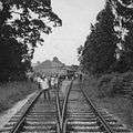 The train at Bovey Tracey.
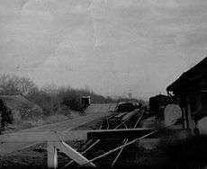 Teigngrace clay sidings.
Chronology
- 1862 Moretonhampstead and South Devon Railway authorised by Act of Parliament
- 1866 Railway opened
- 1872 Amalgamated with the South Devon Railway Company
- 1876 South Devon Railway amalgamated with the Great Western Railway
- 1882 Standard gauge Teign Valley Railway opened from Heathfield
- 1892 Broad gauge converted to standard gauge
- 1928 Brimley Halt opened
- 1948 Great Western Railway nationalised into British Railways
- 1955 Hawkmoor Halt renamed to Pullabrook Halt
- 1959 Passenger trains withdrawn
- 1964 Goods trains withdrawn beyond Bovey
- 1970 Goods trains withdrawn beyond Heathfield
- 2011 Goods trains reinstated as far as Heathfield to serve a timber siding at Teigngrace.
- 2015 Goods services withdrawn with last goods train running on 2 April 2015. Timber loading moved to Riverside, Exeter.
Route
Moretonhampstead and South Devon Railway | |
|---|---|
Legend
|
The Down direction was from Newton Abbot to Moretonhampstead, broadly northwards.
The route rises gradually from Newton Abbot as far as Heathfield, and the gradient then steepens, climbing continuously from Bovey with a long length at 1 in 49 from Lustleigh.
- Newton Abbot goods yard was positioned alongside the branch from June 1911, having been relocated to make space for the passenger station enlargement. It was on the Down (west) side of the line and had twelve roads. Newton Abbot Goods signal box was provided at the north end, until 1926 when it was replaced by a ground frame. Goods traffic ceased in 1970.[10]
The Stover Canal ran alongside the line on the Up side from near Kingsteignton bridge to Ventiford Bridge, a little north of Teigngrace.
- Nearly a mile further were Teignbridge sidings, laid in 1890.
- Teigngrace station was provided at the insistence of the Lord of the Manor of Stover. It was closed from 1 January 1917 to 1 May 1919 as a war economy measure.
- Heathfield station. This was originally named Chudleigh Road, and was renamed from 2 October 1882. The line from Exeter via Chudleigh terminated here in a north-east facing bay platform; it was only connected for shunting movements until 2 October 1916, when a running connection was provided; it was made a full double junction from May 1943. The intention was to make the Chudleigh route a diversionary route if the Dawlish route should become blocked by enemy action.[10]
- Brimley Halt. Opened 21 May 1928.
- Bovey. Served the community of Bovey Tracey.
- Pullabrook Halt. Opened as Hawkmoor until 13 June 1955. It served Hawkmoor County Sanatorium.
- Lustleigh.
- Moretonhampstead. The terminus had an all-over roof covering the platform and the run-round loop.[10]
References
- ↑ Beck, Keith; Copsey, John (1990). The Great Western in South Devon. Didcot: Wild Swan Publications. ISBN 0-906867-90-8.
- ↑ Rowe J. Book of Lustleigh. 2001.
- ↑ Kingdom, Anthony. R.; Lang, Mike (2004). The Newton Abbot to Moretonhampstead Railway. Liverton, Newton Abbot: Forest Publishing. p. 318. ISBN 1-873029-09-8.
- ↑ Hawkins, Michael (1988). Devon Roads – an illustrated survey of the development and management of Devon's highway network. Exeter: Devon Books. pp. 63, 233. ISBN 0-86114-817-7.
- ↑ Jenkins, S C; Pomroy, L J (1989). The Moretonhampstead and South Devon Railway. Oxford: Oakwood Press. ISBN 0-85361-389-3.
- ↑ Jacobs, G.A. (2009). "Trackwatch". Modern Railways. Ian Allan. 66 (731): 17. ISSN 0026-8356.
- ↑ "Disused Devon freight line to transport timber to Wales". BBC News – Devon. 7 December 2011. Retrieved 2011-12-07.
- ↑ "Heathfield Branch Developments". RM Web. 6 December 2011. Retrieved 2011-12-07.
- ↑ "Road to shut as bridge installed". Local World. 22 March 2011. Retrieved 6 December 2014.
- 1 2 3 Vic Mitchell and Keith Smith, Branch Line to Moretonhampstead, including Heathfield to Exeter, Middleton Press, Midhurst, 1998, ISBN 1 901706 27 3
See also
- Haytor Granite Tramway granite siding near Bovey
| Wikimedia Commons has media related to Moretonhampstead Branch Line. |