Moreland Township, Lycoming County, Pennsylvania
| Moreland Township, Pennsylvania | |
|---|---|
| Township | |
|
Tower for drilling horizontally into the Marcellus Shale Formation for natural gas, from Pennsylvania Route 118 in eastern Moreland Township | |
 Map of Lycoming County, Pennsylvania highlighting Moreland Township | |
 Map of Lycoming County, Pennsylvania | |
| Coordinates: 41°11′47″N 76°39′28″W / 41.19639°N 76.65778°WCoordinates: 41°11′47″N 76°39′28″W / 41.19639°N 76.65778°W | |
| Country | United States |
| State | Pennsylvania |
| County | Lycoming |
| Settled | 1790 |
| Formed | 1813 |
| Area | |
| • Total | 23.9 sq mi (62.0 km2) |
| • Land | 23.9 sq mi (62.0 km2) |
| • Water | 0.0 sq mi (0.0 km2) |
| Elevation | 1,198 ft (365 m) |
| Population (2000) | |
| • Total | 1,036 |
| • Density | 43.3/sq mi (16.7/km2) |
| Time zone | Eastern Time Zone (North America) (UTC-5) |
| • Summer (DST) | EDT (UTC-4) |
| ZIP code | 17756 |
| Area code(s) | 570 |
| FIPS code | 42-50936[1] |
| GNIS feature ID | 1216762[2] |

Moreland Township is a township in Lycoming County, Pennsylvania, United States. The population was 1,036 at the 2000 census. It is part of the Williamsport, Pennsylvania, Metropolitan Statistical Area.
History
It was divided into three townships in 1822. One part kept the name Moreland and the other two parts were called Penn and Franklin Townships.[3]
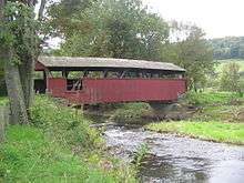
The Lairdsville Covered Bridge was added to the National Register of Historic Places in 1980. The Houseknecht Farm was added in 2007.[4]
The name
There are several stories about how Moreland Township was named. One story states that an early pioneer to the West Branch Susquehanna River Valley was climbing up and down the hills and upon reaching the top of a hill exclaimed, "more land!". Another story relates to the "sloppiness" of the earliest land surveys. An acre was not necessarily measured accurately. These particular acres were larger than they were supposed to be. The early settlers liked to say that they got "more land" to the acre here than they could have elsewhere. The most likely reason relates to an arcane definition of moreland, meaning "a hilly country".[5]
Early settlers
A veteran of the American Revolutionary War was the first settler in Moreland Township. Colonel George Smith migrated to Moreland Township from Montgomery County in 1790. He built a gristmill there in 1796. Smith and his wife were the parents of 6 children, 3 boys and 3 girls. The marriage of his daughter, Annie to a Quaker named William Farr causes some controversy in the early history of Moreland Township. William Farr came from a strict Quaker family and they did not look kindly upon his choice of bride. The local Quaker congregation insisted that Farr confess that he had done wrong in marrying outside his faith. Farr refused to do so and insisted that his Baptist wife, Annie, was a good Christian woman. Farr was forced to choose between his Quaker faith and his Baptist wife. He chose his wife and converted to the Baptist faith. Colonel Smith's son, Jonathan, also had a marriage that proved to be interesting. He married Annie Simpson, the sister of John Simpson of Ohio. John Simpson was the grandfather of Ulysses S. Grant who became President of the United States. This family bond meant that many of the residents of Moreland Township in the mid-19th century were second cousins to the man who served as their President.[5]
Geography
Moreland Township is bordered by Columbia and Montour Counties to the south, Muncy Creek and Wolf Townships to the west, Penn Township to the north, and Franklin Township to the east.[6] As the crow flies, Lycoming County is about 130 miles (209 km) northwest of Philadelphia and 165 miles (266 km) east-northeast of Pittsburgh.
According to the United States Census Bureau, the township has a total area of 23.9 square miles (62.0 km2), all of it land.
Demographics
As of the census[1] of 2000, there were 1,036 people, 367 households and 311 families residing in the township. The population density was 43.3 per square mile (16.7/km2). There were 391 housing units at an average density of 16.3/sq mi (6.3/km2). The racial makeup of the township was 99.52% White, 0.19% African American, 0.10% Native American, and 0.19% from two or more races.
There were 367 households, of which 37.3% had children under the age of 18 living with them, 75.7% were married couples living together, 4.4% had a female householder with no husband present, and 15.0% were non-families. 12.3% of all households were made up of individuals, and 6.5% had someone living alone who was 65 years of age or older. The average household size was 2.82 and the average family size was 3.08.
In the township the population was spread out, with 26.9% under the age of 18, 6.1% from 18 to 24, 29.2% from 25 to 44, 25.0% from 45 to 64, and 12.8% who were 65 years of age or older. The median age was 40 years. For every 100 females there were 104.3 males. For every 100 females age 18 and over, there were 100.8 males.
The median income for a household in the township was $41,528, and the median income for a family was $46,000. Males had a median income of $32,273 versus $24,464 for females. The per capita income for the township was $17,680. About 5.8% of families and 6.6% of the population were below the poverty line, including 8.1% of those under age 18 and 9.2% of those age 65 or over.
References
- 1 2 "American FactFinder". United States Census Bureau. Retrieved 2008-01-31.
- ↑ "US Board on Geographic Names". United States Geological Survey. 2007-10-25. Retrieved 2008-01-31.
- ↑ A Picture of Lycoming County (PDF). The Lycoming County Unit of the Pennsylvania Writers Project of the Work Projects Administration (First ed.). The Commissioners of Lycoming County Pennsylvania. 1939. Retrieved 2007-03-26.
- ↑ National Park Service (2010-07-09). "National Register Information System". National Register of Historic Places. National Park Service.
- 1 2 Meginness, John Franklin (1892). "Muncy Creek, Moreland, Franklin, and Jordan". History of Lycoming County, Pennsylvania: including its aboriginal history; the colonial and revolutionary periods; early settlement and subsequent growth; organization and civil administration; the legal and medical professions; internal improvement; past and present history of Williamsport; manufacturing and lumber interests; religious, educational, and social development; geology and agriculture; military record; sketches of boroughs, townships, and villages; portraits and biographies of pioneers and representative citizens, etc. etc. (1st ed.). Chicago: Brown, Runk & Co. ISBN 0-7884-0428-8. Retrieved 2007-03-26.
(Note: ISBN refers to Heritage Books July 1996 reprint. URL is to a scan of the 1892 version with some OCR typos).
- ↑ "2007 General Highway Map Lycoming County Pennsylvania" (PDF) (Map). 1:65,000. Pennsylvania Department of Transportation, Bureau of Planning and Research, Geographic Information Division. Retrieved 2009-12-26.
Municipalities and communities of Lycoming County, Pennsylvania, United States | ||
|---|---|---|
| City | | |
| Boroughs | ||
| Townships |
| |
| CDPs | ||
| Unincorporated communities | ||
| Ghost town | ||
| Footnotes | ‡This populated place also has portions in an adjacent county | |