Mooreville, Mississippi
| Mooreville, Mississippi | |
|---|---|
| Census-designated place (CDP) | |
 Mooreville, Mississippi  Mooreville, Mississippi | |
| Coordinates: 34°15′54″N 88°34′37″W / 34.26500°N 88.57694°WCoordinates: 34°15′54″N 88°34′37″W / 34.26500°N 88.57694°W | |
| Country | United States |
| State | Mississippi |
| County | Lee |
| Area[1] | |
| • Total | 2.794 sq mi (7.24 km2) |
| • Land | 0 sq mi (0 km2) |
| • Water | 0 sq mi (0 km2) |
| Elevation | 394 ft (120 m) |
| Population (2010) | |
| • Total | 94 |
| Time zone | Central (CST) (UTC-6) |
| • Summer (DST) | CDT (UTC-5) |
| ZIP code | 38857 |
| Area code(s) | 662 |
| GNIS feature ID | 2586604[2] |
Mooreville is a census-designated place located in Lee County, Mississippi. It is part of the Tupelo Micropolitan Statistical Area. Mooreville is approximately 4 miles (6.4 km) west of Dorsey and approximately 4 miles (6.4 km) east of Tupelo on Mississippi Highway 178 near Interstate 22. It was named for the Moore family, its first settlers.[3]
Although an unincorporated community, Mooreville has a post office and a zip code (38857).[4]
References
- ↑ http://www.census.gov/geo/maps-data/data/docs/gazetteer/2010_place_list_28.txt
- ↑ U.S. Geological Survey Geographic Names Information System: Mooreville, Mississippi
- ↑ McElvaine, Robert S. (2013). Mississippi: The WPA Guide to the Magnolia State. University Press of Mississippi. ISBN 9781604732924.
- ↑ United States Postal Service (2012). "USPS - Postmaster Finder". Retrieved 2014-08-19.
Municipalities and communities of Lee County, Mississippi, United States | ||
|---|---|---|
| Cities | 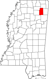 | |
| Towns | ||
| CDP | ||
Unincorporated communities | ||
| Footnotes | ‡This populated place also has portions in an adjacent county or counties | |
This article is issued from Wikipedia - version of the 7/30/2016. The text is available under the Creative Commons Attribution/Share Alike but additional terms may apply for the media files.