Pembridge
| Pembridge | |
 Market Place, with the open-sided Market Hall in the foreground and the New Inn beyond |
|
 Pembridge |
|
| Population | 1,056 (2011 Census) |
|---|---|
| OS grid reference | SO39581 |
| Civil parish | Pembridge |
| Unitary authority | Herefordshire |
| Ceremonial county | Herefordshire |
| Region | West Midlands |
| Country | England |
| Sovereign state | United Kingdom |
| Post town | Hereford |
| Postcode district | HR6 |
| Dialling code | 01544 |
| Police | West Mercia |
| Fire | Hereford and Worcester |
| Ambulance | West Midlands |
| EU Parliament | West Midlands |
| UK Parliament | North Herefordshire |
| Website | Pembridge Parish Council |
|
|
Coordinates: 52°13′05″N 2°53′35″W / 52.218°N 2.893°W
Pembridge is a village and civil parish in Arrow valley in Herefordshire, England. The village is on the A44 road about 6 miles (10 km) east of Kington and 6 1⁄2 miles (10.5 km) west of Leominster. The civil parish includes the hamlets of Bearwood, Lower Bearwood, Lower Broxwood, Marston, Moorcot and Weston. The 2011 Census recorded the parish population as 1,056.[1]
Pembridge is the major part of the electoral ward of Pembridge and Lyonshall with Titley. The 2011 Census recorded the ward's population as 3,124.[2]
Toponym
The toponym "Pembridge" may be derived from the Welsh Pen-y-Bont, anglicised to its current spelling.[3]
Bridge
The sandstone bridge over the river Arrow was granted Grade II listed status in June 1987, giving it protection from unauthorised alteration or demolition.[4]
Parish church
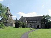
The oldest parts of St Mary's Church of England parish church are 12th-century, and the font and parts of the chancel are 13th-century. Most of the church has been dated c1320-60. Most spectacular are the arcades with circular cinquefoiled clerestory window. It is a cruciform church with 14th-century transepts and a vaulted north porch. There was a rood stair turret in the chancel with a pinnacle cover.
The pulpit preacher's desk, lectern and communion rail are Jacobean. A north vestry was added in the 19th century, and the building was restored in 1871 and 1903–09. The church is a Grade I listed building.[5] A knight and a lady were depicted tomb and effigy and a civilian and wife with a theirs were present from 14th century. There were memorial tablets to 17th c Sherborne family, and one to Thomas Trafford (d.1685).
Pembridge is one of several Herefordshire parishes whose belltower stands separate from the church. All but the base of the tower is timber-framed: one of a number of partly or largely timber-framed belltowers in Herefordshire. The tower was built early in the 13th century, rebuilt with the addition of an ambulatory in the 15th or 16th century, and further remodelled in the 17th-century when its spire was added. It is a Grade I listed building.[6]
The tower has a ring of five bells. John I Martin of Worcester cast the fourth bell in 1658. Abraham II Rudhall of Gloucester cast the treble bell in 1735. James Barwell of Birmingham cast or recast the first, second and tenor bells in 1898. St Mary's has also a Sanctus bell, which was cast about 1800.[7]
The churchyard contains seven Commonwealth war graves of service personnel, two from World War I and five from World War II.[8]
Economic and social history

In 1239 Pembridge was granted a royal charter to hold a market and two fairs: the Cowslip Fair held each May and the Woodcock Fair held each November. In the Middle Ages they were important events for agricultural labourers across the county to seek work from landowners.
The village is noted for its historic timber-framed buildings. It is promoted to visitors as "the heart of the Black and White Village Trail".[9]
In West Street, Swan House and School View are two parts of a single building. It was built in the 14th century a hall house, but had an intermediate floor inserted late in the 16th or early in the 17th century. It was further altered in the 19th and 20th centuries. It is a Grade II* listed building.[10] Also in West Street, Forsythia and West Leigh are two parts of another former hall house. It was built in the 14th or 15th century, and altered in the 17th and 19th centuries. It is a Grade II* listed building.[11]
In the Market Place, the core of the Post Office and Stores is another 14th-century house. It was remodelled in the 17th and late 19th centuries and is a Grade II* listed building.[12] Also in Market Place, the Market Hall is early 16th-century. It is an open-sided building that had an upper storey, but this was removed at an unknown date. It is a Grade II* listed building.[13]
In East Street is the former post office. It is a 15th-century house altered in the 17th and 19th centuries.[14]
%2C_Pembridge_-_geograph.org.uk_-_1105397.jpg)
Pembridge had two sets of almshouses, each divided into siex tenements. Duppa's Almshouses in Bridge Street were endowed by Jeffrey Duppa and founded in 1661. They were augmented by his son Brian Duppa,[15] a Royalist who was Bishop of Winchester from 1660 until his death in 1662. Trafford's Almshouses in East Street were endowed by the Rev Dr Thomas Trafford, DD, and built in 1686.[16]
Elsewhere in the parish, Clear Brook is a mainly 17th-century house with a 16th-century rear wing.[17] The Court of Noke is an 18th-century country house, and the most notable brick-built house in the parish.[18]
Former railway
Building of the Leominster and Kington Railway linking Leominster and Kington was started in 1855 and completed in 1857. It passed through Pembridge parish, where Pembridge railway station served the village. The Great Western Railway leased the line from the 1860s and absorbed it in 1898. British Railways closed the line to passenger traffic in 1955 and freight in 1961.
Amenities

Ye Olde Steppes in East Street is both the village shop and a café and tea room.[19] It is in a 16th-century building that was enlarged in the 17th-century and altered in the 19th-century.[20]
There is a 17th-century pub, the New Inn, in Market Place.[21] Pembridge had a 16th-century pub, the Greyhound Inn in East Street,[22] but this is now the King's House restaurant.[23] Also in the parish is the Cider Barn bar and restaurant at Hays Head, which opens seasonally.[24]
References
- ↑ "Area: Pembridge (Parish): Key Figures for 2011 Census: Key Statistics". Neighbourhood Statistics. Office for National Statistics. Retrieved 29 December 2015.
- ↑ "Area: Pembridge and Lyonshall with Titley (Ward): Key Figures for 2011 Census: Key Statistics". Neighbourhood Statistics. Office for National Statistics. Retrieved 29 December 2015.
- ↑ "Offa's Dyke". The Gentleman's Magazine. 103 (1): 504. June 1833.
- ↑ "Bridge over River Arrow - Pembridge - Herefordshire - England". British Listed Buildings. Retrieved 25 November 2016.
- ↑ Historic England. "Church of St Mary (Grade I) (1081754)". National Heritage List for England. Retrieved 29 December 2015.
- ↑ Historic England. "Belfry approximately 5 metres north-east of the Church of St Mary (Grade I) (1301249)". National Heritage List for England. Retrieved 29 December 2015.
- ↑ Dawson, George (31 August 2011). "Pembridge S Mary V". Dove's Guide for Church Bell Ringers. Central Council for Church Bell Ringers. Retrieved 29 December 2015.
- ↑ CWGC cemetery report, details from casualty record.
- ↑ "Home". Mediaeval Pembridge. Retrieved 29 December 2015.
- ↑ Historic England. "Swan House and School View (Grade II*) (1301065)". National Heritage List for England. Retrieved 29 December 2015.
- ↑ Historic England. "Forsythia and West Leigh (Grade II*) (1349914)". National Heritage List for England. Retrieved 29 December 2015.
- ↑ Historic England. "Pembridge Post Office and Stores (Grade II*) (1081730)". National Heritage List for England. Retrieved 29 December 2015.
- ↑ Historic England. "The Market Hall (Grade II*) (1081729)". National Heritage List for England. Retrieved 29 December 2015.
- ↑ Historic England. "Old Post Office and Old Post Office Cottage (Grade II) (1301160)". National Heritage List for England. Retrieved 29 December 2015.
- ↑ Historic England. "Duppa's Almshouses (Grade II) (1081719)". National Heritage List for England. Retrieved 29 December 2015.
- ↑ Historic England. "Trafford's Almshouses (Grade II) (1081726)". National Heritage List for England. Retrieved 29 December 2015.
- ↑ Historic England. "Clear Brook (Grade II*) (1081755)". National Heritage List for England. Retrieved 29 December 2015.
- ↑ Historic England. "Court of Noke (Grade II*) (1349923)". National Heritage List for England. Retrieved 29 December 2015.
- ↑ Ye Olde Steppes
- ↑ Historic England. "Ye Old Steppes (Grade II) (1166929)". National Heritage List for England. Retrieved 29 December 2015.
- ↑ Historic England. "The New Inn (Grade II) (1166993)". National Heritage List for England. Retrieved 29 December 2015.
- ↑ Historic England. "The Greyhound Inn (Grade II) (1081724)". National Heritage List for England. Retrieved 29 December 2015.
- ↑ The Kings House Restaurant
- ↑ The Cider Barn
Further reading
- Pevsner, Nikolaus (1963). Herefordshire. The Buildings of England. Harmondsworth: Penguin Books. pp. 266–269.
- RCHME, ed. (1934). "Pembridge". An Inventory of the Historical Monuments in the County of Herefordshire. 3, North West. London: Royal Commission on the Historical Monuments of England. pp. 159–169.
External links
| Wikimedia Commons has media related to Pembridge. |
- Pembridge Parish Council
- The Pembridge Amenity Trust
- The Arrowvale Group of Parishes
- Mediaeval Pembridge
- Ye Olde Steppes