Moor Crichel
| Moor Crichel | |
 Parish church of St Mary |
|
 Moor Crichel |
|
| Population | 140 (2013 estimate) |
|---|---|
| OS grid reference | ST993086 |
| Civil parish | Moor Crichel |
| District | East Dorset |
| Shire county | Dorset |
| Region | South West |
| Country | England |
| Sovereign state | United Kingdom |
| Post town | WIMBORNE |
| Postcode district | BH21 |
| Dialling code | 01258 |
| Police | Dorset |
| Fire | Dorset and Wiltshire |
| Ambulance | South Western |
| EU Parliament | South West England |
| UK Parliament | North Dorset |
Coordinates: 50°52′37″N 2°00′40″W / 50.877°N 2.011°W
Moor Crichel is a village and civil parish in East Dorset, England situated on Cranborne Chase five miles east of Blandford Forum. The civil parish includes the hamlet of Manswood notable for a terrace of twelve thatched cottages. Dorset County Council's 2013 estimate of the parish population is 140.[1] In the 2001 census the parish had a population of 180.[2] In the 2011 census the population of Moor Crichel parish combined with the neighbouring parish of Long Crichel was 246 (figures have not been released for Moor Crichel separately).[3]
History

At first, Moor Crichel was made up of two original settlements with different pieces of land attached to them. These two settlements were Little Crichel towards the north west of the parish where the village was close to Norwood Park; and Moor Crichel (More Crichel) in the south east of the parish which was close to the church of St. Mary until the latter part of the 18th Century. After this time, to make way for the extension of the park of Crichel House, the settlements were cleared and many of the inhabitants moved on to nearby Witchampton. Manswood to the west of the parish may be connected to the medieval settlement Chetterwood from 1215, although the earliest building there now is a farmhouse dated 1725.[4]
Moor Crichel is mentioned in the Domesday Book and is said to have had 38.3 households. The Lord in 1066 was King Edward but this changed in 1086 to King William who was also the tenant-in-chief for 1086.[5]
Notable buildings
Eleven structures within Moor Crichel parish have been listed by Historic England for their historical or architectural interest. Crichel House is listed as Grade I, the designation of highest significance, and the other ten are Grade II.[6]
Crichel House
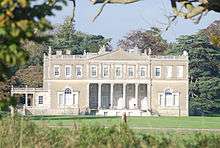
In the 16th Century, Crichel House was owned by the Uvedales and then ownership changed to the Sturts. In a fire in 1742, the house was ruined and was rebuilt for Sir William Napier. When the estate was passed on in 1765 to Humphrey Sturt, the house was modified massively. To make way for new parkland, the village was moved south; due to this the original site of Moor Crichel is now beneath the lake.[7]
In 1870–72 John Marius Wilson described Crichel House as "Critchell-Moore House is the seat of H.Sturt, Esq. The living is a rectory, united with the rectory of Long Critchell, in the diocese of Salisbury".[8]
Church of St. Mary
The Church of St. Mary can be found in the grounds of Crichel House. In 1850, Henry Charles Sturt paid to build the Church of St Mary to replace the building which preceded it. After 1973, the church was no longer used however it remains to be an important part of the Crichel Estate.[9] The parish church of St. Mary is in the grounds of Crichel House and not accessible to the public.
Demography
The data used to make the below observations of Moor Crichel's demography in recent years comes from the 2011 Census for Moor Crichel parish which also includes Long Crichel.[10]
Population

The population of Moor Crichel started out in 1801 at 268 and then decreased slightly to 267 by 1821. After this brief period of decreasing population, the area experienced a fairly rapid increase to 374 in 1851. At this point, the population fell slightly again to 367 in 1881 only to once again experience a rapid increase to 407 in 1891 which remains to be the highest population that Moor Crichel has had to date. After this, Moor Crichel's population began to fall again until 1921 when it became fairly constant at around 255 until 1961.[11] In more recent years, the population of Moor Crichel experienced a small rise in 2001 to 262.[12] However, in 2011 the population fell again to around 246.[13]
Occupation


The occupations of people in Moor Crichel have changed dramatically between 1881 and 2011. In 1881 there were many more men working than there were women, with 16 women working in no specified profession and only 2 men. Most people worked in agriculture, with 50 men and 1 woman working in that industry; and the most prevalent profession for women was domestic services, with 31 women and 14 men working in that area. There were only 4 professional workers, 3 of whom were women.[14]
By comparison in 2011 the amount of people working in professional occupations has increased. There were 18 managers, directors or senior officials; 17 people in professional occupations; and 12 associate or technical professionals. In contrast, the number of people working in more agricultural-based professions decreased. Only 9 people worked in process, plant and machine operation. Skilled trades were the most prevalent occupations in 2011, employing 36 people.[15] Of the 137 employed people living in Moor Crichel, 75 were men. The skilled trades were the most prevalent occupations with 29 men working in these professions.[16] Out of these 137 working people, 62 of them were women. The caring, leisure or service occupations being the most prevalent among them with 16 women working in this area.[17]
Age Structure
The largest age group in Moor Crichel according to the 2011 Census was 45–59 which accounted for 29.3% of the area's population, with the 30–44 age group being the second largest at 17.9% of the population. The largest age group in the 0–18 category is the 10–14 age group who make up a fairly large 6.9% of the population.[18]
Ethnicity
The largest ethnic group in Moor Crichel with 96.7% of the population is White British as reported by the 2011 Census. The remaining is made up of 2.9% Irish White or Other White ethnicities and 0.4% Other Asian/Asian British.[19]
References
- ↑ "Parish Population Data". dorsetforyou.com. Dorset County Council. 20 January 2015. Retrieved 28 January 2016.
- ↑ Parish & Ward Population Estimates for Dorset 1992–2004
- ↑ "Key Figures for 2011 Census: Key Statistics for Moor Crichel". Neighbourhood Statistics. Office for National Statistics. Retrieved 23 April 2016.
- ↑ "Moor Crichel | British History Online". www.british-history.ac.uk. Retrieved 2016-03-20.
- ↑ "Open Domesday (Moor Crichel)". Open Domesday. University of Hull. Retrieved 24 April 2016.
- ↑ "Listed Buildings in Moor Crichel, Dorset, England". britishlistedbuildings.co.uk. Retrieved 25 April 2016.
- ↑ "The Parish of Moor Crichel". www.opcdorset.org. Retrieved 2016-03-23.
- ↑ Wilson, John Marius (1870–72). Imperial Gazetteer of England and Wales. Edinburgh: A. Fullerton & Co.
- ↑ Day, Michael (27 January 2015). "Moor Crichel (Former Church of St. Mary)". www.dorset-churches.org.uk. Retrieved 2016-03-20.
- ↑ "Moor Crichel Area Map". Neighbourhood Statistics. Office for National Statistics. Retrieved 24 April 2016.
- ↑ "Moor Crichel Population Table from 1801 to 1961". A Vision of Britain through Time. University of Portsmouth. Retrieved 23 April 2016.
- ↑ "Key Figures for 2001 Census: Key Statistics for Moor Crichel". Neighbourhood Statistics. Office for National Statistics. Retrieved 23 April 2016.
- ↑ "Key Figures for 2011 Census: Key Statistics for Moor Crichel". Neighbourhood Statistics. Office for National Statistics. Retrieved 23 April 2016.
- ↑ "1881 Occupational Orders for men and women in Moor Crichel". A Vision of Britain through Time. University of Portsmouth. Retrieved 24 April 2016.
- ↑ "Occupation, 2011 Census for Moor Crichel". Neighbourhood Statistics. Office for National Statistics. Retrieved 24 April 2016.
- ↑ "Occupation of males, 2011 Census for Moor Crichel". Neighbourhood Statistics. Office for National Statistics. Retrieved 24 April 2016.
- ↑ "Occupations of females, 2011 Census for Moor Crichel". Neighbourhood Statistics. Office for National Statistics. Retrieved 24 April 2016.
- ↑ "Age Structure, 2011 Census for Moor Crichel". Neighbourhood Statistics. Office for National Statistics. Retrieved 24 April 2016.
- ↑ "Ethnic Group, 2011 Census for Moor Crichel". Neighbourhood Statistics. Office for National Statistics. Retrieved 24 April 2016.
| Wikimedia Commons has media related to Moor Crichel. |