Montrose, Houston

Montrose is a primarily residential neighborhood located in Houston, Texas, United States.[1][2] Established in 1911, the neighborhood is a demographically diverse area with renovated mansions, bungalows with wide porches, and cottages located along tree-lined boulevards. Montrose is a major cultural hub.
Montrose has been called the "Heart of Houston,"[3] the "strangest neighborhood east of the Pecos,"[4] and was named one of the "ten great neighborhoods in America" in 2009.[5]
History
Montrose was originally envisioned as a planned community and streetcar suburb dating back to the early 20th century before the development of River Oaks. Developer J. W. Link and his Houston Land Corporation envisioned a "great residential addition" according to the neighborhood's original sales brochure. Link's planning details for the area included four wide boulevards with the best curbing and extensive landscaping. Link built his own home in Montrose, known as the Link-Lee Mansion, which is now part of the University of St. Thomas campus.[6] A streetcar, the Montrose Line, ran through the neighborhood. Link wrote: "Houston has to grow. Montrose is going to lead the procession." It did, and the procession eventually continued far beyond the neighborhood.[6] Montrose was first platted in 1911.[7]
In 1926, the Plaza Apartment Hotel, Houston’s first apartment hotel, opened on Montrose Boulevard. The hotel was home to many of Houston’s leaders, including Dr. Edgar Odell Lovett, the first president of Rice University. Modeled after the Ritz-Carlton in New York, the hotel cost over one million dollars to construct.[8]
During the 1960s and 1970s, Montrose became a center for the burgeoning counterculture movement, with street musicians, alternative community centers and hippie communes, head shops and artisans’ studios proliferating. The corner of Montrose and Westheimer was the site of regular demonstrations against the Vietnam War. Street vendors sold Space City! and other underground newspapers throughout the area.[9]
KPFT – the fourth station in the progressive Pacifica Radio network of listener-sponsored stations – began broadcasting in 1970, and was joined on Lovett Blvd. by KLOL and KILT (Radio Montrose), pioneers in the underground FM format, creating a Montrose countercultural “radio row.” KPFT’s transmitter was twice bombed by a local Ku Klux Klan group, making it the only radio station in the history of the United States to be blown off the air.[10]
The Bohemian flavor of the Montrose would spawn both the Westheimer Colony Art Festival in 1971 and the subsequent street fair in 1973, which would become known as the Westheimer Street Festival. Also starting around the 1970s the area became known as the center for the gay and lesbian community of Houston. The area sported an estimated 30-40 gay bars at the time, including the Bayou Landing, thought to be the largest gay dance hall between the coasts, and several gay activist groups, including the Gay Liberation Front.[4]
Folk music clubs like Anderson Fair and Sand Mountain catered to the folk scene in the neighborhood and other venues featured psychedelic rock and blues. Later, punk and new wave clubs like The Paradise Rock Island, the Omni, and Numbers opened in the late 1970s and early 1980s. Montrose has been "a haven for Prohibition honkey-tonks, antique stores, wealthy socialites, motorcycle gangs, gays, harmless eccentrics and a broad array of exiles, writers, artists and musicians."[11] It has been called "a uniquely Houston kind of Bohemia, a mad mix made possible by the city's no-holds-barred, laissez faire form of growth." [3]
In 1991 Paul Broussard was murdered in the Montrose nightclub area. University of Houston professor Maria Gonzalez stated that "With this murder[...]people said, 'Enough is enough.'[...]A whole new relationship developed between the gay community and the police department."[12]
Since the 1990s, Montrose has become increasingly gentrified with a trend towards remodeled and new homes, higher rents, upmarket boutiques and restaurants.
On June 6, 2006,[13] a teenage MS-13 gang member named Gabriel Granillo was stabbed to death at Ervan Chew Park in the Montrose area. The 2011 novel The Knife and the Butterfly is based on this stabbing.[14]
Culture
Montrose hosts a number of communities including artists, musicians, and LGBTs, and has thrift, vintage, and second-hand shopping stores, gay bars, and restaurants. On Montrose Boulevard and Westheimer Road, there are few original homes remaining—a majority have been converted to businesses and/or restaurants since 1936. Examples of Houston's historic residential architecture including century-old bungalows and mansions can be found in Montrose.
LGBT culture
Before the 1970s, the city's gay bars were spread around Downtown Houston and what is now Midtown Houston. Gays and lesbians needed to have a place to socialize after the closing of the gay bars. They began going to Art Wren, a 24-hour restaurant in Montrose. Around the time Montrose mainly included empty nesters and widows. Gay men became attracted to Montrose as a neighborhood after encountering it while patronizing Art Wren, and they began to gentrify the neighborhood and assist the widows with the maintenance of their houses. Within Montrose new gay bars began to appear.[15] By 1985, the flavor and politics of the neighborhood were heavily influenced by the LGBT community.[16] At the time at least 19% of the residents of Montrose were gay and lesbian. In the late 1980s, AIDS affected many Montrose residents. Some area residents stopped patronizing restaurants in Montrose, believing that they would acquire AIDS from gay waiters. Some area funeral homes did not want to accept the bodies of men who died from AIDS. AIDS tore through the neighborhood and the gay community flocked to the nightclubs for a reprieve from sickness and death."[16] The Murder of Paul Broussard occurred in Montrose in 1991.[16] By 2011 many LGBT people moved to the Houston Heights and to suburbs in Greater Houston. Decentralizing of Houston's gay population and the increasing acceptance of homosexuality in the city of Houston and in society in general caused business at gay bars in Montrose to decline.[17]
Museums
The Menil Collection, on Sul Ross Street between Alabama Street and Richmond Avenue, is a free museum founded by Houston philanthropists John and Dominique de Menil to house their art collection.[18] The Menil was designed by architect Renzo Piano.
The Museum of Fine Arts, Houston is located in the Houston Museum District,[19] in the surrounding area.[20]
Chapels
The Rothko Chapel, also created by John and Dominique de Menil, is a non-denominational chapel located one block from the Menil. Fourteen black and color-hued paintings by Mark Rothko are on the interior walls. The shape and design of the chapel were largely influenced by the artist. Barnett Newman's sculpture, Broken Obelisk, dedicated to the late Martin Luther King, Jr., stands in front of the chapel in a reflecting pool designed by famed architect Philip Johnson.
The Chapel of St. Basil, designed by Philip Johnson, is on the campus of nearby University of St. Thomas (Texas). It is faced with white stucco and black granite, and is operated by the Congregation of St. Basil.
Infrastructure and government
Local government

The community is within the Houston Police Department's Central Patrol Division,[21] headquartered at 61 Riesner.[22] The Neartown Storefront Station is located at 802 Westheimer Road.[22] The City of Houston purchased the building used for the storefront with federal community development funds.
Houston Fire Department Fire Station 16 serves the area. The fire station is in Fire District 6.[23] The station opened at the intersection of Westheimer Road and Yupon in 1928. The station moved to the intersection of Richmond and Dunlavy in 1979.[24]
Montrose is within Houston City Council District C. Because of the inclusion of Montrose, the Houston Heights, and the Rice University area, District C is nicknamed "hipstrict" referring to its progressive and urban ethic.[25] Previously Montrose was wholly within City Council District D.[26] In the early 1990s, Montrose was moved from District C to district D to avoid putting too many minorities in a single city council district.[27] While Montrose was in District D, it was not able to have its own residents elected to city council. Instead the district was forced to try to influence electoral contests involving candidates from other neighborhoods.[28] As 2011 city council redistricting approached, some members of Houston's gay community and some Houston area bloggers proposed returning Montrose to District C.[27] Around 2011 an earlier plan would have combined the Heights and Montrose under a district called District J.[29]
It is also home to Mayor Annise Parker. Parker, a longtime resident of Montrose, started her political career by representing Montrose as an at-large city council member.[28] It is also home to At-Large Council Members Sue Lovell and Stephen Costello.
County, state, and federal representation
Harris County Precinct One, as of 2008 headed by El Franco Lee, serves Neartown. The county operates the Neartown Office at 1413 Westheimer Road.[30]
Montrose is located in Districts 134 and 147 of the Texas House of Representatives. Sarah Davis represents the portion of the neighborhood west of Montrose Boulevard,[31] and Garnet Coleman represents the portion of the neighborhood east of Montrose Boulevard.[32] Montrose is located in District 13 of the Texas Senate.[33] Rodney Ellis represents the district.
The community is within Texas's 7th congressional district.[34] As of 2008 the representative is John Culberson.
City of Houston Designated Historic Districts
As of June 2010, The Montrose was home to six of the nineteen designated Historic Districts in the city of Houston.[35] These are Audubon Place,[36] Avondale East,[36] Avondale West,[37] Courtland Place,[38] Westmoreland,[39] and First Montrose Commons.[40]
Past elections
Montrose held the core of Mayor of Houston Kathy Whitmire's political support in the late 1970s and early 1980s. Montrose was the only area where a plurality of residents (40%) voted for her in the 1991 Mayor of Houston election.[41] Montrose provided political support for former city councilperson and mayor Annise Parker.
Economy
Montrose is served by major regional and national supermarket chains including H-E-B, Whole Foods, Trader Joe's, Kroger and Randall's.[42] Several of the supermarkets introduced new features or underwent renovations to attract customers.[43]
Consulates
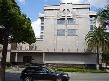
The Consulate-General of the People's Republic of China in Houston and Consulate-General of Norway are located in Montrose.[44] [45]
Parks and recreation
The Houston Greek Festival is held near the Annunciation Greek Orthodox Cathedral. The festival is usually in the first week of October and has been held for over four decades.[46]
The Montrose Crawl is a pub crawl that takes place along Westheimer Road in Montrose on the last Saturday in October. A portion of all beverage sales made during the crawl are donated to charity.[47]
The Montrose Remembrance Garden, a memorial to victims of violent crimes, was established in 2011 at the intersection of California and Grant streets.[48] Ervan Chew Park is a neighborhood park that allows dogs off-leash in a designated area.
Education
Colleges and universities

Montrose is home to the University of St. Thomas. It is also close to Rice University, The University of Texas Health Science Center at Houston, the University of Houston, Texas Southern University, Houston Community College Central, and University of Houston–Downtown.
Primary and secondary education
Public schools

Pupils in Montrose are zoned to Houston Independent School District schools.[2] Montrose is in Trustee District VIII, represented by Diana Dávila as of 2008.[49]
MacGregor Elementary School,[50] Poe Elementary School,[51] Wharton Elementary School,[52] and Wilson Elementary School serve separate sections of Montrose.[53]
Pupils in Montrose are divided between two separate middle school attendance boundaries. Lanier Middle School and Gregory-Lincoln Education Center serve separate sections of Neartown for middle school.[54][55] All Montrose pupils are zoned to Lamar High School.[56] High School for the Performing and Visual Arts, a magnet high school, is in Montrose.
Montrose Elementary School opened in 1906. It was later torn down and replaced in 1982 by the High School for the Performing and Visual Arts .[57] Southmore Elementary School opened in 1921, Wilson in 1925, Lanier in 1926, Poe in 1928, and Wharton in 1929. Southmore was renamed MacGregor Elementary School in 1930 and Lamar opened in 1937. Gregory-Lincoln opened in 1966, and Gregory-Lincoln's current facility opened in 2007.[58]
Private schools
The Annunciation Orthodox School and The Harris School are located in Montrose.[59][60] The Kinkaid School was located in the Neartown area until 1957 when the school moved to Piney Point Village.[61]
Public libraries
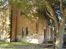
The Eleanor K. Freed-Montrose Neighborhood Library of Houston Public Library is at 4100 Montrose Boulevard.[62] The library is housed in a former church, the Central Church of Christ. The bell tower or campanile is located by the front door of the library although the bell is gone, and there is a small colonnade connecting the main church-library building to former church meeting rooms and offices. Facing Montrose Boulevard, the original stained glass window of the church can be seen featuring a dove with an olive branch in its beak. A modern office building complex in the surrounding area is known as The Campanile, named after the bell tower in the library.
Notable natives and residents


- Clark Gable studied acting in the neighborhood[4]
- Howard Hughes's former home on Yoakum Street is now part of the University of St. Thomas
- Lyndon Johnson lived on Hawthorne Street while teaching high school in the 1930s[63]
- Sue Lovell, a member of the Houston City Council[64]
- Annise Parker (Mayor of Houston, former at-large Houston City Council member)[28]
- Parker resides in East Montrose as of 2002; she had lived there since around 1991.[65]
- The mansion of Ross S. Sterling, originally located in Downtown Houston, was moved into the neighborhood. The Waldo Mansion is also in the neighborhood.
- William Sydney Porter (O. Henry) lived in the Montrose while a reporter for the Houston Post[4]
See also
References
- ↑ Map of Neartown. Neartown Association. Retrieved October 20, 2008.
- 1 2 Map of Montrose. Houston Chronicle. Retrieved October 20, 2008.
- 1 2 Dreyer, Thorne. "The Mad Mix: Montrose, The Heart of Houston," CITE: The Architecture and Design Magazine of Houston, Summer 2010.
- 1 2 3 4 Dreyer, Thorne and Al Reinert, "Montrose Lives!" (Archive), Texas Monthly, April 1973
- ↑ American Planning Association, "Great Places in America", 2009
- 1 2 "In Montrose, Houston First Went Boom, Kathryn Jones (March 24, 2002)". nytimes.com. March 24, 2002. Retrieved 2007-06-02.
- ↑ "About the Neartown Association." Neartown Association. September 29, 2007.
- ↑ "The Plaza Apartment Hotel". historichouston.org. Archived from the original on 2007-09-30. Retrieved 2007-06-02.
- ↑ Counterculture issue, Cite 82 Summer 2010.
- ↑ Shey, Brittany, "The Day the KKK Bombed Pacifica," Houston Press, May 12, 2010.
- ↑ Dreyer, Thorne and Al Reinert. "Montrose Lives!" Texas Monthly. April 1973. ISSN 0148-7736. Page 56. Retrieved from Google Books on April 2, 2010.
- ↑ Turner, Allan. "Documentary film reconsiders Montrose gay killing." Houston Chronicle. April 19, 2015. Retrieved on November 12, 2015.
- ↑ Rogers, Brian. "3 years after gang killing, teen wants to 'move on'" (Archive). Houston Chronicle. Thursday September 17, 2009.
- ↑ Pérez, Ashley Hope. The Knife and the Butterfly. Lerner Publishing Group, August 1, 2014. ISBN 1467716243, 9781467716246. p. 205.
- ↑ Oaklander, Mandy. "The Mayor of Montrose." Houston Press. Wednesday May 18, 2011. 1. Retrieved on May 18, 2011.
- 1 2 3 Oaklander, Mandy. "The Mayor of Montrose." Houston Press. Wednesday May 18, 2011. 2. Retrieved on May 18, 2011.
- ↑ Oaklander, Mandy. "The Mayor of Montrose." Houston Press. Wednesday May 18, 2011. 4. Retrieved on May 18, 2011. '"Gay bars used to be places where we had to go to get refuge because we were not welcome anywhere else," he says. "Well, guess what? There's nowhere we're not welcome anymore."'
- ↑ "MENIL COLLECTION, Handbook of Texas Online, Linda Peterson". tshaonline.org. Retrieved 2007-06-02.
- ↑ "Museum of Fine Arts Houston seeking donations." Houston Chronicle. December 13, 2013. Retrieved on November 1, 2014. "The Museum of Fine Arts Houston is in the heart of the city's Museum District."
- ↑ "MUSEUM OF FINE ARTS, HOUSTON, Handbook of Texas Online, Kendall Curlee". tshaonline.org. Retrieved 2007-06-02. "The Museum of Fine Arts, in the Montrose area of Houston, is the oldest art museum in Texas. "
- ↑ "Crime Statistics for Central Patrol Division." City of Houston. Retrieved May 23, 2008.
- 1 2 "Volunteer Initiatives Program, Citizens Offering Police Support." City of Houston. Retrieved May 23, 2008.
- ↑ "Fire Stations." City of Houston. Retrieved December 11, 2008.
- ↑ "Fire Station 16." City of Houston. Retrieved on April 3, 2010.
- ↑ Moran, Chris. "Only 2 city incumbents lack opponents." Houston Chronicle. Thursday September 8, 2011. Retrieved on November 5, 2011.
- ↑ "." District D Homepage
- 1 2 "Jigsaw puzzle: Creating two new Houston City Council seats poses demographic challenges." (editorial) Houston Chronicle. Wednesday January 26, 2011. Retrieved on November 5, 2011.
- 1 2 3 "Political challenge: Revised council redistricting plan offers Hispanics a third majority district." (editorial) Houston Chronicle. Wednesday May 18, 2011. Retrieved on November 5, 2011.
- ↑ Connelly, Richard. "City Council Redistricting Map: Montrose and the Heights, (Somewhat) Together." Houston Press. April 6, 2011. Retrieved on November 5, 2011.
- ↑ "Office Locations." Harris County Precinct One. Accessed October 13, 2008.
- ↑ "Map of Texas House District 134." Texas House of Representatives. Accessed June 9, 2010.
- ↑ "Map of Texas House District 147." Texas House of Representatives. Accessed June 9, 2010.
- ↑ "Senate District 13" Map. Senate of Texas. Accessed September 28, 2008.
- ↑ "Congressional District 7." National Atlas of the United States. Retrieved May 23, 2008.
- ↑
- 1 2
- ↑
- ↑
- ↑
- ↑
- ↑ Bernstein, Alan and Jim Simmon. "Black vote went solidly for Turner/Whitmire failed to produce split." Houston Chronicle. Thursday November 7, 1991. A21. "The only area where Whitmire ran first Tuesday was in Montrose, which provided the core of her political base in the late 1970s and early 1980s."
- ↑ Foster, Robin. "Influx of grocery stores means more choices, but concerns linger" (Archive). Houston Chronicle. Wednesday October 19, 2011. Retrieved on November 11, 2015.
- ↑ Kaplan, David. "H-E-B's Montrose Market will have many firsts" (Archive). Houston Chronicle. Wednesday November 9, 2011. Retrieved on November 11, 2015.
- ↑ Home. Consulate-General of the People's Republic of China in Houston. Retrieved on January 10, 2009.
- ↑ http://www.norway.org/Embassy/houston/About-Our-Consulate-General/
- ↑ "The Original Greek Festival, Houston, Texas". greekfestival.org. Retrieved 2007-06-02.
- ↑ "The Montrose Crawl". montrosecrawl.com. Retrieved 2008-11-26.
- ↑ Mathis, Lauren. "Montrose garden helps plant seeds of change against violence." Houston Chronicle. August 6, 2011. Retrieved on August 6, 2011.
- ↑ "Trustee Districts Map." Houston Independent School District. Retrieved on November 11, 2008.
- ↑ "MacGregor Elementary School Attendance Boundary," Houston Independent School District. Retrieved October 20, 2008.
- ↑ "Poe Elementary School Attendance Boundary," Houston Independent School District. Retrieved October 20, 2008.
- ↑ "Wharton Elementary School Attendance Boundary," Houston Independent School District. Retrieved October 20, 2008.
- ↑ "Wilson Elementary School Attendance Boundary," Houston Independent School District. Retrieved October 20, 2008.
- ↑ "Gregory-Lincoln Middle School Attendance Boundary," Houston Independent School District. Retrieved October 20, 2008.
- ↑ "Lanier Middle School Attendance Boundary," Houston Independent School District. Retrieved October 20, 2008.
- ↑ "Lamar High School Attendance Boundary," Houston Independent School District. Retrieved October 20, 2008.
- ↑ The National Elementary Principal, Volume 51. National Association of Elementary School Principals, 1945. Page 326. Digitized by Google Books on October 27, 2008. Retrieved on January 1, 2010. "Montrose Elementary School, 4011 Stanford, Houston."
- ↑ "School Histories: the Stories Behind the Names." Houston Independent School District. Accessed September 24, 2008.
- ↑ Radcliffe, Jennifer. "When all else fails, school offers troubled kids hope." Houston Chronicle. Friday January 1, 2010. Retrieved on February 12, 2012.
- ↑ "Home." The Harris School. Retrieved on February 12, 2012. "900 Lovett Blvd Houston, TX 77006"
- ↑ Kinkaid School from the Handbook of Texas Online
- ↑ "Freed-Montrose Neighborhood Library." Houston Public Library. Retrieved on December 11, 2008.
- ↑ "Houston: A city without zoning, Sherry Thomas (October 07, 2003)". usatoday.com. October 30, 2003. Retrieved 2007-06-02.
- ↑ Gustin, Marene. "Is Ervan Chew Park safe?" (Archive). River Oaks Examiner. Thursday June 15, 2006. Retrieved on November 11, 2015.
- ↑ Snyder, Mike. "East Montrose retains flavor after gentrification" (Archive). Houston Chronicle. Sunday May 12, 2002. Retrieved on November 12, 2015. "The design of many of the new townhomes discourages interaction with neighbors, said City Councilwoman Annise Parker, who has lived in East Montrose for more than 11 years."
Further reading
- Smith, William, Michael. "3400 Montrose: Piece of Houston History Going...Going....Gone." Houston Press. Thursday May 15, 2014.
External links
| Wikimedia Commons has media related to Montrose, Houston. |
See also
Coordinates: 29°44′24″N 95°23′28″W / 29.740°N 95.391°W