Montravers
| Montravers | |
|---|---|
|
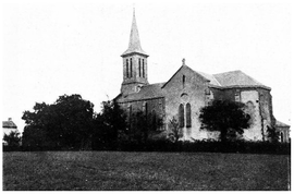
The church in Montravers | |
 Montravers | |
|
Location within Nouvelle-Aquitaine region  Montravers | |
| Coordinates: 46°49′46″N 0°43′01″W / 46.8294°N 0.7169°WCoordinates: 46°49′46″N 0°43′01″W / 46.8294°N 0.7169°W | |
| Country | France |
| Region | Nouvelle-Aquitaine |
| Department | Deux-Sèvres |
| Arrondissement | Bressuire |
| Canton | Cerizay |
| Intercommunality | Delta-Sèvre-Argent |
| Government | |
| • Mayor (2008–2014) | Jean-Claude Garnier |
| Area1 | 10.12 km2 (3.91 sq mi) |
| Population (2006)2 | 368 |
| • Density | 36/km2 (94/sq mi) |
| Time zone | CET (UTC+1) |
| • Summer (DST) | CEST (UTC+2) |
| INSEE/Postal code | 79183 / 79140 |
| Elevation |
141–198 m (463–650 ft) (avg. 186 m or 610 ft) |
|
1 French Land Register data, which excludes lakes, ponds, glaciers > 1 km² (0.386 sq mi or 247 acres) and river estuaries. 2 Population without double counting: residents of multiple communes (e.g., students and military personnel) only counted once. | |
Montravers is a commune in the Deux-Sèvres department in western France.
See also
References
| Wikimedia Commons has media related to Montravers. |
This article is issued from Wikipedia - version of the 3/7/2015. The text is available under the Creative Commons Attribution/Share Alike but additional terms may apply for the media files.