Monticello Dam
| Monticello Dam | |
|---|---|
 | |
| Location |
Vaca Mountains, Napa County, California. |
| Coordinates | 38°30′48″N 122°06′15″W / 38.5133°N 122.1042°WCoordinates: 38°30′48″N 122°06′15″W / 38.5133°N 122.1042°W |
| Construction began | 1953 |
| Opening date | 1957 |
| Operator(s) | Bureau of Reclamation |
| Dam and spillways | |
| Impounds | Putah Creek |
| Height | 304 ft (93 m) |
| Length | 1,023 ft (312 m) |
| Width (base) | 100 ft (30 m) |
| Reservoir | |
| Creates | Lake Berryessa |
| Total capacity | 1,602,000 acre·ft (1.976×10⁹ m3) |
| Catchment area | 566 sq mi (1,470 km2)[1] |
| Surface area | 20,700 acres (8,400 ha) |
| Power station | |
| Operator(s) | Solano Irrigation District |
| Commission date | 1983 |
| Turbines | 2 x 5 MW, 1 x 1.5 MW |
| Installed capacity | 11.5 MW |
| Annual generation | 56,806,000 KWh (2004)[2] |
| U.S. Geological Survey Geographic Names Information System: Monticello Dam | |
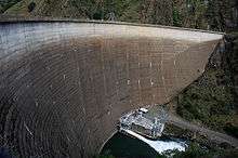
Monticello Dam is a 304-foot (93 m) high concrete arch dam in Napa County, California, United States constructed between 1953 and 1957. The dam impounded Putah Creek to create Lake Berryessa in the Vaca Mountains.
Lake Berryessa is currently the seventh largest man-made lake in California. Water from the reservoir primarily supplies agriculture in the Sacramento Valley downstream. The dam is noted for its classic, uncontrolled morning-glory type spillway.[1] The diameter at the lip is 72 ft (22 m). Locally, the spillway is also known as 'The Glory Hole'.[3]
To the south is Putah Creek State Wildlife Area.
Statistics
Although the dam and its 26-mile (42 km) long reservoir are located entirely in eastern Napa County, the dam lies less than 500 ft (150 m) west of the boundary with Yolo County. In addition, parts of the lake's watershed extend into Lake County.
Monticello is a concrete medium thick arch dam 304 ft (93 m) high from the foundations, 1,023 ft (312 m) long and 239 ft (73 m) above the riverbed. The dam is 100 ft (30 m) thick at the base, tapering to 12 ft (3.7 m) at the crest. The total volume of construction materials is 326,000 cubic yards (249,000 m3).[4]
The capacity of the reservoir is 1,602,000 acre·ft (1.976×10⁹ m3), with a full surface area of 20,700 acres (8,400 ha). The maximum operating elevation is 449 ft (137 m); any higher water levels will flow over the dam's spillway. About 375,000 acre feet (0.463 km3) of runoff flow into the reservoir each year from its 566-square-mile (1,470 km2) watershed.[1]
The Monticello Dam Powerplant was completed in 1983 and has three generators, totaling a capacity of 11.5 megawatts (MW).[5] The powerplant is operated and maintained by the Solano Irrigation District. The electrical power is sent mostly to the North Bay area of San Francisco.
As of 1992, about 71,445 acres (28,913 ha), or nearly 75 percent, of the project command area was irrigated. Water is diverted 6 miles (9.7 km) downstream of Monticello at the Putah Diversion Dam, and distributed to farms through the 33-mile (53 km) Putah South Canal. The canal ends at Terminal Reservoir, which supplies water to the city of Vallejo. A 1999 contract provides for the delivery of 207,350 acre feet (0.25576 km3) of water each year for irrigation. About 32,000 acre feet (0.039 km3) of municipal water are also supplied by the project.[6]
Since construction the dam and reservoir have prevented about $5,015,000 in flooding related damages.[6]
History
The dam was built as part of the Solano Project, which was intended to provide a full irrigation supply to 96,000 acres (39,000 ha) of prime agricultural bottomland in Solano County and Yolo County. The project lands have been farmed since the 1840s, but irrigation was difficult due to the lack of a reliable summer water supply. The Berryessa Valley, where the dam and reservoir are located today, was formerly part of Rancho Las Putas, 35,500-acre (14,400 ha) 1843 land grant to José and Sixto Berryessa, for whom the area is named. By the 1860s the rancho had been subdivided into many smaller parcels; before damming, the valley was one of California's most fertile agricultural regions, centering on the town of Monticello, with roughly 250 residents.[7][8]

The Solano Project first took shape in the 1940s after the formation of the Solano Irrigation District to manage the water resources of Putah Creek. On November 11, 1948 the Secretary of the Interior formally authorized the project, which would be constructed by the Bureau of Reclamation. The Bureau initially intended to incorporate the project as part of its larger Central Valley Project (CVP), which would manage the combined watersheds of the Sacramento and San Joaquin rivers. However, locals strongly favored that Solano be financed and operated separately from the CVP.[7] A Senate hearing in 1953 confirmed that Solano would be constructed as an independent project.[9]
Land purchases in the future reservoir area were made in early 1953; however, landowners were allowed to stay throughout the construction period until their property was actually flooded by rising lake levels. The inhabitants of Berryessa Valley vehemently opposed the project, as did the city of Winters (one of the would-be beneficiaries of the project) because of close social ties to the town of Monticello.[9] Opponents of the big dam proposed that a series of smaller reservoirs be constructed to supply the water, but this was deemed uneconomical.[10] Most of Monticello's residents moved out by summer 1956, as rising waters approached the town. After the area was vacated, crews deforested the valley and demolished the existing buildings and infrastructure.[11] About 300 graves had to be relocated to higher ground.[7]
The primary construction contract was awarded to a consortium formed by Peter Kiewit Sons Co. and Parish Brothers, for construction of the main dam and relocation of California State Route 128, which ran through the Berryessa Valley. Excavation of the dam site and construction of a diversion tunnel continued through 1954, with the first concrete placed on August 9, 1955. Despite major flooding between January and May 1956, more than 90 percent of the concrete had been laid by December 1956, and the dam was topped out on November 7, 1957, at a total cost of about $37 million. This figure also includes the cost for associated downstream irrigation works and the highway relocation.[7]
The reservoir took five years to fill after construction, reaching capacity for the first time on April 18, 1963.[7] The reservoir completely inundated Monticello (though the city's ruins are visible at low water levels), and flooded 20,700 acres (8,400 ha) of the surrounding Berryessa Valley. At the time, Lake Berryessa was the second-largest volume reservoir in California, after Shasta.
The reservoir has become a popular summer recreation area, attracting as many as 1.3 million visitors each year. The Bureau of Reclamation operates five recreational areas around the lake, providing boat ramps and day use facilities.[12] Recreational use has been declining since 2012, due to budget problems that have forced the closure of local resorts. This has also caused economic collapse of the surrounding area, causing many residents to move away.[13]
Spillway

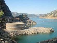
The dam's morning glory type spillway, known as the Glory Hole, is 72 feet (22 m) in diameter at lake level and narrows down to about 28 feet (8.5 m) at the exit. At the lake's peak level the spillway can drain 48,400 cubic feet per second (1,370 m3/s), which occurs when the lake level rises to 15.5 feet (4.7 m) above the level of the funnel.
Water spills over its lip when the lake reaches 1,602,000 acre feet (1.976×10⁹ m3) and a reservoir elevation of 440 feet (130 m) above sea level. The last time the reservoir spilled through the glory hole was on the morning of May 18, 2006. Current lake level status is available at Solano County Water Agency.
Swimming near the Glory Hole is prohibited.[14] The exit of the spillway is well known in the skateboarding world as a full-pipe. Emily Schwalen of Davis died in 1997 after swimming toward the Glory Hole and getting sucked down the pipe.[15]
See also
| Wikimedia Commons has media related to Monticello Dam. |
References
- 1 2 3 "Monticello Dam: Hydraulics & Hydrology". Solano Project. U.S. Bureau of Reclamation. 2010-05-26. Retrieved 2011-03-24.
- ↑ "Monticello (7646)". Carbon Monitoring for Action. Retrieved 2014-04-22.
- ↑ "Morning Glory Spillway". Davis Wiki. Retrieved 2014-04-23.
- ↑ "Monticello Dam Dimensions". Solano Project. U.S. Bureau of Reclamation. 2010-05-26. Retrieved 2014-04-22.
- ↑ "Berryessa Facts". U.S. Bureau of Reclamation. 2014-01-28. Retrieved 2014-04-22.
- 1 2 "Solano Project". U.S. Bureau of Reclamation. 2011-05-27. Retrieved 2014-04-22.
- 1 2 3 4 5 Redmond, Zachary (2000). "Solano Project" (PDF). U.S. Bureau of Reclamation. Retrieved 2014-04-22.
- ↑ Jensen, Peter (2012-08-19). "Death of Monticello was a 'heartbreaker', Part II: Rancher Recalls Life Before Lake Berryessa". Napa Valley Register. Retrieved 2014-04-22.
- 1 2 Kim, Chloe (2012-01-01). "Water works: Dam key to agricultural success". Davis Enterprise. Retrieved 2014-04-22.
- ↑ "The Monticello Dam Controversy and Lake Berryessa". Quail Ridge Reserve Human History. University of California Davis. 2005-07-05. Retrieved 2014-04-22.
- ↑ Sherwin, Elizabeth (1997-12-07). "Visit the lost town of Monticello in this photo essay". Davis Community Network. Retrieved 2014-04-22.
- ↑ "Lake Berryessa Map and Visitor Services" (PDF). U.S. Bureau of Reclamation. 2013-05-23. Retrieved 2014-04-22.
- ↑ Fimrite, Peter (2012-03-26). "Lake Berryessa residents face hefty utility fix". SFGate. Retrieved 2014-04-22.
- ↑ Antonio Martinez Ron. "The Largest Drain Hole in the World". Retrieved June 29, 2013.
- ↑ "Woman Sucked Into Lake Berryessa Spillway". San Francisco Chronicle. March 12, 1997. Retrieved June 29, 2013.