Royal Palace of El Pardo
| Royal Palace of El Pardo | |
|---|---|
|
Native name Spanish: Palacio Real de El Pardo | |
 | |
| Location | Madrid, Spain |
| Official name: Palacio Real de El Pardo | |
| Type | Non-movable |
| Criteria | Monument |
| Designated | 1931 |
| Reference no. | RI-51-0001062 |
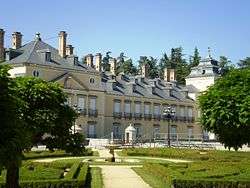

The Royal Palace of El Pardo (Spanish: Palacio Real de El Pardo) is a historic building near Madrid, Spain, in the present-day district of Fuencarral-El Pardo. It is owned by the Spanish state and administered by the Patrimonio Nacional agency.
Overview
The palace began as a royal hunting lodge. It became an alternative residence of the kings of Spain until the reign of Alfonso XII, who died in the palace in 1885.
King Enrique III of Castile ordered the building of the pavilion in 1406, on Mount El Pardo, because of its abundant game. Later, in the time of Emperor Carlos V (1547), it was transformed into a palace by the architect Luis de Vega. On 13 March 1604, a massive fire destroyed many of the paintings, including masterpieces by Titian. King Carlos III renovated the building in the 18th century, appointing his architect Francesco Sabatini to undertake the job. It was newly transformed in the 20th century, doubling in size with the construction of an identical copy of the original structure to the east.
The interior decoration includes a ceiling frescoed by Gaspar Becerra, and paintings by Vincenzo Carducci and Cabrera.
In 1739 the palace hosted talks between the governments of Britain and Spain, who eventually agreed to the Convention of Pardo in a bid to avert a war. However, the Convention failed to prevent war breaking out shortly afterwards.
Generalissimo Francisco Franco lived in the palace after the Spanish Civil War. Since Franco's death, it has been used as a residence for visiting heads of state.
The Palace of Zarzuela forms part of the complex of residences at the site.
See also
References
External links
![]() Media related to Royal Palace of El Pardo at Wikimedia Commons
Media related to Royal Palace of El Pardo at Wikimedia Commons
Coordinates: 40°31′19″N 3°46′28″W / 40.52194°N 3.77444°W
Royal sites in Spain | ||||||||||||
|---|---|---|---|---|---|---|---|---|---|---|---|---|
| Royal sites of the Patrimonio Nacional |
|  | ||||||||||
| Former Royal Palaces/residences1 |
| |||||||||||
1Particularly his section includes Medieval kingdoms's royal palaces, excludes any religious buildings, and excludes royal palaces in former territories or colonies | ||||||||||||