Mount Limbara
| Limbara | |
|---|---|
| Monti di Limbara, Monte ‘e Limbara | |
 Mount Limbara | |
| Highest point | |
| Peak | Punta Sa Berritta |
| Elevation | 1,362 m (4,469 ft) |
| Geography | |
| Country | Italy |
| State/Province | Sardinia |
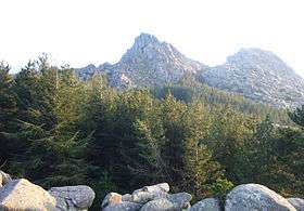
Mount Limbara (Gallurese: Monti di Limbara, Sardinian: Monte ‘e Limbara) is a rocky granitic massif in north-eastern Sardinia, Italy.
It is located in the geographical and historical region of Gallura.
Its highest peak is Punta Sa Berritta (1,362 m above sea level). Its area belongs to the comuni of Calangianus, Tempio Pausania, Berchidda and Oschiri, in the province of Olbia-Tempio.
History
The name could derive from the Latin Limes Balares ("Boundary of the Balares"), given it by the Romans as it marked the frontier with the territory still in the hands of the Balares, a late Nuragic tribe.
Mount Limbara was put to fire in 1936 and its woods made of cork oaks were replaced with pines, after a work of reforestation. After the World War II were planted forests of giant sequoias, too.
On the top of the massif was located a NATO U.S. Air Force Communications Relay Station and a Carabinieri's barrack. Today it is used as a telecommunications center for the Italian Air Force and a heliport for the Servizio Antincendi. It is also the location of all the major TV relay stations of West Sardinia.
Coordinates: 40°50′59″N 9°10′31″E / 40.84972°N 9.17528°E