Montdragon
| Montdragon | ||
|---|---|---|
|
Montdragon | ||
| ||
 Montdragon | ||
|
Location within Occitanie region  Montdragon | ||
| Coordinates: 43°46′30″N 2°06′13″E / 43.775°N 2.1036°ECoordinates: 43°46′30″N 2°06′13″E / 43.775°N 2.1036°E | ||
| Country | France | |
| Region | Occitanie | |
| Department | Tarn | |
| Arrondissement | Castres | |
| Canton | Lautrec | |
| Intercommunality | Lautrecois | |
| Government | ||
| • Mayor (2008–2014) | Roger Dauzats | |
| Area1 | 12.19 km2 (4.71 sq mi) | |
| Population (2006)2 | 579 | |
| • Density | 47/km2 (120/sq mi) | |
| Time zone | CET (UTC+1) | |
| • Summer (DST) | CEST (UTC+2) | |
| INSEE/Postal code | 81174 / 81440 | |
| Elevation |
159–302 m (522–991 ft) (avg. 190 m or 620 ft) | |
|
1 French Land Register data, which excludes lakes, ponds, glaciers > 1 km² (0.386 sq mi or 247 acres) and river estuaries. 2 Population without double counting: residents of multiple communes (e.g., students and military personnel) only counted once. | ||

.svg.png)
Montdragon is a commune in the Tarn department in southern France.
Geography
The commune is traversed by the river Dadou.

Map of Montdragon and its surrounding communes
Sites of interest
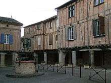
Timbered houses in the square
See also
References
| Wikimedia Commons has media related to Montdragon. |
This article is issued from Wikipedia - version of the 5/11/2015. The text is available under the Creative Commons Attribution/Share Alike but additional terms may apply for the media files.