Montappone
| Montappone | |
|---|---|
| Comune | |
| Comune di Montappone | |
 Montappone Location of Montappone in Italy | |
| Coordinates: 43°8′N 13°28′E / 43.133°N 13.467°ECoordinates: 43°8′N 13°28′E / 43.133°N 13.467°E | |
| Country | Italy |
| Region | Marche |
| Province / Metropolitan city | Province of Fermo |
| Area | |
| • Total | 10.4 km2 (4.0 sq mi) |
| Population (Dec. 2004) | |
| • Total | 1,780 |
| • Density | 170/km2 (440/sq mi) |
| Time zone | CET (UTC+1) |
| • Summer (DST) | CEST (UTC+2) |
| Postal code | 63020 |
| Dialing code | 0734 |
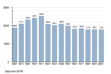
Montappone is a comune (municipality) in the Province of Fermo in the Italian region Marche, located about 50 kilometres (31 mi) south of Ancona and about 35 kilometres (22 mi) northwest of Ascoli Piceno. It is a very important centre for hat production.[1] As of 31 December 2004, it had a population of 1,780 and an area of 10.4 square kilometres (4.0 sq mi).[2]
Montappone borders the following municipalities: Falerone, Loro Piceno, Massa Fermana, Monte Vidon Corrado, Montegiorgio, Sant'Angelo in Pontano.
Demographic evolution
References
- ↑ http://www.italiantribune.com/the-hats-of-montappone/
- ↑ All demographics and other statistics: Italian statistical institute Istat.
This article is issued from Wikipedia - version of the 12/26/2015. The text is available under the Creative Commons Attribution/Share Alike but additional terms may apply for the media files.