Mont Pilat
| Mont Pilat | |
|---|---|
 Pilat viewed from Saint-Chamond, Loire | |
| Highest point | |
| Peak | Crêt de la Perdrix |
| Elevation | 1,432 m (4,698 ft) |
| Coordinates | 45°22′57″N 4°34′21″E / 45.382477°N 4.572537°ECoordinates: 45°22′57″N 4°34′21″E / 45.382477°N 4.572537°E |
| Geography | |
 Mont Pilat | |
| Country | France |
| Department | Rhône, Loire |
Mont Pilat or the Pilat massif is a mountainous area in the east of the Massif Central of France.
Name
The origin of the name "Pilat" is uncertain. The word may have a Latin origin (Mons Pileatus).[1] Another legend says that the body of Pontius Pilate was buried in the massif.[2]
For a long time Mont Pilat designated the main mountain, with the double peaks or crests (crêts) of Perdrix and Oeillon.[3] Modern maps generally designate this area as Les Crêts.[4] However, the Conseil supérieur de l'audiovisuel (CSA) continues to use the term Mont Pilat to refer to the television transmitter on the Crêt de l'Oeillon.[5]
The whole mountain range is commonly called Mont Pilat.[6][7] The Communauté de communes des Monts du Pilat coordinates various administrative and developmental functions for the communes in the massif.[8] The term Pilat is also used to refer to the area that became the Parc naturel régional du Pilat in 1974.[9]
Topography

The Pilat massif is part of the French Massif Central range. It lies in the extreme east of the range looking over the Rhone valley. The overall orientation of the massif is from south-west to north-east, creating a variety of climates. The massif generally rises about 1,000 metres (3,300 ft) above its surroundings. Perdrix (Partridge mountain) rises to 1,431 metres (4,695 ft) above sea level and Pyfara and Panère are 1,390 metres (4,560 ft) high.[10] Pilat is separated from the Monts du Lyonnais to the north by the Saint-Étienne basin, the Gier valley.[11]
The Gier rises at La Jasserie on the Perdrix mountain at about 1,300 metres (4,300 ft).[12] The river runs along the north side of the massif for 40.3 kilometres (25.0 mi) before joining the Rhone at Givors.[13] The Gier receives the Janon from its left at Saint-Chamond. The Janon from Terrenoire (now part of Saint-Étienne) to Saint-Chamond and then the Gier from Saint-Chamond to Givors create a valley in the coal basin that runs between the Pilat massif and the Riverie chain of the Monts du Lyonnais.[14]
Climate
Pilat has a wide variety of plants, reflecting different climate zones in a relatively small area. The Rhone valley on the south of the massif has a warm Mediterranean climate. Fruit trees and vineyards are cultivated on the south-facing slopes. On the north side there is a cooler continental climate, with conifers, juniper and ferns. There is heavy snow in the winter. On the crests, the altitude, winds and snow prevent the growth of trees. Vegetation includes heath plants such as heather and bilberry.
History

Flint and pottery found in the municipality of Saint-Genest-Malifaux show that humans were present in pre-historic times. During the Celtic era the Pilat was shared by two Celtic peoples, the Segusiavi and the Allobroges. They gave the region the name Pilat, meaning broad mountain (pi: mountain and lat: broad). The Celts also left many places of worship, arrangements of stones such as those at Château de Belize above Chuyer, the Rock Altar Roisey and La Garde, the sacred precincts of Saint-Sabin and the peak of the Three Teeth, and especially the "Menhir du Flat" near Colombier.
In Roman times the water of the river Gier was supplied to Lyon through the aqueduct of the Gier. The water was collected above Saint-Chamond and routed through tunnels, of which there are remains at Chagnon and Saint-Martin-la-Plaine, and aqueducts such as the one at Chaponost. During the Roman era Pilat formed the border between the provinces of Gallia Narbonensis and Gallia Lugdunensis. There are remains of Roman roads in places such as Pélussin and Saint-Régis-du-Coin.
On 1 November 1944 a U.S. Army Douglas C-47 Skytrain crashed due to bad weather carrying five crew members, army nurse lieutenant Aleda E. Lutz and fifteen wounded of whom some were German prisoners. There were no survivors. It took several hours for help to arrive. The crash occurred in the hollow of La Botte not far from La Jasserie, where a monument was raised in 2002 commemorating the accident.[15]
Administration
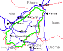
The Pilat is mostly located in the Loire department southeast of the city of Saint-Étienne and southwest of the cities of Vienne and Givors. The massif is bordered by the departments of Rhône, Isère, Ardèche and Haute-Loire.
The communes of the Communauté de communes des Monts du Pilat are Bourg-Argental, Burdignes, Colombier, Graix, Jonzieux, La Versanne, Le Bessat, Marlhes, Planfoy, Saint-Genest-Malifaux, Saint-Julien-Molin-Molette, Saint-Régis-du-Coin, Saint-Romain-les-Atheux, Saint-Sauveur-en-Rue, Tarentaise and Thélis-la-Combe.[16]
Attractions

Sainte-Croix-en-Jarez lies in northern Pilat. Once it was a fortified 13th century monastery, but after the French Revolution it became a village. The high country around the Crêt de la Perdrix and the Crêt de l'Œillon is popular for cross-country skiing in the winter.[6] The region is attractive to motorcyclists, with winding roads leading through bright valleys and deep forests, and with magnificent views of the Alps and the Massif Central.[7]
The Saut du Gier waterfall near the head of the Gier is in the Pilat Regional Natural Park.[17] It is a trickle in the summer, but a waterfall in autumn and spring.
The Pierre des Trois évêques (Three Bishops' Stone) is in the commune of Saint-Régis-du-Coin.[18] It marked the meeting point of three provinces of Roman Gaul: Lyon, Narbonne and Aquitaine. Under Charlemagne the stone marked the point where Aquitaine, Provence and Burgundy met, and was used as a reference point during the partition of the empire in 843 AD. In the Middle Ages it delineated the Archdioceses of Lyon, Vienna and Puys.[19]
The Pierre Saint-Martin (Saint Martin's Stone) is located near Mont Chaussitre. According to legend, Saint Martin of Tours left his mark here when he moved. Since then, according to local belief, the stone would be able to help young children to walk.
Gallery
 Crêt de l'Oeillon with the France Info antenna
 Crêt de la Bote
 Les trois dents (the three teeth)
 Lake Saint-Genest-Malifaux on the River Semene in winter
 Chapelle de Saint-Sabin above the village of Véranne
 Village of Malleval
References
Citations
- ↑ Dauzat 1978.
- ↑ Un peu d'histoire: Parc.
- ↑ Balbis 1828, p. 90.
- ↑ Les parcs naturels régionaux: Jaune et la Rouge.
- ↑ Chtcherbak 2013.
- 1 2 Barbour, Facaros & Pauls 2004, p. 682.
- 1 2 Auzias 2013, p. 394.
- ↑ Bienvenue: Communauté de communes.
- ↑ Le Pilat, un territoire remarquable.
- ↑ Centre d'études foréziennes 1979, p. 9.
- ↑ Vitel 2001, p. 15.
- ↑ Gruner 1857, p. 57.
- ↑ Gier: Sandre.
- ↑ Gruner 1857, p. 58.
- ↑ Aleda Ester Lutz.
- ↑ Les Communes: Communauté de communes.
- ↑ AAA 2002, p. 506.
- ↑ Vacher 2010, p. 115.
- ↑ Lodewijckx 2001, p. 19.
Sources
- AAA (2002-04-30). Bed & Breakfast in France. AAA. ISBN 978-1-56251-684-0. Retrieved 2013-08-19.
- "Aleda Ester Lutz" (PDF). Aleda E. Lutz VA Medical Center, Saginaw, Michigan. U.S. Department of Veterans Affairs. Retrieved 2013-08-21.
- Auzias, Dominique; Labourdette, Jean-Paul (2013-04-24). France à moto 2013 Petit Futé (avec cartes, photos + avis des lecteurs): Les 100 plus belles balades. Petit Futé. ISBN 978-2-7469-6645-1. Retrieved 2013-08-21.
- Balbis, Giovanni Battista (1828). Flore lyonnaise ou Description des plantes qui croissent dans les environs de Lyon et sur le Mont Pilat. imp. de C. Coque. p. 90. Retrieved 2013-08-21.
- Barbour, Philippe; Facaros, Dana; Pauls, Michael (2004). France. New Holland Publishers. p. 682. ISBN 978-1-86011-881-4. Retrieved 2013-08-21.
- "Bienvenue". Communauté de communes des Monts du Pilat. Retrieved 2013-08-21.
- Centre d'études foréziennes (1979). Le Pilat et ses abords. Université de Saint-Etienne. p. 9. ISBN 978-2-85145-037-1. Retrieved 2013-08-19.
- Chtcherbak, Mikhaïl (2013). "Les radios à Lyon". Radiomap. Retrieved 2013-08-21.
- Dauzat, Albert (1978). Dictionnaire étymologique des noms de rivières et de montagnes en France. Éditions Klincksieck. ISBN 978-2-252-01914-6. Retrieved 2013-08-21.
- "Gier". Sandre. Retrieved 2013-08-19.
- Gruner, Louis (1857). Description géologique et minéralogique du département de la Loire. Imprimerie impériale. Retrieved 2013-08-19.
- "Le Pilat, un territoire remarquable". Parc naturel régional du Pilat. Retrieved 2013-08-21.
- "Les Communes". Communauté de communes des Monts du Pilat. Retrieved 2013-08-21.
- "Les parcs naturels régionaux: Conciliation des objectifs de protection et de développement". La Jaune et la Rouge (566). June/July 2001. Retrieved 2013-08-21. Check date values in:
|date=(help) - Lodewijckx, Marc (2001-01-01). Belgian Archaeology in a European Setting. Leuven University Press. p. 19. ISBN 978-90-5867-166-0. Retrieved 2013-08-21.
- "Un peu d'histoire". Parc naturel régional du Pilat. Retrieved 2013-08-21.
- Vacher, Marguerite (2010). Nuns Without Cloister: Sisters of St. Joseph in the Seventeenth and Eighteenth Centuries. University Press of America. ISBN 978-0-7618-4342-9. Retrieved 2013-08-21.
- Vitel, Georges (2001). Géologie de la Loire: invitation à la lecture des paysages. Université de Saint-Etienne. ISBN 978-2-86272-206-1. Retrieved 2013-08-19.