Monroe City, Missouri
| Monroe City, Missouri | |
|---|---|
| City | |
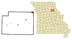 Location of Monroe City, Missouri | |
| Coordinates: 39°39′13″N 91°43′56″W / 39.65361°N 91.73222°WCoordinates: 39°39′13″N 91°43′56″W / 39.65361°N 91.73222°W | |
| Country | United States |
| State | Missouri |
| Counties | Monroe, Marion, Ralls |
| Government | |
| • Mayor | Neal Minor |
| Area[1] | |
| • Total | 3.06 sq mi (7.93 km2) |
| • Land | 3.02 sq mi (7.82 km2) |
| • Water | 0.04 sq mi (0.10 km2) |
| Elevation | 745 ft (227 m) |
| Population (2010)[2] | |
| • Total | 2,531 |
| • Estimate (2012[3]) | 2,485 |
| • Density | 838.1/sq mi (323.6/km2) |
| Time zone | Central (CST) (UTC-6) |
| • Summer (DST) | CDT (UTC-5) |
| ZIP code | 63456 |
| Area code(s) | 573 |
| FIPS code | 29-49394[4] |
| GNIS feature ID | 0729344[5] |
| Website | City website |
Monroe City is a city in Marion, Monroe, and Ralls counties in the U.S. state of Missouri. The population was 2,531 at the 2010 census.
The Marion and Ralls County portions of Monroe City are part of the Hannibal Micropolitan Statistical Area.
History
Monroe City was platted in 1856, and named for its location within Monroe County.[6] A post office called Monroe City has been in operation since 1860.[7]
Geography
Monroe City is located at 39°39′13″N 91°43′56″W / 39.65361°N 91.73222°W (39.653570, -91.732152).[8]
According to the United States Census Bureau, the city has a total area of 3.06 square miles (7.93 km2), of which 3.02 square miles (7.82 km2) is land and 0.04 square miles (0.10 km2) is water.[1]
Demographics
| Historical population | |||
|---|---|---|---|
| Census | Pop. | %± | |
| 1870 | 353 | — | |
| 1880 | 640 | 81.3% | |
| 1890 | 1,830 | 185.9% | |
| 1900 | 1,929 | 5.4% | |
| 1910 | 1,949 | 1.0% | |
| 1920 | 1,941 | −0.4% | |
| 1930 | 1,820 | −6.2% | |
| 1940 | 1,978 | 8.7% | |
| 1950 | 2,093 | 5.8% | |
| 1960 | 2,337 | 11.7% | |
| 1970 | 2,456 | 5.1% | |
| 1980 | 2,557 | 4.1% | |
| 1990 | 2,701 | 5.6% | |
| 2000 | 2,588 | −4.2% | |
| 2010 | 2,531 | −2.2% | |
| Est. 2015 | 2,446 | [9] | −3.4% |
2010 census
As of the census[2] of 2010, there were 2,531 people, 1,036 households, and 623 families residing in the city. The population density was 838.1 inhabitants per square mile (323.6/km2). There were 1,189 housing units at an average density of 393.7 per square mile (152.0/km2). The racial makeup of the city was 89.6% White, 7.3% African American, 0.4% Native American, 0.4% Asian, 0.2% from other races, and 2.1% from two or more races. Hispanic or Latino of any race were 1.5% of the population.
There were 1,036 households of which 33.5% had children under the age of 18 living with them, 43.5% were married couples living together, 13.0% had a female householder with no husband present, 3.6% had a male householder with no wife present, and 39.9% were non-families. 36.1% of all households were made up of individuals and 17.2% had someone living alone who was 65 years of age or older. The average household size was 2.35 and the average family size was 3.07.
The median age in the city was 37.9 years. 26.7% of residents were under the age of 18; 7.8% were between the ages of 18 and 24; 23.7% were from 25 to 44; 24.7% were from 45 to 64; and 17% were 65 years of age or older. The gender makeup of the city was 47.4% male and 52.6% female.
2000 census
As of the census[4] of 2000, there were 2,588 people, 1,061 households, and 661 families residing in the city. The population density was 837.1 people per square mile (323.4/km²). There were 1,182 housing units at an average density of 382.3 per square mile (147.7/km²). The racial makeup of the city was 89.34% White, 8.85% African American, 0.04% Native American, 0.15% Pacific Islander, 0.35% from other races, and 1.28% from two or more races. Hispanic or Latino of any race were 0.43% of the population.
There were 1,061 households out of which 31.6% had children under the age of 18 living with them, 47.1% were married couples living together, 11.7% had a female householder with no husband present, and 37.7% were non-families. 34.0% of all households were made up of individuals and 15.8% had someone living alone who was 65 years of age or older. The average household size was 2.35 and the average family size was 3.04.
In the city the population was spread out with 26.3% under the age of 18, 7.7% from 18 to 24, 25.2% from 25 to 44, 21.9% from 45 to 64, and 19.0% who were 65 years of age or older. The median age was 38 years. For every 100 females there were 84.9 males. For every 100 females age 18 and over, there were 80.5 males. o The median income for a household in the city was $30,377, and the median income for a family was $38,750. Males had a median income of $28,947 versus $20,114 for females. The per capita income for the city was $14,937. About 7.3% of families and 11.0% of the population were below the poverty line, including 10.4% of those under age 18 and 9.7% of those age 65 or over.
Notable residents
- Helen Cornelius, Country music singer-songwriter, actress. Born Monroe City, 1941.
- Belle Johnson, early photographer
- Claude Smith, instrumental music composer and educator. Created the official march of the National Air & Space Museum among other notable works.
- Henderson Forsythe, (1917–2006), American Actor
References
- 1 2 "US Gazetteer files 2010". United States Census Bureau. Retrieved 2012-07-08.
- 1 2 "American FactFinder". United States Census Bureau. Retrieved 2012-07-08.
- ↑ "Population Estimates". United States Census Bureau. Retrieved 2013-05-30.
- 1 2 "American FactFinder". United States Census Bureau. Retrieved 2008-01-31.
- ↑ "US Board on Geographic Names". United States Geological Survey. 2007-10-25. Retrieved 2008-01-31.
- ↑ "Monroe County Place Names, 1928–1945". The State Historical Society of Missouri. Archived from the original on June 24, 2016. Retrieved November 10, 2016.
- ↑ "Post Offices". Jim Forte Postal History. Retrieved 10 November 2016.
- ↑ "US Gazetteer files: 2010, 2000, and 1990". United States Census Bureau. 2011-02-12. Retrieved 2011-04-23.
- ↑ "Annual Estimates of the Resident Population for Incorporated Places: April 1, 2010 to July 1, 2015". Retrieved July 2, 2016.
- ↑ "Census of Population and Housing". Census.gov. Retrieved June 4, 2015.
External links
- City website
- Historic maps of Monroe City in the Sanborn Maps of Missouri Collection at the University of Missouri
Municipalities and communities of Marion County, Missouri, United States | ||
|---|---|---|
| Cities | 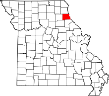 | |
| Townships | ||
| Unincorporated communities | ||
| Ghost towns | ||
| Footnotes | ‡This populated place also has portions in an adjacent county or counties | |
Municipalities and communities of Monroe County, Missouri, United States | ||
|---|---|---|
| Cities | 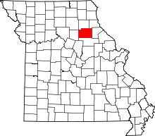 | |
| Villages | ||
| Townships | ||
| Unincorporated communities | ||
| Footnotes | ‡This populated place also has portions in an adjacent county or counties | |
Municipalities and communities of Ralls County, Missouri, United States | ||
|---|---|---|
| Cities | 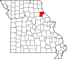 | |
| Village | ||
| Townships |
| |
| Unincorporated communities |
| |
| Ghost towns |
| |
| Footnotes | ‡This populated place also has portions in an adjacent county or counties | |