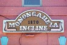
Monongahela Incline
| Monongahela Incline | |
|---|---|
 | |
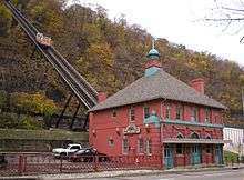 Lower Station of Monongahela Incline | |
| Overview | |
| Type | Incline |
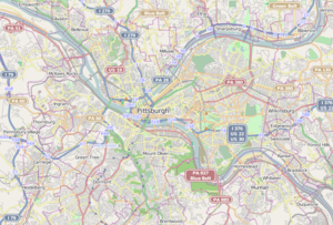
| Locale | Pittsburgh, Pennsylvania |
| Termini |
West Carson Street Grandview Avenue |
| Stations | 2 |
| Operation | |
| Opened | May 28, 1870 |
| Owner | Port Authority of Allegheny County |
| Technical | |
| Line length | 635 feet (194 m) |
| Track gauge | 5 ft (1,524 mm) |
| Electrification | 1935 |
| Operating speed |
6 mph (9.7 km/h) |
|
Monongahela Incline | |
   | |
| Location |
Grandview Avenue at Wyoming Avenue, Pittsburgh, Pennsylvania |
| Coordinates | 40°25′55″N 80°0′20″W / 40.43194°N 80.00556°WCoordinates: 40°25′55″N 80°0′20″W / 40.43194°N 80.00556°W |
| Area | 1 acre (0.40 ha) |
| Built | 1869 |
| Architect | John Endres |
| Architectural style |
|
| NRHP Reference # | 74001742[1] |
| Significant dates | |
| Added to NRHP | June 25, 1974 |
| Designated CPHS | March 15, 1974[2] |
| Designated PHLF | 1970[3] |
The Monongahela Incline, built by John Endres in 1870, is located near the Smithfield Street Bridge in Pittsburgh. It is the oldest continuously operating funicular in the United States. It is also one of two surviving inclines (the other is the nearby Duquesne Incline) from the original 17 passenger-carrying inclines built in Pittsburgh starting in the late 19th century. Its lower station is across the street from the Station Square shopping complex, and is easily accessible from the light rail system at the Station Square station.
History

Pittsburgh's expanding industrial base in 1860 created a huge demand for labor, attracting mainly German immigrants to the region. This created a serious housing shortage as industry occupied most of the flat lands adjacent to the river, leaving only the steep, surrounding hillsides of Mt. Washington or "Coal Hill" for housing. However, travel between the "hill" and other areas was hindered by a lack of good roads or public transport.
The predominantly German immigrants who settled on Mt. Washington, remembering the Seilbahns (cable cars) of their former country, proposed the construction of inclines along the face of Coal Hill. The result was the Monongahela Incline, which opened on May 28, 1870.[4] Earlier inclines were used to transport coal in the Pittsburgh area, including the Kirk Lewis incline on Mt. Washington and the Ormsby mine gravity plane in nearby Birmingham, later annexed to the city of Pittsburgh.
The Monongahela Incline is operated by the Port Authority of Allegheny County, which operates the rest of Pittsburgh's transit system. Transfers can be made between the incline and the light rail and buses.[5]
Statistics
- Length: 635 feet (194 m)
- Elevation: 369.39 feet (112.59 m)
- Grade: 35 degrees, 35 minutes
- Gauge: 5 ft (1,524 mm) broad gauge
- Speed: 6 mph (9.7 km/h)
- Passenger Capacity: 23 per car
- Opened: May 28, 1870
- Renovated: 1882 (with steel structure)
- Original steam power replaced with electricity: 1935
- Renovated: 1982-83 new track structure, cars and stations
- Renovated: 1994 upper, lower stations, restored cars, replaced electric motors and controls[6]
Gallery
 Interior of the lower station.
Ascending 
Descending  P. & L.E. Ry. Pittsburgh and Lake Erie Railroad station and the Monongahela Incline on Mt. Washington, c.1905
See also
References
- ↑ National Park Service (2010-07-09). "National Register Information System". National Register of Historic Places. National Park Service.
- ↑ "Local Historic Designations". Pittsburgh: Pittsburgh History & Landmarks Foundation. Retrieved 2011-08-09.
- ↑ "Historic Landmark Plaques 1968-2009" (PDF). Pittsburgh History and Landmarks Foundation. 2010. Retrieved 2011-08-05.
- ↑ Leherr, Dave (7 May 1977). "Inclines Rise to National Landmarks". Pittsburgh Post-Gazette. p. 9.
- ↑ "Inclines". Port Authority of Allegheny County. Retrieved March 20, 2016.
- ↑ "Monongahela and Duquesne Inclines". ASME. 11 May 1977.
External links
- Historic American Engineering Record (HAER) No. PA-226, "Monongahela Incline Plane", 28 photos, 36 data pages, 7 photo caption pages
- Lower Station from Google Maps Street View
- Upper Station from Google Maps Street View
| Light rail (List of stations) | ||
|---|---|---|
| Inclines (Historical list) | ||
| Buses and busways (List of routes) | ||
| Former lines | ||
| Other | ||
| Topics |   | |
|---|---|---|
| Lists by county |
| |
| Lists by city | ||
| Other lists | ||
| ||