York city walls
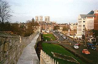
York has, since Roman times, been defended by walls of one form or another. To this day, substantial portions of the walls remain, and York has more miles of intact wall than any other city in England. They are known variously as York City Walls, the Bar Walls and the Roman walls (though this last is a misnomer as very little of the extant stonework is of Roman origin, and the course of the wall has been substantially altered since Roman times).
History
Roman walls
The original walls were built around 71 AD, when the Romans erected a fort (castra) occupying about 50 acres or 21.5 hectares near the banks of the River Ouse. The rectangle of walls was built as part of the fort's defences. The foundations and the line of about half of these Roman walls form part of the existing walls, as follows:
- a section (the west corner, including the Multangular Tower) in the Museum Gardens
- the north-west and north-east sections between Bootham Bar and Monk Bar
- a further stretch between Monk Bar and the Merchant Taylors' Hall, at the end of which the lower courses of the east corner of the Roman wall can be seen on the city-centre side of the existing wall.
The line of the rest of the Roman wall went south-west from the east corner, crossing the via principalis of the fortress where King's Square is now located. The south corner was in what is now Feasegate, and from here the wall continued northwest to the west corner. The point where the wall crossed the via praetoria is marked by a plaque in St Helen's Square near the Mansion House.
Multangular Tower

The Multangular Tower in the Museum Gardens is the most noticeable and intact structure remaining from the Roman walls. It was constructed as part of a series of eight similar defensive towers. The walls are almost certainly the creation of Septimius Severus; however, the Multangular Tower is probably a later addition of Constantine the Great around 310–320 AD. It has ten sides, based on a regular fourteen-sided figure designed so that a circle through the internal angles of the internal face is tangential to the curve.[1] The rear four sides are missing to provide access to the interior of the tower.
A low plinth or skirt extends out from the lowest course. It stands almost 30 feet (9.1 m) tall, has an external diameter of 48.5 feet (14.8 m) at the base and 46 feet (14 m) above the skirt.[1] Length of each side varies from 7.5 feet (2.3 m) to 11 feet (3.4 m) on the inner face.[1] The tower projects beyond the curtain wall to a distance of 36.75 feet (11.20 m).[1] The foundations are concrete, atop which the tower extends having a rubble and mortar core between ashlar faced courses of small magnesian limestone blocks.[1] At 15 feet (4.6 m) a scarcement reduces the thickness of the wall from 5 feet (1.5 m) to 3.25 feet (0.99 m), which continues for a further 4 feet (1.2 m) before being capped by 11 feet (3.4 m) of 13th century masonry[1] in which arrowslits can be seen.
After the Romans
The Danes occupied the city in 867. By this time the Roman defences were in poor repair, and the Danes demolished all the towers save the Multangular Tower and restored the walls.
The majority of the remaining walls, which encircle the whole of the medieval city, date from the 12th – 14th century, with some reconstruction carried out in the 19th century and later. From the east corner of the Roman walls, the medieval wall extends to Layerthorpe Bridge. After the bridge, the King's Fishpool, a swamp created by the Normans' damming of the River Foss, provided adequate security for the city, and no walls were ever built in this area.
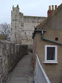
The walls resume beyond the now canalised Foss at the Red Tower, a brick building which has been much restored over the years. They continue south and west around the Walmgate area, terminating in another tower (Fishergate Postern), near York Castle, which was formerly surrounded by its own walls and a moat.
A small stretch of wall on the west side of Tower Gardens terminates at Davy Tower, another brick tower located next to the River Ouse. This originally ran up to the castle walls, with a postern on Tower Street.
Beyond the Ouse, the walls resume at Skeldergate, where there was once another postern. They climb past Baile Hill, take a right turn and proceed north-west parallel to the Inner Ring Road. Near the railway station, they turn right again in a north-easterly direction, finishing at Barker Tower on the Ouse.
Barker Tower was once linked by a chain across the river, parallel to the 19th-century Lendal Bridge. A small stretch of wall then leads to the entrance to Museum Gardens, the Multangular Tower and the original line of the Roman walls.
Today the walls are a scheduled ancient monument and a grade I listed building.[2]
Bars

The walls are punctuated by four main gatehouses, or 'bars', (Bootham Bar, Monk Bar, Walmgate Bar and Micklegate Bar below). These restricted traffic in medieval times, and were used to extract tolls, as well as being defensive positions in times of war.
Bootham Bar
Although much of Bootham Bar was built in the 14th and 19th centuries, it also has some of the oldest surviving stonework, dating to the 11th century. It stands almost on the site of porta principalis dextra, the north western gate of Eboracum. It was named in the 12th century as barram de Bootham, meaning bar at the booths, after the nearby market booths. It was the last of the bars to lose its barbican, which was removed in 1835.
Monk Bar


This four-storey gatehouse is the tallest and most elaborate of the four, and was built in the early 14th century. It was intended as a self-contained fort, and each floor is capable of being defended separately. The current gatehouse was built to replace a 12th-century gate known as Munecagate, which stood 100 yards (91 m) to the north-west, on the site of the Roman gate porta decumana – that location is indicated by a slight dip in the earth rampart.[3][4] Today, Monk Bar houses a Richard III Museum[5] and retains its portcullis in working order.
Walmgate Bar

Most of Walmgate Bar was built during the 14th century, although the inner gateway dates from the 12th century. It was originally called Walbegate, the word Walbe possibly being an Anglo-Scandinavian personal name. The Bar's most notable feature is its barbican, which is the only one surviving on a town gate in England. It also retains its portcullis and 15th century oak doors. On the inner side, an Elizabethan house, supported by stone Tuscan order columns (originally of Roman origin but modified in 1584), extends out over the gateway. The house was occupied until 1957.[6]
The Bar has been repaired and restored many times over the years, most notably in 1648, following the 1644 Siege of York in the English Civil War when it was bombarded by cannon fire, and in 1840 after it had suffered years of neglect. It was also damaged in 1489 when, along with Fishergate Bar, it was burnt by rebels who were rioting over tax raises.
Micklegate Bar


The name of this four-storey-high gatehouse is from the Old Norse 'mykla gata' or 'great street', and leads onto Micklegate ('gate' is Norwegian for 'street' remaining from Viking influence in York). It was the traditional ceremonial gate for monarchs entering the city, who, in a tradition dating to Richard II in 1389, touch the state sword when entering the gate.
A 12th-century gatehouse was replaced in the 14th century with a heavy portcullis and barbican. Its symbolic value led to traitors' severed heads being displayed on the defences. Heads left there to rot included: Henry Hotspur Percy (1403), Henry Scrope, 3rd Baron Scrope of Masham (1415), Richard Plantagenet, 3rd Duke of York (1461), and Thomas Percy, 7th Earl of Northumberland (1572).
The building was inhabited until the twentieth century. The upper two floors contain living quarters, which today are a museum of the bar, housing the "Henry VII Experience".[7]
Minor bars
Besides the four main bars, there are two smaller bars.
Fishergate Bar
This Bar originally dates from around 1315, when it was documented as being called Barram Fishergate.[8] It was bricked up following riots in 1489, but was reopened in 1827 and today provides pedestrian access through the walls between the Fishergate area (actually Fawcett Street/Paragon Street) and George Street.
Victoria Bar
As the name suggests, this bar is a 19th-century addition to the walls. It was opened in 1838 to provide direct access between Nunnery Lane and Bishophill. However, during its construction the remains of an ancient gateway were found beneath it. This was probably the gateway known in the 12th century as the lounelith or secluded gateway[9] (in comparison to Micklegate Bar or the great bar located four hundred yards away). This was a small entrance to the city which dated back to early medieval times but was blocked up later with earth and stone, possibly during the period when the walls consisted solely of a wooden palisade before they were rebuilt in stone (from around 1250).
See also
- List of town walls in England and Wales
- London wall
- Chester city walls
- History of York
- Eboracum
- Museum Gardens
- Siege of York
References
- 1 2 3 4 5 6 RCHME, 1962, Ebvuracum: Roman York (Royal Commission on Historical Monuments England) pp. 13–14
- ↑ "VR York, York City Wall". www.vryork.com. Archived from the original on 17 July 2007. Retrieved 19 March 2007.
- ↑ Wilson and Mee, p.53
- ↑ R.M. Butler (1974): The Bars and Walls of York (Yorkshire Architectural and York Archaeological Society), ISBN 978-0-9503519-0-2, pp. 5–6.
- ↑ Richart III Experience
- ↑ "Protection of Walmgate Bar" (PDF). City of York Council. 7 January 2004.
- ↑ "Henry VII Experience". York Archaeological Trust. 2012–2014. Retrieved 11 November 2014.
- ↑ "Archived copy". Archived from the original on 28 May 2011. Retrieved 3 September 2010.
- ↑ Wilson and Mee, p.36
Sources
- Pevsner, Nikolaus; Neave, David (1995) [1972]. Yorkshire: York and the East Riding (2nd ed.). London: Penguin Books. ISBN 978-0-14-071061-8.
- Wilson, Barbara; Mee, Frances (2005). The City Walls and Castles of York: The Pictorial Evidence. York Archaeological Trust. ISBN 978-1-874454-36-6.
External links
- City Walls info at City of York Council website
- The Friends of York Walls website
- Detailed Walking Tour of York Walls
- VR York – panoramic photos
- An in depth audio guide for the Walls
- City Bar walls photo site
- Index to several photos of the walls
- Street map showing plan of the walls
- The Walls theme on the History of York website
Coordinates: 53°57′19″N 1°04′52″W / 53.9553°N 1.0810°W