Monhegan, Maine
| Monhegan | |
|---|---|
| Plantation | |
| Plantation of Monhegan Island | |
|
Monhegan Harbor in 1909 | |
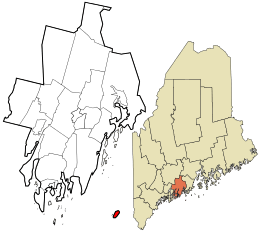 Location in Lincoln County and the state of Maine. | |
| Coordinates: 43°45′59″N 69°19′5″W / 43.76639°N 69.31806°W | |
| Country |
|
| State |
|
| County |
|
| Incorporated | 1839 |
| Area | |
| • Total | 4.5 sq mi (11.7 km2) |
| • Land | 0.9 sq mi (2.2 km2) |
| • Water | 3.7 sq mi (9.5 km2) |
| Elevation | 0 ft (0 m) |
| Population (2000) | |
| • Total | 75 |
| • Density | 87.5/sq mi (33.8/km2) |
| Time zone | Eastern (EST) (UTC-5) |
| • Summer (DST) | EDT (UTC-4) |
| ZIP code | 04852 |
| Area code(s) | 207 |
| FIPS code | 23-46335 |
| GNIS feature ID | 0582600 |
| U.S. NNL | Designated: 1966 |

Monhegan is a plantation in Lincoln County, Maine, United States, about 12 nautical miles (22 km) off the mainland. The population was 75 at the 2000 census. The plantation comprises its namesake island and the uninhabited neighboring island of Manana. The island is accessible by scheduled boat service from Boothbay Harbor, New Harbor and Port Clyde. It was designated a National Natural Landmark for its coastal and island flora in 1966.[1]
History
The name Monhegan derives from Monchiggon, Algonquian for "out-to-sea island." European explorers Martin Pring visited in 1603, Samuel de Champlain in 1604, George Weymouth in 1605 and Captain John Smith in 1614. The island got its start as a British fishing camp prior to settlement of the Plymouth Colony. Cod was harvested from the rich fishing grounds of the Gulf of Maine, then dried on fish flakes before shipment to Europe. A trading post was built to conduct business with the Indians, particularly in the lucrative fur trade.[2] It was Monhegan traders who taught English to Samoset, the sagamore who in 1621 startled the Pilgrims by boldly walking into their new village at Plymouth and saying: "Welcome, Englishmen." [3]
On April 29, 1717, Monhegan was visited by the Anne, a pirate ship of the snow type. The Anne had originally been captured off the Virginia Capes in April by the pirate Samuel Bellamy in the Whydah, which wrecked in a storm on the night of April 26, 1717, off of Cape Cod. The Anne made it through the storm with another captured vessel, the Fisher (which was soon abandoned and the pirates aboard her transferred to the Anne). The pirates, led by Pirate Bonita, arrived at Monhegan on April 29, and waited for the Whydah, for the pirates had not seen or heard about the Whydah wrecking in the storm of the night of April 26. The pirates eventually realized the Whydah was lost, and proceeded to attack vessels at Matinicus Island and Pemaquid (now Bristol). The pirates outfitted for their own uses a small 25-ton sloop that the pirates had captured off Matinicus, one that formerly belonged to Colonel Stephen Minot. They abandoned all the other vessels (including the Anne) they had captured and most of their prisoners at Matinicus on or about May 9, 1717, on Minot's sloop.[4]
Despite success as a fishing and trade center, Monhegan would be caught in the conflict between New England and New France for control of the region. During King Philip's War, dispossessed English settlers from the mainland sought refuge on the island before being relocated elsewhere along the coast. During King William's War, the island was captured for the French in 1689 by Baron de Saint-Castin. He destroyed the fishing fleet and burned the buildings, with many inhabitants escaping to Massachusetts. But even during periods when Monhegan was abandoned, its convenient offshore harbor remained a stopover destination for ships. The end of the French and Indian War in 1763 brought peace to the area, and on September 4, 1839, Monhegan was incorporated as an island plantation.[2]
In 1824, a conical stone lighthouse was built on the island by order of Congress and President James Monroe. Damaged by storms, it was replaced in 1850 by the present 48 foot (14.6 m) granite tower, with a fog bell station built in 1855 on nearby Manana Island. The island's 1,000 acres (400 ha) of good land encouraged agriculture, with potatoes the chief crop. But fishing was always the most important industry, whether locally or at the Grand Banks. Today, it still dominates Monhegan’s economy.[5] From October 1 through June, fishermen harvest lobsters from the only lobster conservation area in the state of Maine.[6]
Artist colony
The beginnings of the art colony on Monhegan date to the mid-19th century; by 1890, it was firmly established. Two of the early artists in residence from the 1890s, William Henry Singer (1868–1943) and Martin Borgord (1869–1935), left Monhegan to study at the Académie Julian in 1901. Among many early members who found inspiration on the island were summer visitors from the New York School of Art and the Pennsylvania Academy of the Fine Arts, such as Robert Henri, Frederick Waugh, George Bellows, Edward Hopper and Rockwell Kent.
Later members of the artist colony have included Jay Hall Connaway, Abraham Bogdanove, Andrew Winter, Reuben Tam, Frances Kornbluth, Elena Jahn and Jamie Wyeth.[7] The 150-foot (50 m) northside cliffs at Blackhead have drawn the interest of Monhegan artists, including Kent,[8] Hopper,[9] and Kornbluth.[10] The Monhegan Museum celebrated more the continuing draw of the island for artists in a 2014 exhibit entitled, “The Famous and the Forgotten: Revisiting Monhegan’s Celebrated 1914 Art Exhibition.”[11]
_painting_on_Monhegan_Island%2C_Maine.jpg) Artist painting fisherman en plein air at Fish Beach. Photo by Warner Taylor.
Artist painting fisherman en plein air at Fish Beach. Photo by Warner Taylor. Blackhead by Edward Hopper
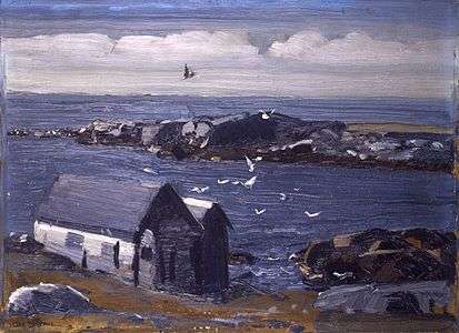 The Gulls, Mohegan by George Bellows
 1940s view of the main track in town by Sears Gallagher
Geography
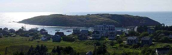
According to the United States Census Bureau, the island has a total area of 4.5 square miles (12 km2), of which 0.9 square miles (2.3 km2) of it is land and 3.7 square miles (9.6 km2) of it (80.97%) is water. Monhegan is an island 1.75 miles (2.82 km) long and .75 of a mile (1.2 kilometers) wide, located in the Gulf of Maine, part of the Atlantic Ocean. Adjacent Manana Island helps form Monhegan Harbor.
Demographics
| Historical population | |||
|---|---|---|---|
| Census | Pop. | %± | |
| 1830 | 67 | — | |
| 1840 | 77 | 14.9% | |
| 1870 | 145 | — | |
| 1880 | 133 | −8.3% | |
| 1890 | 90 | −32.3% | |
| 1900 | 94 | 4.4% | |
| 1910 | 120 | 27.7% | |
| 1920 | 133 | 10.8% | |
| 1930 | 109 | −18.0% | |
| 1940 | 115 | 5.5% | |
| 1950 | 75 | −34.8% | |
| 1960 | 65 | −13.3% | |
| 1970 | 44 | −32.3% | |
| 1980 | 109 | 147.7% | |
| 1990 | 88 | −19.3% | |
| 2000 | 75 | −14.8% | |
| 2010 | 69 | −8.0% | |
| Est. 2014 | 68 | [12] | −1.4% |
As of the census[14] of 2000, there were 75 people, 46 households, and 21 families residing in the plantation. The population density was 87.5 people per square mile (33.7/km²). There were 177 housing units at an average density of 206.4 per square mile (79.5/km²). The racial makeup of the plantation was 97.33% White and 2.67% Asian.
There were 46 households out of which 13.0% had children under the age of 18 living with them, 32.6% were married couples living together, 4.3% had a female householder with no husband present, and 54.3% were non-families. Of all households 47.8% were made up of individuals and 4.3% had someone living alone who was 65 years of age or older. The average household size was 1.63 and the average family size was 2.24.
In the plantation the population was spread out with 10.7% under the age of 18, 8.0% from 18 to 24, 29.3% from 25 to 44, 37.3% from 45 to 64, and 14.7% who were 65 years of age or older. The median age was 48 years. For every 100 females there were 127.3 males. For every 100 females age 18 and over, there were 116.1 males.
The median income for a household in the plantation was $26,250, and the median income for a family was $53,125. Males had a median income of $36,563 versus $13,333 for females. The per capita income for the plantation was $20,568. There were 10.5% of families and 3.8% of the population living below the poverty line, including 10.0% of under eighteens and none of those over 64.
Sites of interest and outdoor activities

Summer months bring artists and tourists on several daily ferries. Visitors arrive at the ferry landing or on a beach in the village precinct. The village includes a church, private homes, hotels, art studios, private homes for rent and a few small stores, including one that sells fresh fish/lobster. Much of Monhegan is uninhabited and open for exploration on 17 miles (27 km) of hiking trails,[15] which lead to high cliffs overlooking the sea. Inland paths lead through woods, including the Cathedral Woods.
The hill above the village is the site of the Monhegan Island Light, which offers a view of the village, the harbor, Mañana Island, and across the sea to the west. Adjacent to the lighthouse is the Monhegan Museum,[16] which is open middays from late June through September; the museum houses artifacts, reflecting the island's history.[17]
The island is on the Atlantic flyway and is a stopover for migrating birds and the birdwatchers who come seasonally to observe them.[17]
Education
In 2005, the Monhegan Island School had seven students, ages five through 12 (kindergarten through eighth grade), all taught by a single teacher;[18] high-school students must attend school on the mainland.[19] The schoolhouse reportedly also serves as a community center, which is site of the annual Christmas play and community dinner.[18]
Notable people
The following are people who have either resided on Monhegan or regularly visited the island:
- George Bellows, artist
- Abraham Bogdanove, artist
- Jon Bogdanove, comic book artist
- Tom and Kate Chappell, entrepreneurs
- Jay Hall Connaway, artist
- Lynne Drexler, artist
- Ernest Fiene, artist
- Sears Gallagher, artist
- Robert Henri, artist
- Edward Hopper, artist
- Eric Hudson, artist
- Wilson Irvine, artist
- Rockwell Kent, artist
- Josh Mostel, actor
- Frances Kornbluth, artist
- Zero Mostel, actor
- Remak Ramsay, actor
- Edward Redfield, artist
- Sonya Sklaroff, artist
- Frederick Waugh, artist
- Andrew Winter, artist
- Andrew Wyeth, artist
- Jamie Wyeth, artist
- N.C. Wyeth, artist
See also
- List of islands of Maine
- Rockwell Kent Cottage and Studio, also known as Kent-Fitzgerald Home
References
- ↑ "Monhegan Island". nps.gov. National Park Service.
- 1 2 Coolidge, Austin J.; John B. Mansfield (1859). A History and Description of New England. Boston, Massachusetts. pp. 211–212.
- ↑ Porter, Joseph W. (1888–1889). The Bangor Historical Magazine. 4. Bangor, Maine. pp. 81–83.
- ↑ "Deposition of Ralph Merry and Samuel Roberts" Boston. May 11, May 16, 1717. in Jameson, John Franklin. "Privateering and Piracy in the Colonial Period: Illustrative Documents." New York: Macmillan Company, 1923, pp. 301-302; "John Newman to Governor Shute" Gloucester. May 12, 1717. Massachusetts Archives 51:290
- ↑ Varney, George J. (1886), Gazetteer of the state of Maine. Monhegan, Boston: Russell
- ↑ 123rd Maine State Legislature (2007-06-04). "An Act To Provide Flexibility within the Monhegan Lobster Conservation Area and To Strengthen the Eligibility Requirements for a Student Lobster Fishing License" (PDF). HP1302, LR 2618, item 1. PUBLIC Law, Chapter 219 LD 1870, item 1. Retrieved 2012-07-24.
- ↑ Chambers, Bruce W. (2007). Maine: A Legacy in Painting, 1830 to the Present. Spanierman Gallery, LLC. ISBN 0-945936-73-7.
- ↑ Editor (1998). "A Painter of Monhegan". Rockwell Kent on Monhegan. Monhegan Museum. Retrieved 2015-02-16.
- ↑ Beem, Edgar Allen (2011). "Edward Hopper in Maine". Yankee Magazine. Retrieved 2015-02-16.
- ↑ Kornbluth, Frances (1985). "Ocean: A View of Blackhead". franceskornbluth.com. Retrieved 2015-02-16.
- ↑ Keyes, Bob (July 13, 2014). "Monhegan celebrates century of art, 400 years of settlement—An art show at the island museum re-creates a famous 1914 exhibition.". Lifestyle. Portland Press Herald. Retrieved 2015-02-16.
- ↑ "Annual Estimates of the Resident Population for Incorporated Places: April 1, 2010 to July 1, 2014". Retrieved June 4, 2015.
- ↑ "Census of Population and Housing". Census.gov. Retrieved June 4, 2015.
- ↑ "American FactFinder". United States Census Bureau. Retrieved 2008-01-31.
- ↑ Patricia Schultz, 1000 Places to see in the United States and Canada before you die Workman Publishing 2011 page 27
- ↑ Monhegan Museum
- 1 2 Editors (2014). "Attractions—Exploring Monhegan". Frommer's.
- 1 2 Ellis, Neenah (December 23, 2005). "Maine School Binds Isolated Island Together". America's One-Room Schools. National Public Radio. Retrieved 2014-01-11.
- ↑ Editors. "Penobscot Bay—Monhegan". Island Institute. Retrieved 2014-01-11.
Further reading
- Trotter, Bill Monhegan Prepares for Wind Power Bangor Daily News, Oct. 28, 2010
External links
| Wikimedia Commons has media related to Monhegan Island, Maine. |
Coordinates: 43°45′44″N 69°19′13″W / 43.76222°N 69.32028°W
Municipalities and communities of Lincoln County, Maine, United States | ||
|---|---|---|
| Towns |  | |
| Plantation | ||
| Gore | ||
| CDPs | ||
| Other villages | ||