Mondscheinspitze
| Mondscheinspitze | |
|---|---|
 Mondscheinspitze in wintertime | |
| Highest point | |
| Elevation | 2,106 m (6,909 ft) |
| Coordinates | 47°28′0″N 11°36′49″E / 47.46667°N 11.61361°ECoordinates: 47°28′0″N 11°36′49″E / 47.46667°N 11.61361°E |
| Geography | |
| Parent range | Alps, Karwendel |
| Climbing | |
| Easiest route | rock climb |

Mondscheinspitze is a summit of the Karwendel range in the Austrian state of Tyrol.
Though the name could be translated as Moonshine Peak, Mond originates from romance monticinu, which means small mountain meadow.[1]
Climbing
The Mondscheinspitze is the highest mountain in the Pre-Karwendel range. The summit can be reached from the Eng valley from the west or from the east from Pertisau. Both routes require alpine experience and are rated I or II by the alpine scale.[2]
References
- ↑ Georg Jäger: Vordeutsche Almnamen und alpwirtschaftliche Begriffe in Tirol (Teil I). In: Der Alm- und Bergbauer, Folge 6-7/01
- ↑ "https://translate.google.com/translate?hl=en&sl=de&u=http://www.tourentipp.de/de/touren/Montscheinspitze-Bergtour-Karwendel_249.html&prev=/search%3Fq%3DMondschein%2BSpitze%26sa%3DX%26rls%3Dcom.microsoft:en-us:IE-Address%26biw%3D1280%26bih%3D907". tourentipp.com. tourentipp.com. Retrieved 12 August 2014. External link in
|title=(help)
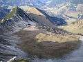 View from the summit to the plateau below with a small nameless lake
This article is issued from Wikipedia - version of the 11/13/2016. The text is available under the Creative Commons Attribution/Share Alike but additional terms may apply for the media files.