Mokroluški potok
| Mokroluški potok | |
|---|---|
 Stream's mouth | |
| Native name | Мокролушки поток |
| Country | Serbia |
| Basin | |
| Main source | Veliki Mokri Lug, east Belgrade, Serbia |
| River mouth |
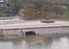
Sava, at Belgrade, Serbia 44°48′5.2632″N 20°26′30.7644″E / 44.801462000°N 20.441879000°ECoordinates: 44°48′5.2632″N 20°26′30.7644″E / 44.801462000°N 20.441879000°E |
| Physical characteristics | |
| Length | approx. 15 km (9.3 mi) |
The Mokroluški potok (Serbian Cyrillic: Мокролушки поток) is a stream in north-central Serbia, which forms a 15 km-long former right tributary to the Sava river. During its entire concourse, it runs through the urban section of Belgrade. It is one of the 40 rivers, streams and creeks that flow or used to flow through Belgrade, but the majority of them are conducted underground into the city sewage system which is also the case with Mokroluški potok.
The Mokroluški potok originates in Belgrade's eastern neighborhood of Veliki Mokri Lug, in the municipality of Zvezdara, which also gives the name to the stream (Mokri Lug stream). The Mokroluški potok flows generally in a north-west direction and its valley is used as a route for the Belgrade-Niš highway (constructed 1967-74). After it passes the cemetery of the neighboring Mali Mokri Lug, it reaches the neighborhood of Medaković III where the stream is conducted underground for the first time.
After an underground flow of about one kilometer, the stream resurfaces in the neighborhood of Medaković II, but one kilometer later, in the neighborhood of Marinkova Bara, it goes underground again. Formerly, it used to flow through the neighborhoods of Dušanovac, Autokomanda and Jatagan Mala. The area in the lower valley of the now underground stream was used for digging earth and gravel which were used to cover and drain the swamps on the Sava's right bank, so that neighborhoods of Savamala and Bara Venecija could be constructed, and for the building of Belgrade's central railway station. After the works were completed, the area around Mokroluški potok was left as a steep, elongated cut in the ground and so was given its present name (Prokop)