Mokokchung district
| Mokokchung district | |
|---|---|
| District | |
|
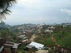
View of the district headquarters | |
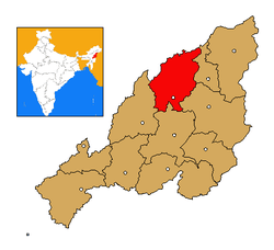 Mokokchung district's location in Nagaland | |
| Coordinates: 26°19′N 94°31′E / 26.317°N 94.517°ECoordinates: 26°19′N 94°31′E / 26.317°N 94.517°E | |
| State | Nagaland |
| Country | India |
| Seat | Mokokchung |
| Area | |
| • Total | 1,615 km2 (624 sq mi) |
| Population (2011) | |
| • Total | 193,171 |
| • Density | 120/km2 (310/sq mi) |
| Time zone | IST (UTC+05:30) |
| ISO 3166 code | IN-NL-MK |
| Website | http://mokokchung.nic.in/ |
Mokokchung (Pron:/ˌməʊkɒkˈtʃʌŋ/) is a district of Nagaland state in India. The town of Mokokchung is its headquarters. It is the home of the Ao Naga tribe. It covers an area of 1,615 km². It is bounded by the state of Assam to its north, Wokha district to its west, Tuensang and Longleng district to its east, and Zunheboto district to its south.
Geography
The physiography of the district shows six distinct hill ranges. The ranges are approximately parallel to each other and are aligned roughly north-east/south-west. The district lies between 94.29 and 94.76 degrees east longitude and 26.20 and 26.77 degrees north latitude. The entire district of Mokokchung is conveniently sub-divided into ranges. The main valleys are Tsurang, Changki and Milak Valleys. The district is agriculturally and industrially among the most progressive districts in the state, along with Dimapur and Kohima. Major agricultural regions are Changki-Longnak, Tsurang, Milak and Dikhu valley regions. Tuli-Milak region and Changki-Longnak valley are the major industrial areas.
Major mountain ranges
- Ongpangkong
- Asetkong
- Changkikong
- Japukong
- Langpangkong
- Tsurangkong
Land use
| Category | Area (km2) |
|---|---|
| Total land | 1615 |
| Forest Department purchased land | 49.66 |
| Agriculture | 180.39 |
| Villages and towns | 10.50 |
| Horticulture | 8.12 |
| Different development departments | 386.07 |
| Degraded land | 982.62 |
Administrative
Important urban centres
.jpg)
- Alichen-Mokokchung-DEF
- Tuli town
- Mangkolemba
- Changtongya
Largest villages (2001 census)
| Name | Population |
|---|---|
| Chuchuyimlang | 9,524 |
| Chuchuyimlang Village | 7,846 |
| Chuchuyimlang Compound | 1,678 |
| Changki | 7,718 |
| Ungma | 7,189 |
| Longjang | 7,005 |
Administrative towns
- Mokokchung
- Tuli
- Mangkolemba
- Changtongya
- Longchem
- Alongkima
- Kobulong
- Ongpangkong
- Chuchu town
Semi-urban settlements
- Alongtaki
- Waromung Compound
- Dibuia Compound
- Longjang Compound
- Mokokchung Compound
Divisions
The administrative headquarters of Mokokchung district is located at Mokokchung town and an Indian Administrative Service (IAS) Cadre, the Deputy Commissioner is the administrative head of the district. Mokokchung has three subdivisions: Tuli, Mangkolemba and Changtongya.
Politically, it is one of the most important districts in Nagaland. It sends 10 (of 60) legislators to the state assembly. Presently four of its legislators are in the ruling DAN government while the other six belong to Congress, the main opposition party in the state. Alichen-Mokokchung-DEF is the largest urban agglomeration area of the district.
Blocks
- Ongpangkong North
- Ongpangkong South
- Kobulong
- Changtongya
- Tuli
- Mangkolemba
Nagaland Legislative Assembly constituencies
- Alongtaki
- Jangpetkong
- Impur
- Angetyongpang
- Koridang
- Aonglenden
- Mokokchung town
- Mongoya
- Tuli
- Arkakong
Economy
Industrial regions
- Changki Valley
- Tsurang Valley
- Lower Milak-Tuli Region
- Dikhu-Chichung Valleys
Demographics
According to the 2011 census Mokokchung district has a population of 193,171,[1] roughly equal to the nation of Samoa.[2] This gives it a ranking of 591st in India (out of a total of 640).[1] Mokokchung has a sex ratio of 927 females for every 1000 males,[1] and a literacy rate of 92.68%.[1]
Christianity is the predominant religion with 95% of its population being Baptist. The district was the first to embrace Christianity in the later part of the 19th century and continues to be the Main Baptist belt of India. Impur, the centre of Ao Baptist Arogo Mungdang (ABAM), i.e. Ao Baptist Churches Convention, and the largest convention affiliated with the Nagaland Baptist Churches Convention, is located at the heart of the district.
The Jungli Ao is the main language of the Aos followed by Mongsen Ao language and Changki language.
Education
District's literacy rate of 84.6% (2001 census) is the highest in the state and one of the highest in the entire country. The district has been declared a fully literate district in 2007, to become Nagaland's first 100 percent literate district. With 1004 females for every 1000 males, it has the 7th healthiest sex ratio among the 538 districts of India in the 0-6 age group population (2001 census).
Private schools in Mokokchung District:
- English Kinder Garden School
- Model Higher Secondary School
- Edith Douglas School
- Queen Mary's School
- Jubilee Memorial School
- Hill View School
Colleges in Mokokchung:
- Clark Theological College
- Fazl Ali College
- People's College
- ICIT
- B.Ed College Yimyu
- Nagaland Bible College
Media
- All India Radio, Mokokchung
- Ao Milen (daily newspaper in Ao)
- Tir Yimyim (daily newspaper in Ao)
See also
- Natwar Thakkar, Gandhian social activist from Mokokchung district
References
- 1 2 3 4 "District Census 2011". Census2011.co.in. 2011. Retrieved 2011-09-30.
- ↑ US Directorate of Intelligence. "Country Comparison:Population". Retrieved 2011-10-01.
Samoa 193,161
External links
- Mokokchung District at National Informatics Center
- About Mokokchung
 |
Jorhat district, Assam | Sibsagar district, Assam | | |
| Wokha district | |
Longleng district | ||
| ||||
| | ||||
| Zunheboto district | Tuensang district |