Moel Cynghorion
| Moel Cynghorion | |
|---|---|
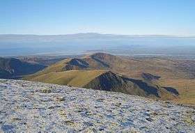 Moel Cynghorion with Moel Eilio behind from Crib y Ddysgl. | |
| Highest point | |
| Elevation | 674 m (2,211 ft) |
| Prominence | 176 m (577 ft) |
| Parent peak | Snowdon |
| Listing | Marilyn, Hewitt, Nuttall |
| Naming | |
| Translation | (bare/treeless) hill of counsels (Welsh) |
| Pronunciation | Welsh: [ˈmɔil kəŋˈhɔɾiɔn] |
| Geography | |
| Location | Gwynedd, Wales |
| Parent range | Snowdonia |
| OS grid | SH586563 |
| Topo map | OS Landranger 115 |
Moel Cynghorion (the Hill of the Councillors) is a mountain in Snowdonia, North Wales. It lies several miles north-west of Snowdon, and forms part of the Moel Eilio Horseshoe walk. The summit is situated on a wide plateau, marked by a pile of stones. The southern slopes are gentle, while the northern aspect is precipitous. The summit has close views of Clogwyn Du'r Arddu and Yr Wyddfa. Views from the summit can extend as far as Holyhead in Anglesey to nearby towns and villages in Gwynedd such as Caernarfon, Llanrug and Llanberis. On a clear day the Wicklow Mountains in Ireland can be seen across the Irish Sea, at a distance of approximately 80 miles away.[1][2][3]
References
- ↑ Marsh, Terry (1984). The Summits of Snowdonia (London: Robert Hale, 1984). ISBN 0-7090-1456-2.
- ↑ Marsh, Terry. The Mountains of Wales (London: Hodder and Stoughton, 1985). ISBN 0-340-34827-5.
- ↑ Nuttall, John & Anne (1999). The Mountains of England & Wales – Volume 1: Wales (2nd edition ed.). Milnthorpe, Cumbria: Cicerone. ISBN 1-85284-304-7.
External links
Coordinates: 53°05′07″N 4°06′46″W / 53.08514°N 4.11265°W
This article is issued from Wikipedia - version of the 1/24/2016. The text is available under the Creative Commons Attribution/Share Alike but additional terms may apply for the media files.