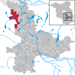
Mittenwalde
Mittenwalde is a town in the Dahme-Spreewald district, in Brandenburg, Germany. It is situated 30 km southeast of Berlin (centre).
On May 28, 1562 the town of Mittenwalde lent Berlin 400 guilders. The debt has never been repaid, though the town has attempted to collect the debt on rare occasion. The amount in 2012 would be about 112 million euros ($136.79 million), with simple interest. With compound interest the debt would be in the trillions of euros.[2]
Demography
Development of Population since 1875 within the Current Boundaries (Blue Line: Population; Dotted Line: Comparison to Population Development of Brandenburg state; Grey Background: Time of Nazi rule; Red Background: Time of Communist rule)
Recent Population Development (Blue Line) and Forecasts
Mittenwalde:
Population development within the current boundaries[3]
| Year |
Population |
|
|
|---|
| 1875 | 5 207 |
| 1890 | 6 869 |
| 1910 | 8 071 |
| 1925 | 7 902 |
| 1933 | 7 854 |
| 1939 | 9 461 |
| 1946 | 9 028 |
| 1950 | 9 076 |
| 1964 | 7 411 |
| 1971 | 7 195 |
|
|
| Year |
Population |
|
|
|---|
| 1981 | 6 224 |
| 1985 | 6 064 |
| 1989 | 5 800 |
| 1990 | 5 697 |
| 1991 | 5 584 |
| 1992 | 5 587 |
| 1993 | 5 576 |
| 1994 | 5 937 |
| 1995 | 6 522 |
| 1996 | 7 071 |
|
|
| Year |
Population |
|
|
|---|
| 1997 | 7 589 |
| 1998 | 7 877 |
| 1999 | 8 220 |
| 2000 | 8 410 |
| 2001 | 8 536 |
| 2002 | 8 547 |
| 2003 | 8 640 |
| 2004 | 8 699 |
| 2005 | 8 664 |
| 2006 | 8 684 |
|
|
| Year |
Population |
|
|
|---|
| 2007 | 8 663 |
| 2008 | 8 683 |
| 2009 | 8 710 |
| 2010 | 8 724 |
| 2011 | 8 658 |
| 2012 | 8 663 |
| 2013 | 8 734 |
|
|
References


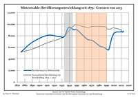 Development of Population since 1875 within the Current Boundaries (Blue Line: Population; Dotted Line: Comparison to Population Development of Brandenburg state; Grey Background: Time of Nazi rule; Red Background: Time of Communist rule)
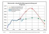 Recent Population Development (Blue Line) and Forecasts