Mirkot
| Mirkot Gorkha मिरकोट गोरखा | |
|---|---|
| Village Development Committee | |
|
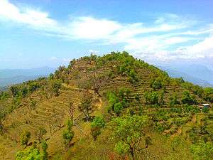
A hilly view of Mirkot. | |
 Mirkot Gorkha Location in Nepal | |
| Coordinates: 28°0′0″N 84°38′0″E / 28.00000°N 84.63333°ECoordinates: 28°0′0″N 84°38′0″E / 28.00000°N 84.63333°E | |
| Country |
|
| Region | Western |
| District | Gorkha District |
| Population (2011)A populated Place Of Gorkha District. | |
| • Total | 5,261 |
| Male 2407 & Female 2854 | |
| Time zone | Nepal Time (UTC+5:45) |
| Postal code | 34000 D.P.O. |
| Area code(s) | 064 |
| मिरकोट | Mirkot |
| Website | www.hamrogorkha.com |
| You can log on or subscribe on facebook.com/mirkotvdc | |
Mirkot ( मिरकोट ) is a village development committee in Gorkha District in the Gandaki Zone of northern-central Nepal. It lies on the western side of the headquarters of Gorkha. According to the National Population and Housing Census 2011, it had a population of 5261 (2407 male and 2854 female), and had 1388 households in the village. Its neighbourhood VDCs are Gaikhur, Dhuwakot, Khoplang, Chyangli, Palumtar, Chhoprak and Deurali. Such as Kotgadi, Lakang, Mahadev Temple are the most important places of Mirkot. The central part of Mirkot VDC is called Bagdanda, Where the main office of the VDC and Mirkot Higher Secondary School are located.[1]
Gallery
 Kotgadhi.
 Mirkot Village View.
 A Village of Mirkot VDC.
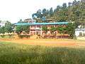 Mirkot School.
 Mahadev Temple, Mirkot.
 Lakang Kalika
References
- ↑ "National Population and Housing Census 2011". Nepal's Village Development Committees. Digital Himalaya. Archived from the original on 12 October 2011. Retrieved 2011-08-31.
See also


This article is issued from Wikipedia - version of the 9/14/2016. The text is available under the Creative Commons Attribution/Share Alike but additional terms may apply for the media files.