Minyar
| Minyar (English) Миньяр (Russian) | |
|---|---|
| - Town[1] - | |
 View of Minyar | |
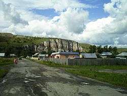
 Minyar | |
|
| |
.png) |
|
|
| |
| Administrative status (as of June 2014) | |
| Country | Russia |
| Federal subject | Chelyabinsk Oblast[1] |
| Administrative district | Ashinsky District[1] |
| Town | Minyar[1] |
| Administrative center of | Town of Minyar[1] |
| Municipal status (as of June 2014) | |
| Municipal district | Ashinsky Municipal District[1] |
| Urban settlement | Minyarskoye Urban Settlement[1] |
| Administrative center of | Minyarskoye Urban Settlement[2] |
| Statistics | |
| Population (2010 Census) | 10,194 inhabitants[3] |
| Time zone | YEKT (UTC+05:00)[4] |
| Founded | 1771 |
| Town status since | May 14, 1943 |
| Postal code(s)[5] | 456007, 456008 |
|
| |
| Minyar on Wikimedia Commons | |
Minyar (Russian: Минья́р) is a town in Ashinsky District of Chelyabinsk Oblast, Russia, located in the valley of the Sim River at its confluence with the Minyar River, 370 kilometers (230 mi) west of Chelyabinsk, the administrative center of the oblast. Population: 10,194 (2010 Census);[3] 11,032 (2002 Census);[6] 12,930 (1989 Census).[7]
History
It was founded in 1771. Town status was granted to it on May 14, 1943.
Administrative and municipal status
Within the framework of administrative divisions, it is, together with one rural locality (the settlement of Volkovo), incorporated within Ashinsky District as the Town of Minyar.[1] As a municipal division, the Town of Minyar is incorporated within Ashinsky Municipal District as Minyarskoye Urban Settlement.[1]
References
Notes
- 1 2 3 4 5 6 7 8 9 Resolution #161
- ↑ Федеральная служба государственной статистики. Федеральное агентство по технологическому регулированию и метрологии. №ОК 033-2013 1 января 2014 г. «Общероссийский классификатор территорий муниципальных образований. Код 75 609 103». (Federal State Statistics Service. Federal Agency on Technological Regulation and Metrology. #OK 033-2013 January 1, 2014 Russian Classification of Territories of Municipal Formations. Code 75 609 103. ).
- 1 2 Russian Federal State Statistics Service (2011). "Всероссийская перепись населения 2010 года. Том 1" [2010 All-Russian Population Census, vol. 1]. Всероссийская перепись населения 2010 года (2010 All-Russia Population Census) (in Russian). Federal State Statistics Service. Retrieved June 29, 2012.
- ↑ Правительство Российской Федерации. Федеральный закон №107-ФЗ от 3 июня 2011 г. «Об исчислении времени», в ред. Федерального закона №271-ФЗ от 03 июля 2016 г. «О внесении изменений в Федеральный закон "Об исчислении времени"». Вступил в силу по истечении шестидесяти дней после дня официального опубликования (6 августа 2011 г.). Опубликован: "Российская газета", №120, 6 июня 2011 г. (Government of the Russian Federation. Federal Law #107-FZ of June 31, 2011 On Calculating Time, as amended by the Federal Law #271-FZ of July 03, 2016 On Amending Federal Law "On Calculating Time". Effective as of after sixty days following the day of the official publication.).
- ↑ Почта России. Информационно-вычислительный центр ОАСУ РПО. (Russian Post). Поиск объектов почтовой связи (Postal Objects Search) (Russian)
- ↑ Russian Federal State Statistics Service (May 21, 2004). "Численность населения России, субъектов Российской Федерации в составе федеральных округов, районов, городских поселений, сельских населённых пунктов – районных центров и сельских населённых пунктов с населением 3 тысячи и более человек" [Population of Russia, Its Federal Districts, Federal Subjects, Districts, Urban Localities, Rural Localities—Administrative Centers, and Rural Localities with Population of Over 3,000] (XLS). Всероссийская перепись населения 2002 года [All-Russia Population Census of 2002] (in Russian). Retrieved August 9, 2014.
- ↑ Demoscope Weekly (1989). "Всесоюзная перепись населения 1989 г. Численность наличного населения союзных и автономных республик, автономных областей и округов, краёв, областей, районов, городских поселений и сёл-райцентров" [All Union Population Census of 1989: Present Population of Union and Autonomous Republics, Autonomous Oblasts and Okrugs, Krais, Oblasts, Districts, Urban Settlements, and Villages Serving as District Administrative Centers]. Всесоюзная перепись населения 1989 года [All-Union Population Census of 1989] (in Russian). Институт демографии Национального исследовательского университета: Высшая школа экономики [Institute of Demography at the National Research University: Higher School of Economics]. Retrieved August 9, 2014.
Sources
- Законодательное Собрание Челябинской области. Постановление №161 от 25 мая 2006 г. «Об утверждении перечня муниципальных образований (административно-территориальных единиц) Челябинской области и населённых пунктов, входящих в их состав», в ред. Постановления №2255 от 23 октября 2014 г. «О внесении изменений в перечень муниципальных образований (административно-территориальных единиц) Челябинской области и населённых пунктов, входящих в их состав». Вступил в силу со дня официального опубликования. Опубликован: "Южноуральская панорама", №111–112, 14 июня 2006 г. (Legislative Assembly of Chelyabinsk Oblast. Resolution #161 of November 25, 2006 On Adoption of the Registry of the Municipal Formations (Administrative-Territorial Units) of Chelyabinsk Oblast and of the Inhabited Localities They Comprise, as amended by the Resolution #2255 of October 23, 2014 On Amending the Registry of the Municipal Formations (Administrative-Territorial Units) of Chelyabinsk Oblast and of the Inhabited Localities They Comprise. Effective as of the official publication date.).
| Cities and towns | ||
|---|---|---|
| Districts | ||
| Urban-type settlements of oblast significance | ||
This article is issued from Wikipedia - version of the 9/22/2014. The text is available under the Creative Commons Attribution/Share Alike but additional terms may apply for the media files.