Minnesota statistical areas

The statistical areas of the United States of America comprise the metropolitan statistical areas (MSAs),[1] the micropolitan statistical areas (μSAs),[2] and the combined statistical areas (CSAs)[3] currently defined by the United States Office of Management and Budget (OMB).

Most recently on February 28, 2013, the Office of Management and Budget defined 1083 statistical areas for the United States,[4] including 4 combined statistical areas, 8 metropolitan statistical areas, and 16 micropolitan statistical areas in the State of Minnesota. The table below shows the recent population of these statistical areas and the 87 counties of Minnesota.
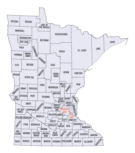
An enlargeable map of the 87 counties of the State of Minnesota

Table

The table below describes the 27 United States statistical areas and 87 counties of the State of Minnesota with the following information:[5]

  1. The combined statistical area (CSA) as designated by the OMB.[4]
  2. The CSA population as of July 1, 2013, as estimated by the United States Census Bureau.[6]
  3. The core based statistical area (CBSA)[7] as designated by the OMB.[4]
  4. The CBSA population as of July 1, 2013, as estimated by the United States Census Bureau.[6]
  5. The county name.[8]
  6. The county population as of July 1, 2013, as estimated by the United States Census Bureau.[8]
The 28 United States statistical areas and 87 counties of the State of Minnesota

Combined Statistical Area 2013 Population Core Based Statistical Area 2013 Population County 2013 Population
Minneapolis-St. Paul-St. Cloud, MN-WI CSA 3,796,341
3,670,977
Minneapolis-St. Paul-Bloomington, MN-WI MSA 3,457,634
3,332,270
Hennepin County, Minnesota 1,198,778
Ramsey County, Minnesota 526,714
Dakota County, Minnesota 408,509
Anoka County, Minnesota 339,534
Washington County, Minnesota 246,603
Scott County, Minnesota 137,232
Wright County, Minnesota 128,470
Carver County, Minnesota 95,562
Sherburne County, Minnesota 90,158
St. Croix County, Wisconsin 84,345
Chisago County, Minnesota 53,761
Pierce County, Wisconsin 41,019
Isanti County, Minnesota 37,816
Le Sueur County, Minnesota 27,810
Mille Lacs County, Minnesota 26,097
Sibley County, Minnesota 15,226
St. Cloud, MN MSA 190,543 Stearns County, Minnesota 152,092
Benton County, Minnesota 38,451
Faribault-Northfield, MN μSA 65,049 Rice County, Minnesota 65,049
Red Wing, MN μSA 46,464 Goodhue County, Minnesota 46,464
Hutchinson, MN μSA 36,651 McLeod County, Minnesota 36,651
none Duluth, MN-WI MSA 279,771
235,612
St. Louis County, Minnesota 200,226
Douglas County, Wisconsin 44,159
Carlton County, Minnesota 35,386
Rochester-Austin, MN CSA 230,152 Rochester, MN MSA 190,989 Olmsted County, Minnesota 149,226
Wabasha County, Minnesota 21,676
Fillmore County, Minnesota 20,866
Dodge County, Minnesota 20,087
Austin, MN μSA 39,163 Mower County, Minnesota 39,163
Mankato-New Ulm-North Mankato, MN CSA 124,148 Mankato-North Mankato, MN MSA 98,255 Blue Earth County, Minnesota 65,528
Nicollet County, Minnesota 32,727
New Ulm, MN μSA 25,893 Brown County, Minnesota 25,893
none Brainerd, MN μSA 94,775 Crow Wing County, Minnesota 66,208
Cass County, Minnesota 28,567
Fargo-Moorhead, ND-MN CSA 246,386
67,218
Fargo, ND-MN MSA 223,490
60,661
Cass County, North Dakota 162,829
Clay County, Minnesota 60,661
Wahpeton, ND-MN μSA 22,896
6,557
Richland County, North Dakota 16,339
Wilkin County, Minnesota 6,557
none Fergus Falls, MN μSA 57,581 Otter Tail County, Minnesota 57,581
Winona, MN μSA 51,232 Winona County, Minnesota 51,232
Bemidji, MN μSA 45,670 Beltrami County, Minnesota 45,670
Willmar, MN μSA 42,239 Kandiyohi County, Minnesota 42,239
Owatonna, MN μSA 36,576 Steele County, Minnesota 36,576
Alexandria, MN μSA 36,009 Douglas County, Minnesota 36,009
Grand Forks, ND-MN MSA 100,779
31,600
Grand Forks County, North Dakota 69,179
Polk County, Minnesota 31,600
Albert Lea, MN μSA 31,255 Freeborn County, Minnesota 31,255
Marshall, MN μSA 25,857 Lyon County, Minnesota 25,857
Worthington, MN μSA 21,378 Nobles County, Minnesota 21,378
Fairmont, MN μSA 20,840 Martin County, Minnesota 20,840
La Crosse, WI-MN MSA 133,665
19,027
La Crosse County, Wisconsin 114,638
Houston County, Minnesota 19,027
none Itasca County, Minnesota 45,058
Morrison County, Minnesota 33,198
Becker County, Minnesota 32,504
Pine County, Minnesota 29,750
Todd County, Minnesota 24,895
Meeker County, Minnesota 23,300
Hubbard County, Minnesota 20,428
Waseca County, Minnesota 19,136
Kanabec County, Minnesota 16,239
Aitkin County, Minnesota 16,202
Redwood County, Minnesota 16,059
Renville County, Minnesota 15,730
Roseau County, Minnesota 15,629
Faribault County, Minnesota 15,283
Pennington County, Minnesota 13,930
Wadena County, Minnesota 13,843
Koochiching County, Minnesota 13,311
Chippewa County, Minnesota 12,441
Cottonwood County, Minnesota 11,687
Watonwan County, Minnesota 11,211
Pope County, Minnesota 10,995
Lake County, Minnesota 10,866
Yellow Medicine County, Minnesota 10,438
Jackson County, Minnesota 10,266
Swift County, Minnesota 9,783
Stevens County, Minnesota 9,726
Rock County, Minnesota 9,687
Pipestone County, Minnesota 9,596
Marshall County, Minnesota 9,439
Murray County, Minnesota 8,725
Clearwater County, Minnesota 8,695
Lac qui Parle County, Minnesota 7,259
Norman County, Minnesota 6,852
Grant County, Minnesota 6,018
Lincoln County, Minnesota 5,896
Mahnomen County, Minnesota 5,413
Big Stone County, Minnesota 5,269
Cook County, Minnesota 5,176
Kittson County, Minnesota 4,552
Red Lake County, Minnesota 4,089
Lake of the Woods County, Minnesota 4,045
Traverse County, Minnesota 3,558
State of Minnesota 5,420,380

See also

References

  1. The United States Office of Management and Budget (OMB) defines a metropolitan statistical area (MSA) as a core based statistical area having at least one urbanized area of 50,000 or more population, plus adjacent territory that has a high degree of social and economic integration with the core as measured by commuting ties.
  2. The United States Office of Management and Budget (OMB) defines a micropolitan statistical area (μSA) as a core based statistical area having at least one urban cluster of at least 10,000 but less than 50,000 population, plus adjacent territory that has a high degree of social and economic integration with the core as measured by commuting ties.
  3. The United States Office of Management and Budget (OMB) defines a combined statistical area (CSA) as an aggregate of adjacent core based statistical areas that are linked by commuting ties.
  4. 1 2 3 "OMB Bulletin No. 13-01, Revised Delineations of Metropolitan Statistical Areas, Micropolitan Statistical Areas, and Combined Statistical Areas, and Guidance on Uses of the Delineations of These Areas" (PDF). United States Office of Management and Budget. February 28, 2013. Retrieved March 30, 2014.
  5. An out-of-state area and its population are displayed in green. An area that extends into more than one state is displayed in teal. A teal population number over a black population number show the total population versus the in-state population.
  6. 1 2 "Combined Statistical Area Totals Dataset: Population and Estimated Components of Change: April 1, 2010 to July 1, 2013" (CSV). 2013 Population Estimates. United States Census Bureau, Population Division. March 27, 2014. Retrieved March 30, 2014.
  7. The United States Office of Management and Budget (OMB) defines a core based statistical area as one or more adjacent counties or county-equivalents having at least one urban cluster of at least 10,000 population, plus adjacent territory that has a high degree of social and economic integration with the core as measured by commuting ties. The core based statistical areas comprise the metropolitan statistical areas and the micropolitan statistical areas.
  8. 1 2 "County Totals Dataset: Population, Population Change and Estimated Components of Population Change: April 1, 2010 to July 1, 2013" (CSV). 2013 Population Estimates. United States Census Bureau, Population Division. March 27, 2014. Retrieved March 30, 2014.
This article is issued from Wikipedia - version of the 4/24/2016. The text is available under the Creative Commons Attribution/Share Alike but additional terms may apply for the media files.