Milo Academy Bridge
|
Milo Academy Bridge | |
|
The bridge in 2008 | |
  | |
| Location | Milo, Oregon |
|---|---|
| Coordinates | 42°56′8″N 123°2′15″W / 42.93556°N 123.03750°WCoordinates: 42°56′8″N 123°2′15″W / 42.93556°N 123.03750°W |
| Area | 0.1 acres (0.040 ha) |
| Built | 1962 |
| MPS | Oregon Covered Bridges TR |
| NRHP Reference # | 79002055[1] |
| Added to NRHP | November 29, 1979 |
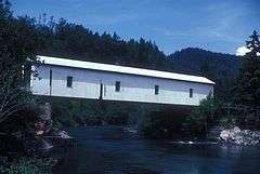
The Milo Academy Bridge, is a covered bridge over South Umpqua Creek, located in Milo, Oregon, United States. The bridge was constructed in 1962 and was added to the National Register of Historic Places on November 29, 1979. It is named for the Milo Adventist Academy.[2]
See also
- List of bridges on the National Register of Historic Places in Oregon
- National Register of Historic Places listings in Douglas County, Oregon
References
- ↑ National Park Service (2010-07-09). "National Register Information System". National Register of Historic Places. National Park Service.
- ↑ Cockrell, Bill; Nick Cockrell. "South Umpqua River (Milo Academy) Covered Bridge" (PDF). Roofs Over Rivers. Oregon State Library. Retrieved December 30, 2013.
| Lists by county |   | |
|---|---|---|
| Portland lists | ||
| Other lists |
| |
This article is issued from Wikipedia - version of the 11/30/2016. The text is available under the Creative Commons Attribution/Share Alike but additional terms may apply for the media files.