Millinocket, Maine
| Millinocket, Maine | ||
|---|---|---|
| Town | ||
|
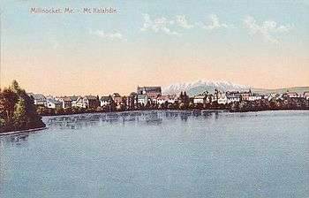
Millinocket, on the Penobscot River. | ||
| ||
 Millinocket, Maine Location within the state of Maine | ||
| Coordinates: 45°39′29″N 68°42′1″W / 45.65806°N 68.70028°W | ||
| Country | United States | |
| State | Maine | |
| County | Penobscot | |
| Settled | 1829 | |
| Incorporated | March 16, 1901 | |
| Area[1] | ||
| • Total | 18.22 sq mi (47.19 km2) | |
| • Land | 15.95 sq mi (41.31 km2) | |
| • Water | 2.27 sq mi (5.88 km2) | |
| Elevation | 351 ft (107 m) | |
| Population (2010)[2] | ||
| • Total | 4,506 | |
| • Estimate (2012[3]) | 4,447 | |
| • Density | 282.5/sq mi (109.1/km2) | |
| Time zone | Eastern (EST) (UTC-5) | |
| • Summer (DST) | EDT (UTC-4) | |
| ZIP code | 04462 | |
| Area code(s) | 207 | |
| FIPS code | 23-45810 | |
| GNIS feature ID | 0582596 | |
| Website |
www | |

Millinocket is a town in Penobscot County, Maine, United States.
The population was 4,506 at the 2010 census.[4] Millinocket's economy has historically been centered on forest products and recreation, but many area paper mills have closed in recent years.
History
Millinocket was first settled in 1829 by Thomas Fowler and his family, who cleared land for a farm. When the Bangor and Aroostook Railroad extended service to Houlton in 1894, the line ran through the area, opening it to development.

Charles W. Mullen, an engineering graduate from the University of Maine, proposed a hydroelectric dam on the Penobscot River. He recognized the falls as an ideal water power source to operate a large pulp and paper mill. Mullen contacted Garret Schenck, vice-president of the International Paper mill at Rumford Falls and an expert in the industry, about building a pulp and paper mill near the dam. Mr. Schenck agreed, and set about obtaining the necessary financial backing.[5]


After securing land rights, the chosen site was at the junction of the West Branch of the Penobscot River and Millinocket Stream, where it stands today. Things moved quickly, and on May 15, 1899, construction began on the new Great Northern Paper Company paper mill. As the location was not near existing towns, it became necessary to build one. Millinocket, meaning "the land of many islands" after all the islands in the Penobscot River, was incorporated on March 16, 1901.[6]
Garret Schenck contracted bonded labor, especially stonemasons from Italy. The term "bonded" in this case referred to the fact that the Italians owed for the passage to America and were in debt the minute they set foot in this country. Italian masons were largely responsible for the construction of the Millinocket mill.[6]
Throughout the 20th century, the community prospered. It developed a reputation as a small but successful rural town, mostly due to the paper industry, but also to its proximity to Katahdin, Maine's tallest mountain, and Moosehead Lake, Maine's largest lake.
In early 2003, however, Great Northern Paper announced it had filed for bankruptcy protection for its Millinocket and East Millinocket mills. Since then, the mill town has struggled to reshape its economy, while receiving significant help from the state government and local economic development efforts. Shortly after closing the mills, a Canadian corporation purchased the bankrupt paper mills in both Millinocket and East Millinocket. Currently, the paper mill employs over 200 workers in East Millinocket Mill only. In addition to the traditional forest products industry, Millinocket has been growing a service economy, and has grown into a major four-season tourist attraction. The region is served by the Millinocket Municipal Airport, which sells both 100LL avgas and jet fuel.[7]
Geography
According to the United States Census Bureau, the town has a total area of 18.22 square miles (47.19 km2), of which, 15.95 square miles (41.31 km2) of it is land and 2.27 square miles (5.88 km2) is water.[1]
The town is crossed by State Route 11 and 157. The town of East Millinocket is located 8 miles (13 km) to the east. Millinocket is the closest town to Mount Katahdin, located in Baxter State Park 20 miles (32 km) to the northwest. At an elevation 5,270 feet (1,610 m), its summit is the highest point in Maine.
Millinocket Lake
| Millinocket Lake | |
|---|---|
 Millinocket Lake near the town, with Mount Katahdin beyond. | |
| Max. length | 5 mi (8.0 km)[8] |
| Surface area | 8,571 acres (3,469 ha)[9] |
| Max. depth | 86 ft (26 m)[10] |
| Water volume | 179,982 acre·ft (222,005,000 m3)[9] |
| Surface elevation | 478 ft (146 m)[8] |
Millinocket Lake is 9 miles (14 km) northwest of town, and is drained by Millinocket Stream, which flows through the town of Millinocket into the West Branch Penobscot River 2 miles (3.2 km) south of town. The lake is fed by Sandy Stream, which drains the southeastern slopes of Mount Katahdin by tributaries including Roaring Brook, Avalanche Brook, Spring Brook, Beaver Brook, and Rum Brook.[8] Sandy Stream is a good spawning habitat for rainbow smelt, which are a primary prey for lake trout and land-locked Atlantic salmon living in the lake.[10]
Sites of interest
- Antique Snowmobile Museum [11]
- Baxter State Park
- Katahdin Woods and Waters National Monument
- Millinocket Historical Society & Museum [12]
- Millinocket Lake
- West Branch of the Penobscot River
Climate
This climatic region is typified by large seasonal temperature differences, with warm to hot (and often humid) summers and cold (sometimes severely cold) winters. According to the Köppen Climate Classification system, Millinocket has a humid continental climate, abbreviated "Dfb" on climate maps.[13]
| Climate data for Millinocket, Maine | |||||||||||||
|---|---|---|---|---|---|---|---|---|---|---|---|---|---|
| Month | Jan | Feb | Mar | Apr | May | Jun | Jul | Aug | Sep | Oct | Nov | Dec | Year |
| Record high °F (°C) | 57 (14) |
62 (17) |
70 (21) |
87 (31) |
96 (36) |
96 (36) |
97 (36) |
100 (38) |
92 (33) |
82 (28) |
71 (22) |
61 (16) |
100 (38) |
| Average high °F (°C) | 23 (−5) |
28 (−2) |
37 (3) |
51 (11) |
64 (18) |
73 (23) |
78 (26) |
77 (25) |
68 (20) |
55 (13) |
42 (6) |
30 (−1) |
52.2 (11.4) |
| Average low °F (°C) | 3 (−16) |
6 (−14) |
16 (−9) |
30 (−1) |
41 (5) |
51 (11) |
57 (14) |
55 (13) |
46 (8) |
35 (2) |
27 (−3) |
13 (−11) |
31.7 (−0.1) |
| Record low °F (°C) | −35 (−37) |
−42 (−41) |
−23 (−31) |
−3 (−19) |
20 (−7) |
32 (0) |
40 (4) |
32 (0) |
22 (−6) |
15 (−9) |
−5 (−21) |
−26 (−32) |
−42 (−41) |
| Average precipitation inches (mm) | 2.96 (75.2) |
2.58 (65.5) |
2.93 (74.4) |
3.52 (89.4) |
3.84 (97.5) |
4.01 (101.9) |
4.19 (106.4) |
3.95 (100.3) |
3.89 (98.8) |
4.34 (110.2) |
4.30 (109.2) |
3.52 (89.4) |
44.03 (1,118.2) |
| Source: weather.com[14] | |||||||||||||
Demographics
| Historical population | |||
|---|---|---|---|
| Census | Pop. | %± | |
| 1910 | 3,368 | — | |
| 1920 | 4,528 | 34.4% | |
| 1930 | 5,830 | 28.8% | |
| 1940 | 6,223 | 6.7% | |
| 1950 | 5,890 | −5.4% | |
| 1960 | 7,453 | 26.5% | |
| 1970 | 7,742 | 3.9% | |
| 1980 | 7,567 | −2.3% | |
| 1990 | 6,956 | −8.1% | |
| 2000 | 5,203 | −25.2% | |
| 2010 | 4,506 | −13.4% | |
| Est. 2014 | 4,401 | [15] | −2.3% |
2010 census
As of the census[2] of 2010, there were 4,506 people, 2,167 households, and 1,305 families residing in the town. The population density was 282.5 inhabitants per square mile (109.1/km2). There were 2,586 housing units at an average density of 162.1 per square mile (62.6/km2). The racial makeup of the town was 97.7% White, 0.2% African American, 0.7% Native American, 0.4% Asian, 0.1% Pacific Islander, 0.1% from other races, and 0.8% from two or more races. Hispanic or Latino of any race were 0.5% of the population.
There were 2,167 households of which 19.3% had children under the age of 18 living with them, 48.4% were married couples living together, 8.7% had a female householder with no husband present, 3.1% had a male householder with no wife present, and 39.8% were non-families. 34.2% of all households were made up of individuals and 17.1% had someone living alone who was 65 years of age or older. The average household size was 2.06 and the average family size was 2.58.
The median age in the town was 51.5 years. 15.5% of residents were under the age of 18; 5.5% were between the ages of 18 and 24; 17.8% were from 25 to 44; 36.6% were from 45 to 64; and 24.6% were 65 years of age or older. The gender makeup of the town was 48.6% male and 51.4% female.
2000 census
As of the census[17] of 2000, there were 5,203 people, 2,295 households, and 1,556 families residing in the town. The population density was 327.5 people per square mile (126.4/km²). There were 2,679 housing units at an average density of 168.6 per square mile (65.1/km²). The racial makeup of the town was 98.52% White, 0.10% Black or African American, 0.54% Native American, 0.37% Asian, 0.02% from other races, and 0.46% from two or more races. Hispanic or Latino of any race were 0.23% of the population.
There were 2,295 households, out of which 25.7% had children under the age of 18 living with them, 55.7% were married couples living together, 9.1% had a female householder with no husband present, and 32.2% were non-families. 28.3% of all households were made up of individuals and 14.5% had someone living alone who was 65 years of age or older. The average household size was 2.25 and the average family size was 2.69.
In the town the population was spread out with 21.1% under the age of 18, 4.9% from 18 to 24, 25.0% from 25 to 44, 29.7% from 45 to 64, and 19.4% who were 65 years of age or older. The median age was 44 years. For every 100 females there were 93.9 males. For every 100 females age 18 and over, there were 90.5 males.
The median income for a household in the town was $29,318, and the median income for a family was $40,893. Males had a median income of $41,218 versus $23,289 for females. The per capita income for the town was $17,130. About 11.8% of families and 14.8% of the population were below the poverty line, including 20.4% of those under age 18 and 12.4% of those age 65 or over.
Education
Schools in Millinocket are under the jurisdiction of the Millinocket School Department. The town's primary school is the Granite Street School, the middle school is Millinocket Middle School, and the secondary school is Stearns High School.[18]
Media
Newspaper
Millinocket has one traditional newspaper and one online newspaper which serve the area:
- Lincoln News, a weekly newspaper, distributed each Thursday, which offers a Millinocket section.
- Magic City Morning Star, which has published online since 2002.
Regionally, the Bangor Daily News is also circulated throughout the area.
Radio
The area is served by several radio stations, mainly Millinocket-licensed WSYY-FM The Mountain 94.9 (broadcasting for approximately 18¼ hours per day (from 4:55AM through 11:10PM ET), under the slogan, "Radio With An Attitude") and WSYY 1240 offers CBS Sports Radio as "CBS Sports Radio for the Katahdin Area" from Dawn until Dusk (ET). As an Adult Hits/Full-Service radio station, WSYY-FM airs a Classic Hits/Adult Contemporary/Classic Rock/Oldies/Contemporary Pop Music/Today's Hot New Country format, airing the format for approximately 16 hours per day, from 6:00AM through 10:00PM ET (reserving the first and, also, the final hour of their broadcast day to When Radio Was).[19] Stations from Bangor and the more powerful stations from Presque Isle are also heard.
Television
Millinocket is currently home to the Discovery Channel TV show American Loggers which showcases the logging efforts of Gerald Pelletier Incorporated. The television show, when in season, is on Friday nights at 10:00 PM Eastern/Pacific.[20] Cable television is provided by Bee Line Cable, which provides most of the network affiliates from Bangor.[21]
In popular culture
Millinocket is an important setting in several chapters of Maine writer Van Reid’s first novel Cordelia Underwood, or the Marvelous Beginnings of the Moosepath League. The novel takes place in July 1896 and combines elements of adventure, mystery, romance, and comedy with occasional undertones of the supernatural. It is the first novel in Reid’s well-received The Moosepath Saga and was named a New York Times Notable Book of the Year in 1998.
Millinocket is the setting for Bluebird (2013 film).
One of Bert & I's stories asked the question "Which way to Millinocket?"
Notable people
- Herbert E. Clark, state legislator
- Harry A. Corey, entrepreneur, Canadian politician
- Mary Kathryn Gonya, Miss Maine (1966)
- Jane Harragan, Miss Maine (1950)
- Mike Michaud, Member of the United States House of Representatives
- Andrew St. John, actor
- Joe Whalen, tennis player
References
- 1 2 "US Gazetteer files 2010". United States Census Bureau. Retrieved 2012-12-16.
- 1 2 "American FactFinder". United States Census Bureau. Retrieved 2012-12-16.
- ↑ "Population Estimates". United States Census Bureau. Retrieved 2013-07-06.
- ↑ "Geographic Identifiers: 2010 Demographic Profile Data (G001): Millinocket town, Penobscot County, Maine". U.S. Census Bureau, American Factfinder. Retrieved November 20, 2012.
- ↑ History of Millinocket, Maine
- 1 2 "Brief History of Millinocket, Maine," Millinocket Historical Society
- ↑ "Area History", Katahdin Area Chamber of Commerce
- 1 2 3 The Maine Atlas and Gazeteer (Thirteenth ed.). Freeport, Maine: DeLorme Mapping Company. 1988. pp. 43&51. ISBN 0-89933-035-5.
- 1 2 Maine Depts. of Environmental Protection and Inland Fisheries & Wildlife (2005-08-04). "Maine Lakes: Morphometry and Geographic Information". Senator George J. Mitchell Center for Environmental and Watershed Research, The University of Maine. Retrieved 2008-07-31.
- 1 2 "Millinocket Lake" (PDF). Maine Department of Inland Fisheries and Wildlife. State of Maine. Retrieved 11 May 2016.
- ↑ Antique Snowmobile Museum
- ↑ Millinocket Historical Society & Museum
- ↑ Climate Summary for Millinocket, Maine
- ↑ "Monthly Averages for Millinocket, Maine". Weather.com. The Weather Channel. Retrieved August 15, 2013.
- ↑ "Annual Estimates of the Resident Population for Incorporated Places: April 1, 2010 to July 1, 2014". Retrieved June 4, 2015.
- ↑ "Census of Population and Housing". Census.gov. Retrieved June 4, 2015.
- ↑ "American FactFinder". United States Census Bureau. Retrieved 2008-01-31.
- ↑ Millinocket page on GreatSchools
- ↑ "When Radio Was ("Find A Local Station")". RadioSpirits.com.
- ↑ American Loggers on Discovery
- ↑ Bee Line Cable - Digital Cable TV - Central Maine
External links
| Wikimedia Commons has media related to Millinocket, Maine. |
- Official Town of Millinocket website
- Millinocket Memorial Library
- Millinocket Historical Society & Museum
- Jo Mary Riders Snowmobile Club
- Northern Timber Cruisers Snowmobile Club
- Katahdin Regional Wiki: Millinocket
- What Happened To Lieutenant Hare?
- Katahdin Area Chamber of Commerce
Coordinates: 45°39′26″N 68°42′37″W / 45.65722°N 68.71028°W
