Millington, Maryland
| Millington, Maryland | |
|---|---|
| Town | |
 Location of Millington, Maryland | |
| Coordinates: 39°15′34″N 75°50′19″W / 39.25944°N 75.83861°WCoordinates: 39°15′34″N 75°50′19″W / 39.25944°N 75.83861°W | |
| Country | United States |
| State | Maryland |
| Counties | Kent, Queen Anne's |
| Area[1] | |
| • Total | 0.69 sq mi (1.79 km2) |
| • Land | 0.67 sq mi (1.74 km2) |
| • Water | 0.02 sq mi (0.05 km2) |
| Elevation | 20 ft (6 m) |
| Population (2010)[2] | |
| • Total | 642 |
| • Estimate (2012[3]) | 636 |
| • Density | 958.2/sq mi (370.0/km2) |
| Time zone | Eastern (EST) (UTC-5) |
| • Summer (DST) | EDT (UTC-4) |
| ZIP code | 21651 |
| Area code(s) | 410443 |
| FIPS code | 24-52825 |
| GNIS feature ID | 0585893 |
Millington is a town in Kent and Queen Anne's counties in the U.S. state of Maryland. The population was 642 at the 2010 census. Millington is the head of navigation for the Chester River.
History
The John Embert Farm was listed on the National Register of Historic Places in 1980.[4]
Geography
Millington is located at 39°15′34″N 75°50′19″W / 39.25944°N 75.83861°W (39.259355, -75.838666).[5]
According to the United States Census Bureau, the town has a total area of 0.69 square miles (1.79 km2), of which 0.67 square miles (1.74 km2) is land and 0.02 square miles (0.05 km2) is water.[1]
Climate
The climate in this area is characterized by hot, humid summers and generally mild to cool winters. According to the Köppen Climate Classification system, Millington has a humid subtropical climate, abbreviated "Cfa" on climate maps.[6]
Demographics
| Historical population | |||
|---|---|---|---|
| Census | Pop. | %± | |
| 1860 | 306 | — | |
| 1870 | 420 | 37.3% | |
| 1880 | 444 | 5.7% | |
| 1890 | 485 | 9.2% | |
| 1900 | 406 | −16.3% | |
| 1910 | 399 | −1.7% | |
| 1920 | 368 | −7.8% | |
| 1930 | 371 | 0.8% | |
| 1940 | 307 | −17.3% | |
| 1950 | 356 | 16.0% | |
| 1960 | 408 | 14.6% | |
| 1970 | 474 | 16.2% | |
| 1980 | 546 | 15.2% | |
| 1990 | 409 | −25.1% | |
| 2000 | 416 | 1.7% | |
| 2010 | 642 | 54.3% | |
| Est. 2015 | 617 | [7] | −3.9% |
2010 census
As of the census[2] of 2010, there were 642 people, 234 households, and 174 families residing in the town. The population density was 958.2 inhabitants per square mile (370.0/km2). There were 256 housing units at an average density of 382.1 per square mile (147.5/km2). The racial makeup of the town was 72.0% White, 13.9% African American, 3.0% Asian, 9.3% from other races, and 1.9% from two or more races. Hispanic or Latino of any race were 13.9% of the population.
There were 234 households of which 37.2% had children under the age of 18 living with them, 50.4% were married couples living together, 17.1% had a female householder with no husband present, 6.8% had a male householder with no wife present, and 25.6% were non-families. 17.1% of all households were made up of individuals and 4.7% had someone living alone who was 65 years of age or older. The average household size was 2.74 and the average family size was 2.95.
The median age in the town was 36.2 years. 22.6% of residents were under the age of 18; 11.5% were between the ages of 18 and 24; 29.2% were from 25 to 44; 27.8% were from 45 to 64; and 9% were 65 years of age or older. The gender makeup of the town was 48.6% male and 51.4% female.
2000 census
As of the census[9] of 2000, there were 416 people, 163 households, and 106 families residing in the town. The population density was 1,294.7 people per square mile (501.9/km²). There were 173 housing units at an average density of 538.4 per square mile (208.7/km²). The racial makeup of the town was 87.02% White, 6.49% African American, 4.33% from other races, and 2.16% from two or more races. Hispanic or Latino of any race were 7.69% of the population.
There were 163 households out of which 31.9% had children under the age of 18 living with them, 49.7% were married couples living together, 9.8% had a female householder with no husband present, and 34.4% were non-families. 28.2% of all households were made up of individuals and 13.5% had someone living alone who was 65 years of age or older. The average household size was 2.55 and the average family size was 3.07.
In the town the population was spread out with 26.0% under the age of 18, 7.2% from 18 to 24, 29.8% from 25 to 44, 21.4% from 45 to 64, and 15.6% who were 65 years of age or older. The median age was 37 years. For every 100 females there were 91.7 males. For every 100 females age 18 and over, there were 100.0 males.
The median income for a household in the town was $45,893, and the median income for a family was $48,750. Males had a median income of $29,917 versus $28,500 for females. The per capita income for the town was $20,240. About 8.6% of families and 12.9% of the population were below the poverty line, including 23.1% of those under age 18 and none of those age 65 or over.
References
- 1 2 "US Gazetteer files 2010". United States Census Bureau. Retrieved 2013-01-25.
- 1 2 "American FactFinder". United States Census Bureau. Retrieved 2013-01-25.
- ↑ "Population Estimates". United States Census Bureau. Retrieved 2013-06-26.
- ↑ National Park Service (2010-07-09). "National Register Information System". National Register of Historic Places. National Park Service.
- ↑ "US Gazetteer files: 2010, 2000, and 1990". United States Census Bureau. 2011-02-12. Retrieved 2011-04-23.
- ↑ Climate Summary for Millington, Maryland
- ↑ "Annual Estimates of the Resident Population for Incorporated Places: April 1, 2010 to July 1, 2015". Retrieved July 2, 2016.
- ↑ "Census of Population and Housing". Census.gov. Retrieved June 4, 2015.
- ↑ "American FactFinder". United States Census Bureau. Retrieved 2008-01-31.
External links
- Map of Millington, from the Historical Society of Kent County collection
Municipalities and communities of Kent County, Maryland, United States | ||
|---|---|---|
| Towns | 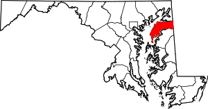 | |
| CDPs | ||
| Unincorporated communities | ||
| Footnotes | ‡This populated place also has portions in an adjacent county or counties | |
Municipalities and communities of Queen Anne's County, Maryland, United States | ||
|---|---|---|
| Towns |  | |
| CDPs | ||
| Other communities | ||
| Footnotes | ‡This populated place also has portions in an adjacent county or counties | |