Miguel Hidalgo, Mexico City
| Miguel Hidalgo | |
|---|---|
|
Polanco district in Miguel Hidalgo | |
 Location of Miguel Hidalgo in Mexico City | |
| State | [[]] |
| Area | |
| • Total | 26.96 sq mi (69.8 km2) |
| Population | |
| • Total | 372,889 |
| • Density | 14,000/sq mi (5,300/km2) |
| Website | http://www.miguelhidalgo.gob.mx |

Miguel Hidalgo is one of the 16 delegaciones (boroughs) into which Federal District of Mexico City is divided. It was created in 1970, joining the historic areas of Tacuba, Chapultepec and Tacubaya along with a number of notable neighborhoods such as Polanco and Lomas de Chapultepec. With landmarks such as Chapultepec Park and the Museo Nacional de Antropología, it is the second most visited borough in Mexico City after Cuauhtémoc, D.F. where the historic center of Mexico City is located. Tacubaya and Tacuba both have long histories as independent settlements and were designated as “Barrios Mágicos” by the city for tourism purposes.[1][2]
Geography and environment
The borough is located in the northwest Federal District of Mexico City, just west of the historic center. The borough is divided into eighty one neighborhoods called colonias. The largest of these is Bosques de las Lomas at 3.2km2, and the smallest is Popo Ampliación with only .33km2. It is bordered by the boroughs of Azcapotzalco, Cuauhtémoc, Benito Juárez, Álvaro Obregón and Cuajimalpa with the State of Mexico bordering it on the west side. It has a territory of 47.68km2 which is 3.17 percent of the total Federal District.[3]
The borough consists of an area which used to the west bank of Lake Texcoco, with three major zones, Tacuba, Chapultepec and Tacubaya. The geography of the borough includes canyons, hills and mesas associated with the Sierra de las Cruces, most present in the southwest bordering Cuajimalpa. In the northeast, mostly defined by the Circuit Interior road, is the most important elevation, the Cerro de Chapultepec at 2,260masl.[3] The area today is almost completely developed with green spaces mostly limited to parks. The largest green space is Chapultepec Park at 2.2 km2.[3] Parque Lineal was the former rail line of the Ferrocarril de Cuernavaca. The strip was converted into a park in 2011. Where the park crosses Lago Constanza Street in Colonia Anáhuac, there are often cultural events held.[4] One of the newest parks in the borough is located on Lago Caneguin in Colonia Argentina, created over a former roadway called Ruta 100. The unnamed park has 10,000 meters of surface area, kiosk, gymnasium, bicycle path, multipurpose room, parking, rain water containment system and child care center. It serves about 40,000 area residents.[5] In 2008, reforestation efforts were undertaken, beginning at the Cañitas Park.[6] While there were important rivers here such as Remedios, today there are no longer any free flowing currents of water. The climate is semi moist and temperate with annual rainfall varying between 700 and 800mm. The average annual temperature is 15C with lows in the winter about 8C and highs around 19C.[3]
Certain areas of the borough have problems with the stability of the ground due to old abandoned underground mines.[7] These areas include the América, Daniel Garza, 16 de Septiembre, Daniel Garza Apliación and Observatorio neighborhoods, which are particularly affected, but the problem also is found in El Capulín, Monte Sol and Ex Hacienda de Pedregal.[8] The number of people living in these areas is estimated at over 25,000, and about 500 families living in very high risk areas.[7] Abandoned mines have also been detected in Tacubaya, Lomas Altas, Bosque de las Lomas and even under Chapultepec Park.[8]
Demographics and socioeconomics

As of 2005, the borough had 106,005 residences of which 25,308 were freestanding houses, 54,079 were apartments and the rests of other types. This total number grew to a total of 123,910. About eighty percent of homes are owned by their residents and not rented. Around 95% have basic services such as electricity and running water. While the borough contains mostly working class areas in and around Tacuba and Tacubaya, the southwest contains some of the most exclusive colonias of the borough.[3] While most of the borough is residential, the population of the borough has dropped from 650,497 in 1960 to 372,889 in 2010. It is now the twelfth most densely occupied borough of sixteen. Just over eighty eight percent identify themselves as Catholic.[3]
The borough has 112 preschools, 160 primary schools, 79 middle schools, seven vocational/technical high schools and 49 high schools. The borough has an educational program called “Faros del Saber” (Lighthouses of Knowledge), which began in 2001. There are nine installations related to the program: each dedicated to a different field, such as ecology and science and technology, and each designed to promote these fields to the youth of the borough through workshops and various events. The main library of the program is part of CONACULTA and is designed to promote reading. The borough also offers classes to youth and adults in basic computer technology.[3]
Main thoroughfares include Paseo de la Reforma, Calzada México Tacuba, the Anillo Periférico, Avenida V Palmas and Avenida Constituyentes. Numerous bus and Metro lines pass through here, with the major transportation hub centered in Metro Tacubaya, where Lines 1, 7 and 9 converge. The borough is also home to the Observatorio bus station, which mostly serves buses heading west to Toluca and other destinations.[3][9]
The working population is 45.4% of the total. Overall socioeconomic marginalization of the borough is ranked very low.[3] The borough is the second most visited by tourists in Mexico City according to the Secretary of Tourism of the Federal District, receiving just under 13% of total visitors in 2006. The borough has nineteen major hotels, and five of the six best hotels in the city. Its major, upscale restaurants and entertainment centers are located in Polanco and Lomas de Chapultepec. Five star hotels include the Presidente Intercontinental, the Marriott and Niko, all located on Paseo de la Reforma next to Chapultepec Park. Commercial centers include eighteen traditional markets, the upscale shopping corridor along Avenida Presidente Masarik in Polanco and various malls.[3]
Bases for unlicensed taxis and areas crowded with unregulated street vendors is a major problem, especially around Christmas time. Most street-vending occurs in the Tacuba, Tacubaya, Chapultepec, Argentinas, Lomas and Polanco neighborhoods.[10] A number of stationary public markets have problems with abandoned stalls. This is occurs in the Tacuba, Anáhuac Anexo, Anáhuac Zone and El Chorrito markets. The main reason that these markets struggle is competition from supermarkets, but the deterioration of the buildings is another factor.[11]
History

The borough is named after Miguel Hidalgo y Costilla, who began the Mexican War of Independence .[3] The borough was created by fusing various former municipalities such as Tacuba, Tacubaya and the Chapultepec Park area along with the neighborhoods such as Polanco, Lomas de Chapultepec, Bosques de las Lomas, Popotla, Las Pensil, La Argentina, America, Santa Julia and Observatorio. The center of the borough is considered to be Chapultepec Park.[12]
Until the 20th century, Tacuba, Chapultepec and Tacubaya had separate histories, all part of the Federal District of Mexico City during most of this entity’s existence under various arrangements. In 1899, the Federal District was divided into the municipality of Mexico and six prefectures, one of which was Tacubaya. This arrangement was reconfirmed in 1917. In 1928, the Federal District was reorganized as a department under the direct control of the federal government. The territory was reorganized into Mexico City proper and thirteen boroughs: Guadalupe-Hidalgo, Azcapotzalco, Iztacalco, General Anaya, Coyoacán, San Ángel, La Magdalena Contreras, Cuajimalpa, Tlalpan, Iztapalapa, Xochimilco, Milpa Alta and Tláhuac. The city proper was divided into twelve districts. What is now Miguel Hidalgo, was part of Mexico City proper. In 1970, the city area was subdivided into four parts, Cuauhtémoc, Venustiano Carranza, Benito Juárez and Miguel Hidalgo.[12]

The various political arrangements to the present day have been a result of the growth of Mexico City proper. Tacuba, Chapultepec and Tacubaya in the pre Hispanic period were located on the western shore of Lake Texcoco, just west of the island where the Aztecs established Tenochtitlan. After the Spanish conquest of the Aztec Empire, the Spanish established their capital in Tenochtitlan, renaming it Mexico City. Constant flooding problems, almost forced the Spanish to move the capital to Tacubaya in the early 17th century; however, it was decided to drain and fill in the lake instead. This effort would extend over the colonial period and well after Independence. Drainage of the lake would create land on which Mexico City grew.[13]
At the beginning of the 20th century, the very edge of Mexico City has reached the villages of Tacuba and Tacubaya. During the first third of this century, the country estates, farmland and ranches between Tacuba, Tacubaya and Mexico City proper were turned into subdivisions for housing, with roads and other paved areas taking over empty fields. From the 1930s, population growth and development increased with the establishment of industrial and commercial areas. In the 1940s, the Polanco area between Chapultepec and Santa Julia was developed. Various public and private enterprises were installed along the avenues of Ejército Nacional and Marina Nacional. The Secretary of Defense made its home at Lomas de Sotelo. On the far west of the borough large cemeteries such as Panteón Francés, General Sancturum, Panteón Inglés and Panteón Español were opened.[12] One reason for the westward expansion was that wealthy families were abandoning the historic center of Mexico City for newer areas. This began with areas such as Colonia Roma and Condesa, but later they would move to Polanco. This movement west still continues into the Lomas area.[13]
Chapultepec

The center of the borough is Chapultepec Park. Chapultepec Park, more commonly called the "Bosque de Chapultepec" (Chapultepec Forest) in Mexico, is the largest city park in Latin America, measuring in total just over 686 hectares.[14][15][16]
The area has been considered special since long in the pre Hispanic period when it was a ceremonial site and later a retreat for Aztec emperors. There is also evidence of settlements here by the Chichimecas and Toltecs. The Mexicas lived here at before they were expelled by Azcapotzalco. After finally establishing Tenochtitlan, the Mexicas or Aztecs considered Chapultepec sacred. The first aqueduct from there to Tenochtitlan/Mexico City was built by Moctezuma Ilhuicamina. Later Moctezuma Xocoyotzin had fish tanks and gardens constructed on the site. And Nezahualcoyotl had a palace constructed at the base of the hill.[12] After the Conquest, Hernán Cortés tried to take this land for himself but Charles V denied this and made the area the heritage of Mexico City because it contained many of the springs that provided the city with potable water. The second and third sections of Chapultepec were opened in 1962 and 1974 respectively, with the third section from part of the lands which were an old paper factory.[12]
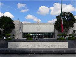
The two most important museums are the Museo Nacional de Antropología and the Chapultepec Castle National History Museum.[3] These and most of the rest of the museums in the first section are located along Paseo de la Reforma.[17] Of all of the museums in the park, the most famous is the Museo Nacional de Antropología, considered to be one of the greatest archeological museums in the world.[18] The museum has a number of antecedents beginning from the colonial period, but the current institution was created in the 1960s with the building and grounds designed by architect Pedro Ramírez Vázquez. This museum has an area of 44,000m2 and 25 exhibit halls with sections devoted to each of the major pre-Hispanic civilizations in Mexico including the Aztec, Maya, Toltec and Olmec.[18][19] The permanent collection is so large, that it is possible to spend an entire day to see it. There are also temporary exhibits as well.[18]
The Castle of Chapultepec is on Chapultepec Hill on which the park is historically centered. Construction of this castle was begun in the 1780s and includes towers and merlons, not for defense, but to give the structure a more royal feel. In 1847, the Castle was the scene of the Battle of Chapultepec and the suicide of the “Niños Héroes” or Boy Heroes. A monument to these boys is located at the foot of Chapultepec Hill.[20] From the 19th in to the 20th centuries, this structure was used as the official residence of Mexico’s heads of state until this was changed to Los Pinos in the 1930s. Residents included Maximiliano I of Mexico, who had Paseo de la Reforma, which passes through Chapultepec Park, built to connect the area with the center of the city. Today, it is home to the National History Museum.[12]
Other features of the park include the Chapultepec Zoo, two artificial lakes with a lake house (Casa del Lago) and various pre Hispanic ruins including the remains of the Baths of Moctezuma, which was used until the 19th century when the area’s springs dried up.[20]
Neighborhoods
Neighborhoods (colonias) in the borough include Bosques de las Lomas, Lomas de Chapultepec, Granada, Ampl. Granada, Pensil, Polanco, San Miguel Chapultepec, and the two formerly independent municipalities of Tacuba and Tacubaya.
Tacuba

Tacuba was called Tlacopan in the pre Hispanic period.[12] Tacuba is derived from the former Nahuatl name “Tlacopan” and means place of the jarilla plant.[2] It was conquered by Azcapotzalco which placed Totoquihuatzin as governor. When the Tenochtitlan and Texcoco decided to ally against Azcapotzalco, Tlacopan did not resist and for this reason is considered to be the third of the Aztec Triple Alliance.[12] Tacuba’s importance led to the construction of a causeway over the lake linking it with Tenochtitlan. Today, this causeway still exists as a major thoroughfare called Calzada Mexico-Tacuba.[2]
During the Spanish conquest of the Aztec Empire, the Aztecs succeeded at one point in expelling the Spanish from Tenochtitlan in an event called La Noche Triste (The Sad Night). Cortés and his men fled towards Tacuba on the road that still connects it with the historic center of Mexico City. One year later, Cortés returned to Tenochtitlan to conquer it for good.[12] At the intersection of the Mexico-Tacuba Road and Mar Blanco is a still surviving Montezuma cypress tree. According to legend, this is the tree under which Cortés wept.[20]
The last ruler of Tacuba was Tetlepanquetzal, who was tortured by Cortés, who suspected that he was hiding treasure. Over the pre Hispanic ceremonial site, the Franciscans constructed a church dedicate to the Archangel Gabriel. By 1632, the area had sixty haciendas and by the end of the 18th century, 28 villages with Tacuba proper having twelve neighborhoods. The main river through here was the Remedios, which was the main supply of water. In addition, to agriculture, the area was also an important supplier of lumber and sandstone for construction. By 1794, the area had 45 villages.[2]
In the first third of the 20th century, three important schools were established in Tacuba. The Colegio Militar was moved to Popotla in 1913, closed during the Mexican Revolution and reopend in 1920. The Escuela Nacional de Maestros (National Teachers College) was opened in 1925 along with the Escuela de Medicina Veterinaria de UNAM. In 1937, the Instituto Politécnico Nacional was opened in Santo Tómas).[12]
Since the mid 20th century, Tacuba proper has declined with problems such as crime and sanitation issues. Tacuba has major problems with uncontrolled street vending and public transportation, prostitution and other crime. Rehabilitation of Tacuba is under a program designated RENACE (rebirth) .[21]

The church and former monastery of San Gabriel is located next to the Tacuba Metro station. The main entrance to the atrium has a stone gate with three arches. The small atrium is mostly paved with a few trees. The façade is mostly Baroque with the portal marked the two grooved Doric columns and topped by a frieze with vegetative design done in relief. It has one bell tower with two levels also in Baroque. The side portal faces Calzada Mexico-Tacuba. It also has an arched entryway, but marked with wavy grooved pilasters and topped with a niche. Part of the former cloister is also preserved. The interior is focused on the main altar, which is gilded and has twelve colonial era paintings of the Virgin Mary and various saints along with Salomonic columns. In the center is an image of the crucified Christ and the top has an image of God, the Father. One other feature of the church is an image of the Child Jesus called the “Niño futbolista” (Football playing child), named such because it is dressed in the uniform of Mexico’s national team when it plays in the World Cup .[2]
The Monastery of San Joaquín was fonded in 1689 by the Carmelites and conserves its original architecture. It was an important school for young priests.[2][3]
The Tacuba area is home to a neighborhood called Popotla. Here are the remains of a Montezuma cypress, under which it is said that Hernán Cortés sat and wept after being run out of Tenochtitlan during La Noche Triste in 1520. Next to the plaza where this tree is found, there is an old mansion whose east side has a mural called “Noche de la Victoria” (Night of the Victory) done in 2010. Also here is the parish called Pronto Socorro. Further east along the Calzada Tacuba-Mexico, there is the Colegio Militar, next to the Metro stop of the same name. This school was founded in 1823 and operated until 1976. Today it is the site of the Universidad del Ejército y Fuerza Aérea which still trains part of Mexico’s military.[2]
Tacubaya


In the Aztec period, Tacubaya was called Atlacuihuayan, “place where the river twists” in Nahuatl and only a way station for travelers.[1][12] In 1590 after the Spanish conquest, The Dominicans founded a monastery and church called San José de Tacubaya. The area remained rural with orchards, important grain mills and abundant water from its three main rivers of Piedad, Morales and Xola, attracting the wealthy to build country homes here.[1][12] Some development began in the mid 19th century,[12] and mansion building reached its height here in the late 19th and early 20th century.[1] In the 19th century, the municipality of Tacubaya consisted of Tacubaya proper and the villages of La Piedad, Mixcoac, Santa Fe and Santa Lucía, along with a number of haciendas and ranches. In 1888, Tacubaya had just over 9,000 inhabitants and at the beginning of the 20th, it had 20,000. By the 20th century the urban sprawl of Mexico City reached Tacubaya and its rural nature ended. Its rivers were encased and its springs dried up.[12]
The historic center of Tacubaya still has some of its country mansions from the 19th and early 20th centuries and earlier,[3] such as the Casa de la Bola (House of the Ball) which belonged to the Count De la Cortina until 1783.[1] Only the cloister of the original former monastery of Santo Domingo still exists, and its church is dedicated to Our Lady of the Purification whose main feast day is Candelaria (Candlemas), giving it the alternate name of the Parish of Candlemas.[1] Outside of the historic center, there are several landmarks. Edificio Ermita is one of the first skyscrapers in Mexico City, constructed in 1930 in Art Deco style by architect Juan Segura. The Luis Barragán House and Studio was the home of one of the country’s most renowned architects, built in the early 20th century.[1]
Much of Tacubaya is now working class. One major transportation problem is the overcrowding of unregulated vendors, especially around the Tacubaya Metro station.[22]
Economy
Interjet has its headquarters in Lomas de Chapultepec.[23] Google Mexico also has its headquarters in Lomas.[24]
Wamos Air has its Mexico City office in Polanco.[25]
Diplomatic missions
The Taipei Economic and Cultural Office in Mexico, the de facto mission of the Republic of China on Taiwan, is located in Miguel Hidalgo.[26]
Education
Public high schools of the Instituto de Educación Media Superior del Distrito Federal (IEMS) include:[27]
- Escuela Preparatoria Miguel Hidalgo "Carmen Serdán" (Argentina Antigua)
International schools in Miguel Hidalgo include:
- Lycée Franco-Mexicain (Liceo Franco Mexicano) in Polanco[28]
- The Plantel Lomas Kindergarten Prado Norte facility of the Campus Poniente/Campus West (formerly Campus La Herradura) of the Colegio Alemán Alexander von Humboldt is located in Lomas de Chapultepec.[29]
- The Lomas campus of Peterson Schools is in Lomas de Chapultepec[30]
- Two campuses of the Westhill Institute in Lomas[31]
- The Wingate School Virreyes campus in Lomas (opening 2016)[32]
Other private schools:
- Colegio Ciudad de México Plantel Polanco[33]
- The toddler center campus and the preschool campus of the Eton School in Lomas.[34]
- Two campuses of the Escuela Sierra Nevada: one for preschool, one for elementary school[35]
References
- 1 2 3 4 5 6 7 Quintanar Hinojosa, Beatriz, ed. (2011). "Barrios Mágicos". México Desconocio Guia Especial. Mexico City: editor Impressiones Aereas SA de CV: 75–79. ISSN 1870-9400.
- 1 2 3 4 5 6 7 Quintanar Hinojosa, Beatriz, ed. (2011). "Barrios Mágicos". México Desconocio Guia Especial. Mexico City: editor Impressiones Aereas SA de CV: 122–125. ISSN 1870-9400.
- 1 2 3 4 5 6 7 8 9 10 11 12 13 14 "Delegación de Miguel Hidalgo". Enciclopedia de Los Municipios y Delegaciones de México Distrito Federal (in Spanish). Mexioc: Instituto para el Federalismo y el Desarrollo Municipal. 2010. Retrieved December 1, 2011.
- ↑ "La delegación Miguel Hidalgo realiza actividades culturales" [Miguel Hidalgo borough to have cultural activities]. Diario Crítico (in Spanish). Mexico City. October 5, 2011. Retrieved December 1, 2011.
- ↑ "Inaugura Sodi nuevo parque en la delegación Miguel Hidalgo" [Sodi inaugurates parquet in the Miguel Hidalgo borough] (in Spanish). Mexico. Notimex. February 12, 2011.
- ↑ "Contribuye delegación Miguel Hidalgo en campaña de reforestación." [Miguel Hidalgo borough contributes to reforestation campaign] (in Spanish). Mexico. Notimex. July 5, 2008.
- 1 2 Johana Robles (July 12, 2007). "Viven 25 mil personas sobre zonas minadas en la Miguel Hidalgo: IPN" [25,000 people live over mined areas in Miguel Hidalgo:IPN]. El Universal (in Spanish). Mexico City.
- 1 2 Juan Barrera (August 8, 2007). "En Miguel Hidalgo usarán material de desecho para rellenar las minas" [Miguel Hidalgo borough will use waste materials to fill in mines]. El Universal (in Spanish). Mexico City.
- ↑ "La delegación Miguel Hidalgo, en coordinación con el Sistema de... [Derived headline]" [Miguel Hidalgo borough in coordination with the System of …] (in Spanish). Mexico. Notimex. April 7, 2010.
- ↑ "Frenarán taxis pirata y ambulantaje en la Miguel Hidalgo" [Will halt pirate taxis and street vending in Miguel Hidalgo] (in Spanish). Mexico. Notimex. November 22, 2009.
- ↑ "Reactivan comercio en cuatro mercados públicos de la Miguel Hidalgo" [Will reactivate commerce in four public markets in Miguel Hidalgo] (in Spanish). Mexico. Notimex. December 27, 2010.
- 1 2 3 4 5 6 7 8 9 10 11 12 13 14 "Etapás Históricas" [Stages of History] (in Spanish). Mexico City: Borough of Miguel Hidalgo. Retrieved December 1, 2011.
- 1 2 Alvarez, Jose Rogelio (2000). "Mexico, Ciudad de". Enciclopedia de Mexico (in Spanish). 9. Encyclopædia Britannica. pp. 5242–5260.
- ↑ "Historia del Bosque de Chapultepec" [History of the Forest of Chapultepc] (in Spanish). Mexico City: Dirección del Bosque de Chapultepec. Retrieved December 12, 2010.
- ↑ "3ª Seccion del Bosque de Chapultepec" [Third section of the Forest of Chapultepec] (in Spanish). Mexico City: Dirección del Bosque de Chapultepec. Retrieved December 12, 2010.
- ↑ "Entrará el Bosque de Chapultepec en nueva etapa de rehabilitación" [Chapultepec Forest will enter a new stage of rehabilitation]. El Cronica de Hoy (in Spanish). Mexico City. June 26, 2005. Retrieved December 12, 2010.
- ↑ "Chapultepec es el pulmón verde más importante, representa el 52% de áreas verdes de nuestra ciudad." [Chapultepec is the most important "green lung" representing 52% of green areas in our city]. Televisa (in Spanish). Mexico City. May 31, 2010. Retrieved December 12, 2010.
- 1 2 3 Larry Rother (December 13, 1987). "Chapultepec Park: Mexico in Microcosm". New York Times. New York. p. A15.
- ↑ Jimenez Gonzalez, Victor Manuel, ed. (2009). Ciudad de Mexico Guia para descubir los encantos de la Ciudad de Mexico [Mexico City: Guide to discover the charms of Mexico City] (in Spanish). Mexico City: Editorial Oceano de Mexico SA de CV. pp. 64–70. ISBN 978-607-400-061-0.
- 1 2 3 "Sitios Históricamente Relevantes" [Stages of History] (in Spanish). Mexico City: Borough of Miguel Hidalgo. Retrieved December 1, 2011.
- ↑ Robles, Johana (March 22, 2010). "Delegación Miguel Hidalgo lanza 'Renace Tacuba'" [Miguel Hidalgo borough launches "Rebirth Tacuba"]. El Universal (in Spanish). Mexico City. Retrieved December 1, 2011.
- ↑ Alberto González (November 12, 2001). "Apoya Miguel Hidalgo rescate de Tacubaya" [Miguel Hidalgo supports rescue of Tacubaya]. Reforma (in Spanish). Mexico City. p. 1.
- ↑ "privacy." Interjet. Retrieved on November 4, 2010. "If you do not want your information to be shared with any third party or not to receive any information or required to clarify or modify the information provided, you have the right to send your written instructions/request to ABC Aerolíneas, SA de CV, residing at Prado Sur 230, First Floor, Colonia Lomas de Chapultepec, CP 11000, Mexico City, D.F. or via the email address or phone number provided on this page for user contact."
- ↑ "Google locations." Google. Retrieved on May 25, 2016. "Google Mexico Paseo de la Reforma #115, Piso 22 Col. Lomas de Chapultepec México D.F. 11000, México"
- ↑ "Contact." Wamos Air. Retrieved on August 28, 2016. "WAMOS AIR MÉXICO - CANCÚN AND MEXICO CITY[...]Av Presidente Masaryk No. 473 Oficina 6, Col Polanco, C.P. 11530 MEXICO CITY"
- ↑ "Contacto." Taipei Economic and Cultural Office in Mexico. Retrieved on 8 July 2016. "La Oficina Económica y Cultural de Taipei en México está ubicada en: Bosque de la Reforma 758, Bosques de Las Lomas, Miguel Hidalgo, C.P. 11700, Ciudad de México , D.F., México"
- ↑ "Planteles Miguel Hidalgo." Instituto de Educación Media Superior del Distrito Federal. Retrieved on May 28, 2014.
- ↑ Home. Lycée Franco-Mexicain. Retrieved on March 14, 2014. "polanco Homero 1521, Col. Polanco, México, D.F., C.P. 11560" and "coyoacán Calle Xico 24, Col. Oxtopulco Universidad, México, D.F. C.P. 04310" and "cuernavaca Francisco I. Madero 315, Ocotepec, Morelos, C.P. 6220"
- ↑ "Ubicaciones"/"Standorte" (Campus Poniente). Colegio Alemán Alexander von Humboldt. Retrieved on April 4, 2016. "Kindergarten – Primaria – Secundaria - Preparatoria Bosques de Moctezuma 124 Fracc. La Herradura, Huixquilucan 52784 Estado de México" and "PLANTEL LOMAS Kindergarten Prado Norte, – Corporativo Prado Norte 559 Lomas de Chapultepec 11000 México, D.F."
- ↑ "Lomas." Peterson Schools. Retrieved on May 18, 2014. "Address: Monte Himalaya 615, Lomas de Chapultepec, Miguel Hidalgo, México City, C.P. 11000."
- ↑ "Contact Us" (Archive). Westhill Institute. Retrieved on May 27, 2014. "Athos Monte Athos 330, Lomas de Chapultepec, Miguel Hidalgo. 11000 Mexico City." and "Carpatos Montes Carpatos no 940, Lomas de Chapultepec, Zip code: 11000 Mexico City"
- ↑ "Contact Us." The Wingate School. Retrieved on April 16, 2016. "The Wingate School Virreyes Monte Athos No. 130 esquina Fray Payo de Rivera Col. Lomas de Chapultepec Delegación Miguel Hidalgo CP 11000, México, D.F."
- ↑ "Plantel Polanco." Colegio Ciudad de México. Retrieved on April 5, 2016. "Colegio Ciudad de México, Plantel Polanco. Campos Elíseos 130, Col. Polanco."
- ↑ "Addresses & Maps." Eton School. Retrieved on May 27, 2014. "1.Toddler Center Alpes 1140 Col. Lomas de Chapultepec. Del. Miguel Hidalgo, C.P. 11000" and "2. Pre School Alpes 605 Col. Lomas de Chapultepec. Del. Miguel Hidalgo, C.P. 11000"
- ↑ "Contact." Escuela Sierra Nevada. Retrieved on April 5, 2016. "Lomas Preeschool Paseo de la Reforma 715, Lomas de Chapultepec México D.F. Miguel Hidalgo CP 11000" and "Lomas Elementary School Sierra Madre 155, Lomas de Chapultepec México, D.F. Miguel Hidalgo CP 11000 "
External links
- (Spanish) Delegación Miguel Hidalgo Official site
Coordinates: 19°24′24″N 99°11′28″W / 19.40667°N 99.19111°W