Miami, Missouri
| Miami, Missouri | |
|---|---|
| City | |
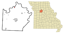 Location of Miami, Missouri | |
| Coordinates: 39°19′21″N 93°13′30″W / 39.32250°N 93.22500°WCoordinates: 39°19′21″N 93°13′30″W / 39.32250°N 93.22500°W | |
| Country | United States |
| State | Missouri |
| County | Saline |
| Area[1] | |
| • Total | 0.63 sq mi (1.63 km2) |
| • Land | 0.56 sq mi (1.45 km2) |
| • Water | 0.07 sq mi (0.18 km2) |
| Elevation | 781 ft (238 m) |
| Population (2010)[2] | |
| • Total | 175 |
| • Estimate (2012[3]) | 176 |
| • Density | 312.5/sq mi (120.7/km2) |
| Time zone | Central (CST) (UTC-6) |
| • Summer (DST) | CDT (UTC-5) |
| ZIP code | 65344 |
| Area code(s) | 660 |
| FIPS code | 29-47684[4] |
| GNIS feature ID | 0722260[5] |
Miami is a city in Saline County, Missouri, United States. The population was 175 at the 2010 census.
History
Miami was platted under the name of Greenville in 1838. It was named Miami in 1843,[6] after the Miami Indians.[7]
Geography
Miami is located at 39°19′21″N 93°13′30″W / 39.322460°N 93.224933°W.[8]
According to the United States Census Bureau, the city has a total area of 0.63 square miles (1.63 km2), of which, 0.56 square miles (1.45 km2) is land and 0.07 square miles (0.18 km2) is water.[1]
Demographics
| Historical population | |||
|---|---|---|---|
| Census | Pop. | %± | |
| 1870 | 742 | — | |
| 1880 | 813 | 9.6% | |
| 1890 | 647 | −20.4% | |
| 1900 | 581 | −10.2% | |
| 1910 | 431 | −25.8% | |
| 1920 | 372 | −13.7% | |
| 1930 | 347 | −6.7% | |
| 1940 | 275 | −20.7% | |
| 1950 | 217 | −21.1% | |
| 1960 | 156 | −28.1% | |
| 1970 | 205 | 31.4% | |
| 1980 | 177 | −13.7% | |
| 1990 | 142 | −19.8% | |
| 2000 | 160 | 12.7% | |
| 2010 | 175 | 9.4% | |
| Est. 2015 | 175 | [9] | 0.0% |
- See also: other Miamis
2010 census
As of the census[2] of 2010, there were 175 people, 60 households, and 46 families residing in the city. The population density was 312.5 inhabitants per square mile (120.7/km2). There were 73 housing units at an average density of 130.4 per square mile (50.3/km2). The racial makeup of the city was 97.7% White, 0.6% African American, 0.6% from other races, and 1.1% from two or more races. Hispanic or Latino of any race were 1.7% of the population.
There were 60 households of which 40.0% had children under the age of 18 living with them, 58.3% were married couples living together, 13.3% had a female householder with no husband present, 5.0% had a male householder with no wife present, and 23.3% were non-families. 16.7% of all households were made up of individuals and 6.6% had someone living alone who was 65 years of age or older. The average household size was 2.92 and the average family size was 3.37.
The median age in the city was 39.3 years. 27.4% of residents were under the age of 18; 8.6% were between the ages of 18 and 24; 20.5% were from 25 to 44; 31.4% were from 45 to 64; and 12% were 65 years of age or older. The gender makeup of the city was 46.9% male and 53.1% female.
2000 census
As of the census[4] of 2000, there were 160 people, 58 households, and 40 families residing in the city. The population density was 285.2 people per square mile (110.3/km²). There were 68 housing units at an average density of 121.2 per square mile (46.9/km²). The racial makeup of the city was 96.88% White, 0.62% African American, 1.88% Native American, 0.62% from other races. Hispanic or Latino of any race were 3.75% of the population.
There were 58 households out of which 34.5% had children under the age of 18 living with them, 50.0% were married couples living together, 13.8% had a female householder with no husband present, and 31.0% were non-families. 24.1% of all households were made up of individuals and 8.6% had someone living alone who was 65 years of age or older. The average household size was 2.76 and the average family size was 3.15.
In the city the population was spread out with 32.5% under the age of 18, 6.9% from 18 to 24, 30.0% from 25 to 44, 22.5% from 45 to 64, and 8.1% who were 65 years of age or older. The median age was 34 years. For every 100 females there were 88.2 males. For every 100 females age 18 and over, there were 89.5 males.
The median income for a household in the city was $27,750, and the median income for a family was $36,042. Males had a median income of $27,000 versus $13,750 for females. The per capita income for the city was $15,055. About 20.5% of families and 26.1% of the population were below the poverty line, including 42.6% of those under the age of eighteen and none of those sixty five or over.
References
- 1 2 "US Gazetteer files 2010". United States Census Bureau. Retrieved 2012-07-08.
- 1 2 "American FactFinder". United States Census Bureau. Retrieved 2012-07-08.
- ↑ "Population Estimates". United States Census Bureau. Retrieved 2013-05-30.
- 1 2 "American FactFinder". United States Census Bureau. Retrieved 2008-01-31.
- ↑ "US Board on Geographic Names". United States Geological Survey. 2007-10-25. Retrieved 2008-01-31.
- ↑ Friends of Miami Museum website
- ↑ Eaton, David Wolfe (1918). How Missouri Counties, Towns and Streams Were Named. The State Historical Society of Missouri. p. 361.
- ↑ "US Gazetteer files: 2010, 2000, and 1990". United States Census Bureau. 2011-02-12. Retrieved 2011-04-23.
- ↑ "Annual Estimates of the Resident Population for Incorporated Places: April 1, 2010 to July 1, 2015". Retrieved July 2, 2016.
- ↑ "Census of Population and Housing". Census.gov. Retrieved June 4, 2015.
External links
- Historic maps of Miami in the Sanborn Maps of Missouri Collection at the University of Missouri
Municipalities and communities of Saline County, Missouri, United States | ||
|---|---|---|
| Cities | 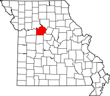 | |
| Villages | ||
| Townships |
| |
| Unincorporated communities | ||
| Footnotes | ‡This populated place also has portions in an adjacent county or counties | |