Metropolitan Borough of Woolwich
| Woolwich | |
|---|---|
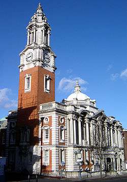 Woolwich Town Hall | |
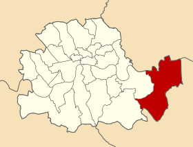 Woolwich within the County of London | |
| History | |
| • Created | 1900 |
| • Abolished | 1965 |
| • Succeeded by |
London Borough of Greenwich London Borough of Newham |
| Status | Metropolitan borough |
| Government |
Woolwich Borough Council |
| • HQ | Wellington Street |
| • Motto |
Clamant nostra tela in Regis querela (Our weapons clash in the King's quarrel) |
 Coat of arms of the borough council | |
The Metropolitan Borough of Woolwich was a metropolitan borough in the County of London from 1900 to 1965. It was formed from the civil parishes of Eltham, Plumstead and Woolwich. Its former area is now part of the Royal Borough of Greenwich and the London Borough of Newham.
Formation and boundaries
The borough was formed from three civil parishes: Eltham, Plumstead and Woolwich. In 1930 these three were combined into a single civil parish called Borough of Woolwich, which was conterminous with the metropolitan borough.[1]
Previous to the borough's formation it had been administered by three separate local bodies: Lee District Board of Works, Plumstead Vestry and Woolwich Local Board of Health.
Population and area
The area of the borough varied between 8,277 and 8,282 acres (33.5 km2). The population, as recorded at the census, was:[2]
Constituent parishes 1801-1899
| Year[2] | 1801 | 1811 | 1821 | 1831 | 1841 | 1851 | 1861 | 1871 | 1881 | 1891 |
|---|---|---|---|---|---|---|---|---|---|---|
| Population | 12,619 | 20,983 | 21,277 | 22,411 | 30,787 | 43,177 | 69,064 | 67,880 | 74,963 | 98,966 |
Metropolitan Borough 1900-1961
| Year | 1901 | 1911 | 1921 | 1931 | 1941 | 1951 | 1961 |
|---|---|---|---|---|---|---|---|
| Population | 117,178 | 121,376 | 140,389 | 146,881 | [3] | 147,891 | 146,603 |
Politics
The borough was divided into eleven wards for elections: Burrage, Central, Dockyard, Eltham, Glyndon, Herbert, River, St George's, St Margaret's, St Mary's and St Nicholas.[4][5]
Parliament constituency
For elections to Parliament, the borough was represented by one constituency:
In 1918 the borough's representation was increased to two seats:
Abolition
Most of it was amalgamated with the Metropolitan Borough of Greenwich to form the London Borough of Greenwich, but small parts north of the river, including North Woolwich, were instead included in the London Borough of Newham.
References
- ↑ GB Historical GIS / University of Portsmouth, Borough of Woolwich CP through time | Census tables with data for the Parish-level Unit, A Vision of Britain through Time. http://www.visionofbritain.org.uk/unit/10235698 Date accessed: 19th February 2015
- 1 2 Statistical Abstract for London, 1901 (Vol. IV).
- ↑ The census was suspended for World War II
- ↑ Post Office London County Suburbs Directory, 1919. 1919. Retrieved 18 February 2015.
- ↑ Ordnance Survey 'County Series 3rd Edition' Map of London (1912-14) at 1:2500 scale. Accessed at https://www.old-maps.co.uk/
Further reading
- Robert Donald, ed. (1907). "London: Woolwich". Municipal Year Book of the United Kingdom for 1907. London: Edward Lloyd.
Local government districts abolished or transferred by the London Government Act 1963 | ||
|---|---|---|
| London | ||
| Essex | ||
| Hertfordshire | ||
| Middlesex, CC | ||
| Kent | ||
| Surrey | ||
| Transfers | Middlesex to Hertfordshire: Potters Bar
| |
Coordinates: 51°29′23″N 0°03′53″E / 51.4896°N 0.0647°E