Messinian salinity crisis
The Messinian Salinity Crisis (MSC), also referred to as the Messinian Event, and in its latest stage as the Lago Mare event, was a geological event during which the Mediterranean Sea went into a cycle of partly or nearly complete desiccation throughout the latter part of the Messinian age of the Miocene epoch, from 5.96 to 5.33 Ma (million years ago). It ended with the Zanclean flood, when the Atlantic reclaimed the basin.[1][2]
Sediment samples from below the deep seafloor of the Mediterranean Sea, which include evaporite minerals, soils, and fossil plants, show that, about 5.96 million years ago in the late Miocene period, the precursor of the Strait of Gibraltar closed tight and the Mediterranean Sea, for the first time and then repeatedly, partially desiccated.[3] The strait closed 5.6 Ma for the last time and, because of the generally dry climate conditions, within a millennium the Mediterranean basin nearly completely dried out, evaporating into a deep dry basin bottoming at some places 3 to 5 km (1.9 to 3.1 mi) below the world ocean level, with a few hypersaline Dead Sea-like pockets. Around 5.5 Ma, less dry climatic conditions allowed the basin to resume receiving more fresh water from rivers, with pockets of Caspian-like brackish waters getting progressively less hyper-saline, until the Strait of Gibraltar finally reopened 5.33 Ma with the Zanclean flood.[4]
Even now the Mediterranean is saltier than the North Atlantic because of its near isolation by the Strait of Gibraltar and its high rate of evaporation. If the Strait of Gibraltar closes again, which is likely to happen in the near geological future (though extremely distantly on a human time scale), the Mediterranean would mostly evaporate in about a thousand years.[5] After that, continued northward movement of Africa may obliterate the Mediterranean: see Mediterranean Ridge.
Naming and first evidence
The Messinian salt deposits that are outcropping (because they were uplifted by tectonic activity during later episodes) in places like Messina in Sicily, northeast Libya, Italy, and southern Spain have been described since the 19th century and it is then that the salinity crisis theory started to be developed.
Karl Mayer-Eymar (1826–1907), a Swiss geologist and palaeontologist, studied fossils between gypsum-bearing, brackish and freshwater sediment layers and identified them as having been deposited just before the end of the Miocene Epoch. In 1867, he named the period the Messinian, for the region of Messina, Italy.[6] Since then, salt-bearing and gypsum-bearing evaporite layers in many Mediterranean countries have been dated to that period.[7]
Confirmation and further evidence
In 1961, seismic surveying of the Mediterranean basin revealed a geological feature some 100–200 m (330–660 ft) below the seafloor. This feature, dubbed the M reflector, closely followed the contours of the present seafloor, suggesting that it was laid down evenly and consistently at some point in the past. The origin of this layer was largely interpreted as related to salt deposition. However, different interpretations were proposed for the age of salt and its deposition.
Earlier suggestions from Denizot in 1957[8] and Ruggieri in 1967[9] proposed that this layer was Late Miocene in age, and the same Ruggieri coined the term Messinian Salinity Crisis.
New and high-quality seismic data on the M-reflector were acquired in the Mediterranean Basin in 1970, published by e.g. Auzende et al. (1971).[10] At the same time, the salt was cored during Leg 13 of the Deep Sea Drilling Program conducted from the Glomar Challenger under the supervision of co-chief scientists William B.F. Ryan and Kenneth J. Hsu. These deposits were dated and interpreted for the first time as deep-basin products of the Messinian Salinity Crisis.


The first drilling of the Messinian salt at the deeper parts of the Mediterranean Sea came in the summer of 1970, when geologists aboard the Glomar Challenger brought up drill cores containing arroyo gravels and red and green floodplain silts; and gypsum, anhydrite, rock salt, and various other evaporite minerals that often form from drying of brine or seawater, including in a few places potash, left where the last bitter, mineral-rich waters dried up. One drill core contained a wind-blown cross-bedded deposit of deep-sea foraminiferal ooze that had dried into dust and been blown about on the hot dry abyssal plain by sandstorms, mixed with quartz sand blown in from nearby continents, and ended up in a brine lake interbedded between two layers of halite. These layers alternated with layers containing marine fossils, indicating a succession of drying and flooding periods.
The massive presence of salt does not require a desiccation of the sea.[11] The main evidence for the evaporative drawdown of the Mediterranean comes from the remains of many (now submerged) canyons that were cut into the sides of the dry Mediterranean basin by rivers flowing down to the abyssal plain.[12][13] For example, the Nile cut its bed down to several hundred feet below sea level at Aswan (where Ivan S. Chumakov found marine Pliocene foraminifers in 1967), and 2,500 m (8,200 ft) below sea level just north of Cairo.[14]
In many places in the Mediterranean, fossilized cracks have been found where muddy sediment had dried and cracked in the sunlight and drought. In the Western Mediterranean series, the presence of pelagic oozes interbedded within the evaporites suggests that the area was repeatedly flooded and desiccated over the course of 700,000 years.[15]
Chronology
Based on palaeomagnetic datings of Messinian deposits that have since been brought above sea level by tectonic activity, the salinity crisis started at the same time over all the Mediterranean basin, at 5.96 ± 0.02 million years ago. This episode comprises the second part of what is called the "Messinian" Epoch. The Epoch was characterised by several stages of tectonic activity and sea level fluctuations, as well as erosional and depositional events, all more or less interrelated (van Dijk et al., 1998).[16]
The Mediterranean-Atlantic strait closed tight time and time again, and the Mediterranean Sea, for the first time and then repeatedly, partially desiccated. The basin was finally isolated from the Atlantic Ocean for a longer period, between 5.59 and 5.33 million years ago, resulting in a large or smaller (depending on the scientific model applied) lowering of the Mediterranean sea level. During the initial, very dry stages (5.6–5.5 Ma), there was extensive erosion, creating several huge canyon systems.[12][13] (some similar in scale to the Grand Canyon) around the Mediterranean. Later stages (5.50–5.33 Ma) are marked by cyclic evaporite deposition into a large "lake-sea" basin ("Lago Mare" event).
About 5.33 million years ago, at the start of the Zanclean age (at the start of the Pliocene epoch), the barrier at the Strait of Gibraltar broke one last time, re-flooding the Mediterranean basin in the Zanclean flood (Blanc, 2002;[17] Castellanos et al., 2009[18]), favouring slope destabilization (Gargani et al., 2014).[19] The basin has not desiccated since.
Several cycles
The amount of Messinian salts has been estimated as around 4·1018 kg (but this estimate may be reduced by 50 to 75% when more information becomes available[20]) and more than 1 million cubic kilometres,[21] exceeding by a factor of 50 the amount of salt normally contained in the Mediterranean waters. This suggests either a succession of desiccations or a long period of hypersalinity during which incoming water from the Atlantic Ocean was evaporated with the level of the Mediterranean brine being similar to that of the Atlantic.[22] The nature of the strata points strongly to several cycles of the Mediterranean Sea completely drying and being refilled (Gargani and Rigollet, 2007[3]), with drying periods correlating to periods of cooler global temperatures; which were therefore drier in the Mediterranean region. Each refilling was presumably caused by a seawater inlet opening, either tectonically, or by a river flowing eastwards below sea level into the "Mediterranean Sink" cutting its valley head back west until it let the sea in, similarly to a river capture. The last refilling was at the Miocene/Pliocene boundary, when the Strait of Gibraltar broke wide open permanently.[18] Upon closely examining the Hole 124 core, Kenneth J. Hsu found that:
The oldest sediment of each cycle was either deposited in a deep sea or in a great brackish lake. The fine sediments deposited on a quiet or deep bottom had perfectly even lamination. As the basin was drying up and the water depth decreased, lamination became more irregular on account of increasing wave agitation. Stromatolite was formed then, when the site of deposition fell within an intertidal zone. The intertidal flat was eventually exposed by the final desiccation, at which time anhydrite was precipitated by saline ground water underlying sabkhas. Suddenly seawater would spill over the Strait of Gibraltar, or there would be an unusual influx of brackish water from the eastern European lake. The Balearic abyssal plain would then again be under water. The chicken-wire anhydrite would thus be abruptly buried under the fine muds brought in by the next deluge.(Hsu, 1983)[23]
Research since then has suggested that the desiccation-flooding cycle may have repeated several times[24][25] during the last 630,000 years of the Miocene epoch. This could explain the large amount of salt deposited. Recent studies, however, show that the repeated desiccation and flooding is unlikely from a geodynamic point of view.[26][27]
Synchronism versus diachronism—deep water versus shallow water evaporites
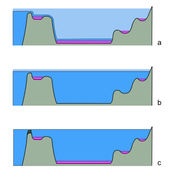
a: Diachronous deposition: Evaporites (pink) were deposited in landward basins first, and closer to the Atlantic as the extent of the Mediterranean Sea (dark blue) diminished towards the gateway. The light blue shows the original sea level.
b: Synchronous deposition in marginal basins. Sea level drops slightly, but the whole basin is still connected to the Atlantic. Reduced inflow allows the accumulation of evaporites in shallow basins only. c: Synchronous, basin-wide deposition. Closure or restriction of the Atlantic seaway by tectonic activity (dark grey) causes evaporite deposition simultaneously across the entire basin; the basin may not need to empty completely, as salts are concentrated by evaporation.
Some major questions remain concerning the beginning of the crisis in the central Mediterranean Basin. The geometric physical link between the evaporitic series identified in marginal basins accessible for field studies, such as the Tabernas basin and Sorbas basin, and the evaporitic series of the central basins has never been made.
Using the concept of deposition in both shallow and deep basins during the Messinian (i.e. assuming that both Basin types existed during this period), two major groupings are evident: one that favours a synchronous deposition (image c) of the first evaporites in all the basins before the major phase of erosion (Krijgsman et al., 1999);[28] and the other that favours a diachronous deposition (image a) of the evaporites through more than one phases of desiccation which would first have affected the marginal basins and later the central basins (Clauzon et al., 1996).[4]
Another school suggests that desiccation was synchronous, but occurred mainly in shallower basins. This model would suggest that the sea level of the whole Mediterranean basin fell at once, but only shallower basins dried out enough to deposit salt beds. See image b.
As highlighted in the work of van Dijk (1992)[29] and van Dijk et al. (1998) [16] the history of desiccation and erosion was complexely interacting with tectonic uplift and subsidence events, and erosional episodes. They also questioned again like some previous authors had done, whether the basins now observed as "deep" were actually also deep during the Messinian Episode and gave different names to the end-member scenarios described above.
Distinguishing between these hypotheses requires the calibration of gypsum deposits. Gypsum is the first salt (calcium sulphate) to be deposited from a desiccating basin. Magnetostratigraphy offers a broad constraint on timing, but no fine detail. Therefore, cyclostratigraphy is relied upon to compare the dates of sediments. The typical case study compares the gypsum evaporites in the main Mediterranean basin with those of the Sorbas basin, a smaller basin on the flanks of the Mediterranean Sea that is now exposed in southern Spain. The relationship between these two basins is assumed to represent the relationships of the wider region.
Recent work has relied on cyclostratigraphy to correlate the underlying marl beds, which appear to have given way to gypsum at exactly the same time in both basins (Krijgsman, 2001) .[30] The proponents of this hypothesis claim that cyclic variations in bed compositions are astronomically tuned, and the beds' magnitude can be calibrated to show they were contemporaneous—a strong argument. In order to refute it, it is necessary to propose an alternative mechanism for generating these cyclic bands, or for erosion to have coincidentally removed just the right amount of sediment everywhere before the gypsum was deposited. The proponents claim that the gypsum was deposited directly above the correlated marl layers, and slumped into them, giving the appearance of an unconformable contact.[30] However, their opponents seize upon this apparent inconformity, and claim that the Sorbas basin was exposed—therefore eroding—while the Mediterranean sea was depositing evaporites. This would result in the Sorbas basin being filled with evaporites at 5.5 million years ago (Ma), compared to the main basin at 5.96 Ma.(Riding, 2000;[31] Braga, 2006[32]).
Recent works have highlighted a pre-evaporite phase corresponding to a prominent erosional crisis (also named "Messinian Erosional crisis"; the termination of the "Mes-1" unconformity bound depositional sequence of van Dijk, 1992)[29] responding to a major drawdown of the Mediterranean seawater (Bache et al., 2009) .[33] Assuming that this major drawdown corresponds to the major Messinian drawdown, they concluded that the Mediterranean bathymetry significantly decreased before the precipitation of central basins evaporites. Regarding these works, a deep water formation seems unlikely. The assumption that central basin evaporites partly deposited under a high bathymetry and before the major phase of erosion should imply the observation of a major detritic event above evaporites in the basin. Such a depositional geometry has not been observed on data. This theory corresponds to one of the end-member scenarios discussed by van Dijk et al. (1998).[16]
Causes
Several possible causes of the series of Messinian crises have been considered. While there is disagreement on all fronts, the most general consensus seems to agree that climate had a role in forcing the periodic filling and emptying of the basins, and that tectonic factors must have played a part in controlling the height of the sills restricting flow between the Atlantic and Mediterranean (Gargani and Rigollet, 2007).[34] The magnitude and extent of these effects, however, is widely open to interpretation (see, e.g., van Dijk et al. (1998).[16]
In any case, the causes of the closing and isolation of the Mediterranean Sea from the Atlantic Ocean must be found in the area where nowadays the Strait of Gibraltar is located. In that area, one of the tectonic boundaries between the African Plate and the European Plate and its southern fragments such as the Iberian Plate, is located. This boundary Zone is characterised by the presence of an arc shaped tectonic feature, the Gibraltar Arc, which includes southern Spain and northern Africa. In the present day area of the Mediterranean Sea, three of these arc shaped belts are present: the Gibraltar Arc, the Calabrian Arc, and the Aegean Arc. The kinematics and dynamics of this plate boundary and of the Gibraltar Arc during the late Miocene are strictly related to the causes of the Messinian Salinity Crisis: Tectonic reconfiguration may have closed and re-opened passages; the region where the connection with the Atlantic Ocean was situated is permeated by strike-slip faults and rotating blocks of continental crust. As faulting accommodated the regional compression caused by Africa's convergence with Eurasia, the geography of the region may have altered enough to open and close seaways. However, the precise tectonic activity behind the motion can be interpreted in a number of ways. An extensive discussion can be found in Weijermars (1988).[35]
Any model must explain a variety of features of the area:
- Shortening and extension occur at the same time in close proximity; sedimentary sequences and their relations to fault activity constrain the rates of uplift and subsidence quite precisely
- Fault-bounded continental blocks can often be observed to rotate
- The depth and structure of the lithosphere is constrained by records of seismic activity, as well as tomography
- The composition of igneous rocks varies—this constrains the location and extent of any subduction.
There are three contending geodynamic models that may fit the data, models which have been discussed in an equal way for the other arc shaped features in the Mediterranean (for a systematic review see van Dijk & Okkes, 1990):[36]
- A moving subduction zone may have caused periodic regional uplift. Changes in volcanic rocks suggest that subduction zones at the rim of the Tethys Sea may have rolled back westwards, changing the chemistry and density in magma underlying the western Mediterranean (Lonergan & White, 1997).[37] However, this does not account for the periodic emptying and refilling of the basin.
- The same features can be explained by regional delamination (Turner, 1999)[38] or the loss of a layer of the entire lithosphere (Seber, 1996).[39]
- Deblobbing, the loss of a "blob" of lithospheric mantle, and the subsequent upward motion of the overlying crust (which has lost its dense mantle "anchor") may also have caused the observed phenomena (Platt & Vissers, 1989)[40] although the validity of the "deblobbing" hypothesis has been called into question (Jackson et al., 2004).[41]
Of these, only the first model, invoking rollback, seems to explain the rotations observed. However, it is difficult to fit it with the pressure and temperature histories of some metamorphic rocks (Platt et al., 1998).[42]
This has led to some interesting combinations of the models which at first hand looked bizarre, in attempts to approach the true state of affairs (e.g. Jolivet et al., 2006;[43] Duggen et al., 2003[44]).
Changes in climate must almost certainly be invoked to explain the periodic nature of the events. They occur during cool periods of Milankovic cycles, when less solar energy reached the Earth. This led to less evaporation of the North Atlantic, hence less rainfall over the Mediterranean. This would have starved the basin of water supply from rivers and allowed its desiccation.
Contrary to many people's instincts, there is now a scientific consensus that global sea level fluctuations cannot have been the major cause, although it may have played a role. The lack of ice caps at the time means there was no realistic mechanism to cause significant changes in sea level—there was nowhere for the water to go, and the morphology of ocean basins cannot change on such a short timescale.
Relationship to climate
The climate of the abyssal plain during the drought is unknown. There is no situation on Earth directly comparable to the dry Mediterranean, and thus it is not possible to know its climate. There is not even a consensus as to whether the Mediterranean Sea even dried out completely; it seems likeliest that at least three or four large brine lakes on the abyssal plains remained at all times. The extent of desiccation is very hard to judge due to the reflective seismic nature of the salt beds, and the difficulty in drilling cores, making it difficult to map their thickness.
Nonetheless, one can study the forces at play in the atmosphere to arrive at a good speculation of the climate. As winds blew across the "Mediterranean Sink", they would heat or cool adiabatically with altitude. In the empty Mediterranean Basin the summertime temperatures would probably have been extremely high even during the coldest phase of any glacial era. Using the dry adiabatic lapse rate of around 10 °C (18 °F) per kilometer, a theoretical temperature of an area 4 kilometres (2.5 mi) below sea level would be about 40 °C (72 °F) warmer than the temperature at sea level. Under this simplistic assumption, theoretical temperature maxima would have been around 80 °C (176 °F) at the lowest depths of the dry abyssal plain permitting little life other than extremophiles. One can also calculate that 2 to 3 miles (3.2 - 4.8 km) below sea level would have resulted in 1.45 to 1.71 atm (1,102 to 1,300 mmHg) of air pressure at the bottom. Although it was probably quite dry in the Basin, there is no direct way to measure how much drier it would have been compared to its surroundings. Areas with less severe depths would probably have been very dry.
Today the evaporation from the Mediterranean Sea supplies moisture that falls in frontal storms, but without such moisture, the Mediterranean climate that we associate with Italy, Greece, and the Levant would be limited to the Iberian Peninsula and the western Maghreb. Climates throughout the central and eastern basin of the Mediterranean and surrounding regions to the north and east would have been drier even above modern sea level. The eastern Alps, the Balkans, and the Hungarian plain would also be much drier than they are today, even if the westerlies prevailed as they do now. However, the Paratethys ocean provided water to the area north of the Mediterranean basin. The Wallachian-Pontic and Hungarian basins were underwater during the Miocene, modifying the climate of what is now the Balkans and other areas north of the Mediterranean basin. The Pannonian Sea was a source of water north of the Mediterranean basin until the middle Pleistocene before becoming the Hungarian plain. Debate exists whether the waters of the Wallachian-Pontic basin (and the possibly connected Pannonian Sea) would have had access (thus bringing water) to at least the eastern Mediterranean basin at times during the Miocene.
Effects
Effects on biology


The Messinian event also provided an opportunity for many African species, including antelopes, elephants and hippopotami, to migrate into the empty basin, close to the descending great rivers, to reach interior wetter cooler highlands such as Malta: as the sea level was dropping, as such species would not have been able to cross the wide hot empty sink at maximum dryness. After the return of the sea water, they remained on the islands, where they underwent insular dwarfism during the Pleistocene as on Crete (Hippopotamus creutzburgi), on Cyprus (H. minor), on Malta (H. melitensis) and Sicily (H. pentlandi). Of these, the Cyprus Dwarf Hippopotamus survived until the end of the Pleistocene or early Holocene.[45][46] But some of these species may have crossed the sea when it was flooded, washed out to sea on rafts of floating vegetation, or with some species (e.g. elephants) by swimming.
Global effects
The water from the Mediterranean would have been redistributed in the world ocean, raising global sea level by as much as 10 m (33 ft). The Mediterranean basin also sequestered below its seabed a significant percentage of the salt from Earth's oceans; this decreased the average salinity of the world ocean and raised its freezing point.[22]
Dehydrated geography

R Rifean corridor
B Betic corridor
G Strait of Gibraltar
M Mediterranean sea
The notion of a completely waterless Mediterranean Sea has some corollaries.
- At the time, the Strait of Gibraltar was not open, but other seaways (the Betic corridor to the north where the Sierra Nevada or Baetic Cordillera is now, or to the south where the Rifean corridor or corridors where the Rif Mountains are now) linked the Mediterranean to the Atlantic. These must have closed, isolating the basin from the open ocean.
- The high level of salinity cannot be tolerated by many known organisms, a factor in reducing the biodiversity of much of the basin.
- The basin's low altitude would have made it extremely hot during the summer through adiabatic heating, a conclusion supported by the presence of anhydrite, which is only deposited in water warmer than 35 °C (95 °F).[47][48]
- Rivers emptying into the basin would have cut their beds much deeper (at least a further 2,400 m (7,900 ft) in the case of the Nile, as the buried canyon under Cairo shows)[49][50] and in the Rhone valley (Gargani, 2004).[51]
Replenishment
When the Strait of Gibraltar was ultimately breached, the Atlantic Ocean would have poured a vast volume of water through what would have presumably been a relatively narrow channel. This refill has been envisaged as resulting in a large waterfall higher than today's Angel Falls at 979 m (3,212 ft), and far more powerful than either the Iguazu Falls or the Niagara Falls, but recent studies of the underground structures at the Gibraltar Strait show that the flooding channel descended in a rather gradual way to the dry Mediterranean.[18]
In popular culture
There had been speculations about a possible dehydration of the Mediterranean Sea in the distant past, even before geology developed.
- In the first century, Pliny the Elder recounted a popular story in his Natural History according to which the Mediterranean Sea was created when the Atlantic ocean gained admission through the Strait of Gibraltar:
At the narrowest part of the Straits, there are mountains placed to form barriers to the entrance on either side, Abyla in Africa, and Calpe in Europe, the boundaries formerly of the Labours of Hercules. Hence it is that the inhabitants have called them the Columns of that god; they also believe that they were dug through by him; upon which the sea, which was before excluded, gained admission, and so changed the face of nature.[52]
- In 1920, H. G. Wells published a popular history book in which it was suggested that the Mediterranean basin had in the past been cut off from the Atlantic. One piece of physical evidence, a deep channel past Gibraltar, had been noticed. Wells estimated that the basin had refilled roughly between 30,000 and 10,000 BC.[53] The theory he printed was that:[53]
 Wells' 1920s speculative map of 50,000 years ago
- In the last Ice Age, so much ocean water was taken into the ice caps that world ocean level dropped below the sill in the Strait of Gibraltar.
- Without the inflow from the Atlantic, the Mediterranean would evaporate much more water than it receives, and would evaporate down to two large lakes, one on the Balearic Abyssal Plain, the other further east.
- The east lake would receive most of the incoming river water, and may have overflowed into the west lake.
- All or some of this seabed may have had a human population, where it was watered from the incoming rivers.
- There is a long deep submerged valley running from the Mediterranean out into the Atlantic.
- (Modern research has shown that Wells' theory is incorrect. All the geological and plant-fossil evidence shows that the Mediterranean did not dry out during the last ice age. Sea levels were 120 m lower than today, resulting in a shallower Strait of Gibraltar and a reduced water exchange with the Atlantic, but there was no cut-off.[54])
- Atlantropa, also referred to as Panropa,[55] was a gigantic engineering and colonization project devised by the German architect Herman Sörgel in the 1920s and promulgated by him until his death in 1952. Its central feature was a hydroelectric dam to be built across the Strait of Gibraltar,[56] and the lowering of the surface of the Mediterranean Sea by up to 200 metres. Similar projects have appeared in fiction.
- Poul Anderson's Time Patrol story "Gibraltar Falls" (1975) takes place while the Atlantic begins to fill the Mediterranean Sea; here "falls" means "waterfall".
- Harry Turtledove's novella "Down in the Bottomlands" takes place on an alternate Earth where the Mediterranean Sea stayed empty, and void of water, and part of it is a national park to the countries around it, none of which are nations that we are familiar with in the real world.
- The episode "The Vanished Sea" of the Animal Planet/ORF/ZDF-produced television series The Future Is Wild posits a world 5 million years in the future where the Mediterranean Basin has again dried up, and explores what kind of life could survive the new climate.
- Julian May's 1980s science fiction books The Many Colored Land and The Golden Torc are set in Europe just before and during the rupture at Gibraltar. The rupture and the rapid filling of the Mediterranean form a Wagnerian climax to The Golden Torc, in which aliens and time-traveling humans are caught up in the cataclysm.
- The Gandalara Cycle by Randall Garrett and Vicki Ann Heydron chronicles the adventures of Ricardo, a modern earth man, sent into the past, where he discovers an entire civilization at the bottom of the dry Mediterranean.
- Wolfgang Jeschke's time-travel novel, The Last Day of Creation, happens 5 million years ago, while the Mediterranean bed was dry.
References
- ↑ Gautier, F., Clauzon, G., Suc, J.P., Cravatte, J., Violanti, D., 1994. Age and duration of the Messinian salinity crisis. C.R. Acad. Sci., Paris (IIA) 318, 1103–1109.
- ↑ Krijgsman, W.; Garcés, M.; Langereis, C.G.; Daams, R.; Van Dam, J.; Van Der Meulen, A.J.; Agustí, J.; Cabrera, L.; Langereis, C. G.; Daams, R.; Van Dam, J.; Van Der Meulen, A. J.; Agustí, J.; Cabrera, L. (1996). "A new chronology for the middle to late Miocene continental record in Spain". Earth and Planetary Science Letters. 142 (3–4): 367–380. Bibcode:1996E&PSL.142..367K. doi:10.1016/0012-821X(96)00109-4. Retrieved 2008-03-01.
- 1 2 Gargani J.; Rigollet C. (2007). "Mediterranean Sea level variations during the Messinian Salinity Crisis.". Geophysical Research Letters. 34: L10405. Bibcode:2007GeoRL..3410405G. doi:10.1029/2007gl029885.
- 1 2 Clauzon, Georges, Suc, Jean-Pierre, Gautier, François, Berger, André, Loutre, Marie-France; Suc; Gautier; Berger; Loutre (1996). "Alternate interpretation of the Messinian salinity crisis: Controversy resolved?" (abstract). Geology. 24 (4): 363–366. Bibcode:1996Geo....24..363C. doi:10.1130/0091-7613(1996)024<0363:AIOTMS>2.3.CO;2.
- ↑ "Only the inflow of Atlantic water maintains the present Mediterranean level. When that was shut off sometime between 6.5 to 6 MYBP, net evaporative loss set in at the rate of around 3,300 cubic kilometers yearly. At that rate, the 3.7 million cubic kilometres of water in the basin would dry up in scarcely more than a thousand years, leaving an extensive layer of salt some tens of meters thick and raising global sea level about 12 meters." Cloud, P. (1988). Oasis in space. Earth history from the beginning, New York: W.W. Norton & Co. Inc., 440. ISBN 0-393-01952-7
- ↑ Mayer-Eymar, Karl (1867) Catalogue systématique et descriptif des fossiles des terrains tertiaires qui se trouvent du Musée fédéral de Zürich (Zürich, Switzerland: Librairie Schabelitz, 1867), page 13. From page 13: "Dans ces circonstances, je crois qu'il m'est permis comme créateur d'une classification conséquente et logique de proposer pour l'étage en question un nom qui lui convient en tous points. Ce nom est celui d'Etage messinien." (In these circumstances, I think that I am permitted as the creator of a consistent and logical classification to propose for the stage in question a name that suits it in every way. That name is that of the Messinian stage.)
- ↑ Kenneth J. Hsu, The Mediterranean Was a Desert, Princeton University Press, Princeton, New Jersey 1983. A Voyage of the Glomar Challenger.
- ↑ Denizot, G. (1952). Le Pliocène dans la vallée du Rhône. Rev. Geogr. Lyon 27. pp. 327–357.
- ↑ Ruggieri, G.; Adams, C.J.; Ager, D.V. (1967). "The Miocene and latter evolution of the Mediterranean Sea". Aspects of Tethyan Biogeography. London, England: Systematic Association Publication. p. 283.
- ↑ Auzende J.M.; Bonnin J.; Olivet J.L.; Pautot G.; Mauffret A. (1971). "Upper Miocene salt layer in the western Mediterranean". Nat. Phys. Sci. 230: 82–84. doi:10.1038/physci230082a0.
- ↑ Garcia-Castellanos Villaseñor (2011). "Messinian salinity crisis regulated by competing tectonics and erosion at the Gibraltar Arc". Nature. 480: 359–363. doi:10.1038/nature10651. PMID 22170684.
- 1 2 Gargani J.; Rigollet C; Scarselli S. (2010). "Isostatic response and geomorphological evolution of the Nile valley during the Messinian salinity crisis.". Bull. Soc. Geol. Fr. 181: 19–26. doi:10.2113/gssgfbull.181.1.19.
- 1 2 Gargani J. (2004). "Modelling of the erosion in the Rhone valley during the Messinian crisis (France)". Quaternary International. 121: 13–22. doi:10.1016/j.quaint.2004.01.020.
- ↑ Warren, J.K. (2006). Evaporites: sediments, resources and hydrocarbons. Birkhäuser. p. 352. ISBN 978-3-540-26011-0. Retrieved 9 June 2010.
- ↑ Wade, B.S.; Brown P.R. (2006). "Calcareous nannofossils in extreme environments: The Messinian Salinity Crisis, Polemi Basin, Cyprus" (PDF). Palaeogeography, Palaeoclimatology, Palaeoecology. 233 (3–4): 271–286. doi:10.1016/j.palaeo.2005.10.007.
- 1 2 3 4 van Dijk, J.P., Barberis, A., Cantarella, G., and Massa, E. (1998); Central Mediterranean Messinian basin evolution. Tectono-eustasy or eustato-tectonics? Annales Tectonicae, 12, n. 1-2, 7-27.
- ↑ Blanc, P.-L. (2002) The opening of the Plio-Quaternary Gibraltar Strait: assessing the size of a cataclysm. Geodin. Acta, 15, 303–317.
- 1 2 3 Garcia-Castellanos D.; Estrada F.; Jiménez-Munt I.; Gorini C.; Fernàndez M.; Vergés J.; De Vicente R. (2009). "Catastrophic flood of the Mediterranean after the Messinian salinity crisis". Nature. 462: 778–781. doi:10.1038/nature08555. PMID 20010684.
- ↑ Gargani J.; F. Bache; G. Jouannic; C. Gorini (2014). "Slope destabilization during the Messinian Salinity Crisis.". Geomorphology. 213: 128–138. doi:10.1016/j.geomorph.2013.12.042.
- ↑ William Ryan (2008). "Modeling the magnitude and timing of evaporative drawdown during the Messinian salinity crisis" (PDF). Sedimentology. 5 (3–4): 229.
- ↑ William Ryan (2008). "Decoding the Mediterranean salinity crisis". Sedimentology. 56 (1): 95–136. Bibcode:2009Sedim..56...95R. doi:10.1111/j.1365-3091.2008.01031.x.
- 1 2 Lecture 17: Mediterranean
- ↑ Hsu, K.J. (1983). "A Voyage of the Glomar Challenger". The Mediterranean Was a Desert. Princeton, New Jersey: Princeton University Press.
- ↑ Gargani J., Rigollet C. (2007). "Mediterranean Sea level variations during the Messinian Salinity Crisis.". Geophysical Research Letters. 34 (L10405): L10405. Bibcode:2007GeoRL..3410405G. doi:10.1029/2007GL029885.
- ↑ Gargani J.; Moretti I.; Letouzey J. (2008). "Evaporite accumulation during the Messinian Salinity Crisis : The Suez Rift Case.". Geophysical Research Letters. 35 (2): L02401. Bibcode:2008GeoRL..35.2401G. doi:10.1029/2007gl032494.
- ↑ Govers, R. (2009). Choking the Mediterranean to dehydration: The Messinian salinity crisis Geology, 37 (2), 167-170 doi:10.1130/G25141A.1 Link
- ↑ Garcia-Castellanos, D., A. Villaseñor, 2011. Messinian salinity crisis regulated by competing tectonics and erosion at the Gibraltar Arc. Nature, 2011-12-15 pdf here Link
- ↑ Krijgsman W.; Hilgen F. J.; Raffi I.; Sierro F. J.; Wilson D. S. (1999). "Chronology, causes and progression of the Messinian salinity crisis". Nature. 400 (6745): 652–655. Bibcode:1999Natur.400..652K. doi:10.1038/23231.
- 1 2 van Dijk, J.P. (1992, d); Late Neogene fore-arc basin evolution in the Calabrian Arc (Central Mediterranean). Tectonic sequence stratigraphy and dynamic geohistory. With special reference to the geology of Central Calabria. Geologica Ultrajectina, 92, 288 pp. ISBN 90-71577-46-5
- 1 2 Krijgsman, W.; Fortuin, A.R.; Hilgen, F.J.; Sierro, F.J. (2001). "Astrochronology for the Messinian Sorbas basin (SE Spain) and orbital (precessional) forcing for evaporite cyclicity". Sedimentary Geology. 140 (1–2): 43–60. Bibcode:2001SedG..140...43K. doi:10.1016/S0037-0738(00)00171-8.
- ↑ Riding, R.; Braga, J.C.; Martín, J.M. (2000). "Late Miocene Mediterranean desiccation: topography and significance of the 'Salinity Crisis' erosion surface on-land in southeast Spain: Reply". Sedimentary Geology. 133 (3–4): 175–184. Bibcode:2000SedG..133..175R. doi:10.1016/S0037-0738(00)00039-7.
- ↑ Braga, J.C.; Martín, J.M.; Riding, R.; Aguirre, J.; Sánchez-almazo, I.M.; Dinarès-turell, J. (2006). "Testing models for the Messinian salinity crisis: The Messinian record in Almería, SE Spain". Sedimentary Geology. 188: 131–154. Bibcode:2006SedG..188..131B. doi:10.1016/j.sedgeo.2006.03.002.
- ↑ Bache, F.; Olivet, J. L.; Gorini, C.; Rabineau, M.; Baztan, J.; Aslanian, D.; Suc, J. P. (2009). "The Messinian Erosional and Salinity Crises: View from the Provence Basin (Gulf of Lions, Western Mediterranean)". Earth Planet. Sci. Lett. 286 (3–4): 139–157. Bibcode:2009E&PSL.286..139B. doi:10.1016/j.epsl.2009.06.021.
- ↑ Gargani J, Rigollet C (2007). "Mediterranean Sea level variations during the Messinian Salinity Crisis.". Geophysical Research Letters. 34 (L10405): L10405. Bibcode:2007GeoRL..3410405G. doi:10.1029/2007GL029885.
- ↑ Weijermars, R. (1988). "Neogene tectonics in the Western Mediterranean may have caused the Messinian Salinity crisis and an associated glacial event". Tectonophysics. 148 (3-4): 211–219. doi:10.1016/0040-1951(88)90129-1. Retrieved May 2015. Check date values in:
|access-date=(help) - ↑ van Dijk, J.P., and Okkes, F.W.M. (1991); Neogene tectonostratigraphy and kinematics of Calabrian Basins. implications for the geodynamics of the Central Mediterranean. Tectonophysics, 196, 23-60.
- ↑ Lonergan, L.; White, N. (1997). "Origin of the Betic-Rif mountain belt". Tectonics. 16 (3): 504–522. Bibcode:1997Tecto..16..504L. doi:10.1029/96TC03937. Retrieved 2008-04-04.
- ↑ Turner, S. (1999). "Magmatism Associated with Orogenic Collapse of the Betic-Alboran Domain, SE Spain" (PDF). Journal of Petrology. 40 (6): 1011–1036. doi:10.1093/petrology/40.6.1011. Retrieved 2008-04-04.
- ↑ Seber, D.; Barazangi, M.; Ibenbrahim, A.; Demnati, A. (1996). "Geophysical evidence for lithospheric delamination beneath the Alboran Sea and Rif--Betic mountains". Nature. 379 (6568): 785–790. Bibcode:1996Natur.379..785S. doi:10.1038/379785a0.
- ↑ Platt, J.P.; Vissers, R.L.M. (1989). "Extensional collapse of thickened continental lithosphere; a working hypothesis for the Alboran Sea and Gibraltar Arc" (abstract). Geology. 17 (6): 540–543. Bibcode:1989Geo....17..540P. doi:10.1130/0091-7613(1989)017<0540:ECOTCL>2.3.CO;2. Retrieved 2008-04-04.
- ↑ Jackson, J.A.; Austrheim, H.; McKenzie, D.; Priestley, K. (2004). "Metastability, mechanical strength, and the support of mountain belts". Geology. 32 (7): 625–628. Bibcode:2004Geo....32..625J. doi:10.1130/G20397.1.
- ↑ Platt, J.P.; Soto, J.I.; Whitehouse, M.J.; Hurford, A.J.; Kelley, S.P. (1998). "Thermal evolution, rate of exhumation, and tectonic significance of metamorphic rocks from the floor of the Alboran extensional basin, western Mediterranean". Tectonics. 17 (5): 671–689. Bibcode:1998Tecto..17..671P. doi:10.1029/98TC02204. Archived from the original (abstract) on 2008-06-11. Retrieved 2008-04-04.
- ↑ Jolivet, L.; Augier, R.; Robin, C.; Suc, J.P.; Rouchy, J.M. (2006). "Lithospheric-scale geodynamic context of the Messinian salinity crisis". Sedimentary Geology. 188: 9–33. Bibcode:2006SedG..188....9J. doi:10.1016/j.sedgeo.2006.02.004.
- ↑ Svend Duggen, Kaj Hoernle, Paul van den Bogaard, Lars Rüpke and Jason Phipps Morgan (2003). "Deep roots of the Messinian salinity crisis". Nature. 422 (6932): 602–6. Bibcode:2003Natur.422..602D. doi:10.1038/nature01553. PMID 12686997.
- ↑ A. Simmons (2000). "Faunal extinction in an island society: pygmy hippopotamus hunters of Cyprus". Geoarchaeology. 15 (4): 379–381. doi:10.1002/(SICI)1520-6548(200004)15:4<379::AID-GEA7>3.0.CO;2-E.
- ↑ Petronio, C. (1995). "Note on the taxonomy of Pleistocene hippopotamuses" (PDF). Ibex. 3: 53–55. Retrieved 2008-08-23.
- ↑ Warren, John K. (2006). Evaporites: sediments, resources and hydrocarbons. Birkhäuser. p. 147. ISBN 978-3-540-26011-0.
- ↑ Majithia, Margaret; Nely, Georges, eds. (1994). Evaporite sequences in petroleum exploration: Geological methods. Editions TECHNIP. ISBN 978-2-7108-0624-0.
- ↑ "Vast "Grand Canyon" Lurks 8,200 Feet BENEATH Cairo, Egypt". Biot Report 403. September 21, 2006.
- ↑ Gargani J.; Rigollet C; Scarselli S. "Isostatic response and geomorphological evolution of the Nile valley during the Messinian salinity crisis.". Bull. Soc. Geol. Fr. 181: 19–26. doi:10.2113/gssgfbull.181.1.19.
- ↑ Gargani J. "Modelling of the erosion in the Rhone valley during the Messinian crisis (France)". Quaternary International. 121: 13–22. doi:10.1016/j.quaint.2004.01.020.
- ↑ Pliny the Elder, Natural History, Book 3, Introduction.
- 1 2 Wells, H. G. (1920). The Outline of History. Garden City, New York: Garden City Publishing Co., Inc. ISBN 1-117-08043-9.
- ↑ Mikolajewicz, U. "Modeling Mediterranean Ocean climate of the Last Glacial Maximum". Retrieved 5 March 2011.
- ↑ Hanns Günther (Walter de Haas) (1931). In hundert Jahren. Kosmos.
- ↑ "Atlantropa: A plan to dam the Mediterranean Sea." 16 March 2005. Archive. Xefer. Retrieved on 4 August 2007.
Further reading
- Kenneth J. Hsu. The Mediterranean Was a Desert: A Voyage of the Glomar Challenger. Princeton University Press. ISBN 0-691-02406-5.
- Roveri; et al. (2008). "A high-resolution stratigraphic framework for the latest Messinian events in the Mediterranean area" (PDF). Stratigraphy. 5 (3–4): 323–342.
External links
-
 Media related to Messinian salinity crisis at Wikimedia Commons
 - Arizona University: Geology 212, Lecture 17: "When the Mediterranean Dried Up". (Accessed 7/16/06)
- The Messinian Salinity Crisis by Ian West (Internet Archive copy)
- A brief history of the Messinian on Sicily by Rob Butler. Archived
- Messinian online