Mersing
| Mersing مرسيڠ 丰盛港 | ||
|---|---|---|
| Town | ||
| ||
 | ||
| Coordinates: 2°26′N 103°50′E / 2.433°N 103.833°ECoordinates: 2°26′N 103°50′E / 2.433°N 103.833°E | ||
| Country |
| |
| State |
| |
| Population (2005)[1] | ||
| • Total | 69,947 | |
| Postcode | 86xxx | |
| Calling code | +6-07 | |
| Vehicle registration | J | |
| Website | mdmersing.gov.my | |

Mersing (Chinese: 丰盛港) is a town and the capital of Mersing District, Johor, Malaysia.
Mersing town (estimated population in 2009: 21,670)[2] is a town visited by Malaysians and foreign tourists on the way to the Tioman Islands.
Mersing town is particularly significant for a number of reasons: it is one of only two major towns situated in the eastern half of Johor state (the other being Kota Tinggi), it lies on the main trunk road that connects southern as well as eastern Johor with the east coast of Pahang state including Pahang's capital Kuantan (part of Federal Route ![]() ), and it is the main departure point for ferries to the nearby offshore islands such as Tioman Island.
), and it is the main departure point for ferries to the nearby offshore islands such as Tioman Island.

Geographic Location
Mersing port in the mouth of Mersing River is also the main port for ferries to Tioman Island and the more than 40 other islands in the Seribuat Archipelago.
Although Tioman Island is geographically closer to Johor, it is administratively part of the state of Pahang. This makes Mersing town analogous to Kuala Perlis as the port of departure for an island that is located in another state (Kuala Perlis, which is in Perlis, is the port of departure for Langkawi Island, which, though geographically closer to Perlis, is part of the state of Kedah).
Climate
| Climate data for Mersing | |||||||||||||
|---|---|---|---|---|---|---|---|---|---|---|---|---|---|
| Month | Jan | Feb | Mar | Apr | May | Jun | Jul | Aug | Sep | Oct | Nov | Dec | Year |
| Average high °C (°F) | 28.1 (82.6) |
29.0 (84.2) |
30.3 (86.5) |
31.6 (88.9) |
32.0 (89.6) |
31.4 (88.5) |
30.9 (87.6) |
30.9 (87.6) |
30.9 (87.6) |
31.0 (87.8) |
29.7 (85.5) |
28.2 (82.8) |
30.3 (86.5) |
| Daily mean °C (°F) | 25.6 (78.1) |
26.2 (79.2) |
26.6 (79.9) |
26.7 (80.1) |
26.7 (80.1) |
26.3 (79.3) |
25.8 (78.4) |
25.8 (78.4) |
25.7 (78.3) |
25.8 (78.4) |
25.6 (78.1) |
25.5 (77.9) |
26.0 (78.8) |
| Average low °C (°F) | 23.4 (74.1) |
23.6 (74.5) |
23.2 (73.8) |
22.9 (73.2) |
23.0 (73.4) |
21.8 (71.2) |
22.3 (72.1) |
22.3 (72.1) |
22.2 (72) |
22.4 (72.3) |
22.6 (72.7) |
23.0 (73.4) |
22.7 (72.9) |
| Average precipitation mm (inches) | 291.3 (11.469) |
125.6 (4.945) |
131.5 (5.177) |
124.1 (4.886) |
145.2 (5.717) |
141.0 (5.551) |
159.2 (6.268) |
174.4 (6.866) |
179.0 (7.047) |
204.4 (8.047) |
375.6 (14.787) |
662.4 (26.079) |
2,713.7 (106.839) |
| Average precipitation days (≥ 1.0 mm) | 12 | 8 | 8 | 10 | 11 | 11 | 13 | 13 | 13 | 14 | 19 | 20 | 152 |
| Mean monthly sunshine hours | 169.6 | 200.4 | 229.8 | 211.5 | 222.8 | 200.6 | 199.1 | 193.7 | 175.7 | 175.8 | 142.5 | 129.0 | 2,250.5 |
| Source: NOAA[3] | |||||||||||||
Transportation
Car
Being located along Highway ![]() , Mersing is relatively accessible for a town its size. Northward this highway goes to Kuantan, Kuala Terengganu and Kota Bharu before terminating at Rantau Panjang at the border with Thailand. Southwards highway 3 terminates at Johor Bahru, the state capital.
, Mersing is relatively accessible for a town its size. Northward this highway goes to Kuantan, Kuala Terengganu and Kota Bharu before terminating at Rantau Panjang at the border with Thailand. Southwards highway 3 terminates at Johor Bahru, the state capital.
Entertainment
Although a small town, Mersing is very well serviced by a wide range of restaurants, cafes and traditional coffee shops. There are also close to modern or western supermarkets and traditional shops providing many services including internet services and western meals for foreign tourists. The main District Hospital is also located in Mersing town and there are also many private medical clinics if medical services are required. Most Malaysian banks also have branches in Mersing town. Near to the ferry jetty in Mersing town is a public park with playground facilities for children and restaurants.
To explore Mersing truly, it is recommended that tourists walk. There is relatively light traffic in the area and a bicycle would be an excellent mode of travel as well.
Attractions
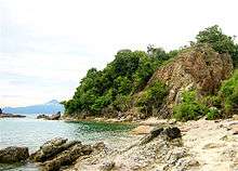
From Mersing, tourists can visit many nearby beaches. Beaches in the Mersing area rival beaches on the islands nearby. These are easily accessible from Mersing town. Other interesting places to visit near to Mersing town are Endau town, a major off-shore fishing port in Johor (about 33 km (21 mi) from Mersing town) and Penyabong, a very quiet fishing village located in a beautiful cove by the sea (about 20 km (12 mi) from Mersing town). Another attraction is the Endau Rompin National Park in the north.
There are numerous hotels at reasonable prices catering to the many Malaysian and foreign tourists who visit the Mersing town throughout the year.
The Chinese community in Mersing mainly belongs to the Cantonese dialect group and speak Cantonese, however, many locals, especially business owners have no issue conversing in Mandarin.
Administration
Mersing is administered by Majlis Daerah Mersing or the Mersing District Council. Mersing's postcode is 86800.
References
- ↑ Proposed Mersing Laguna Reclamation - Detailed Environmental Impact Assessment, by DHI Water & Environment Sdn. (M) Bhd., http://www.doe.gov.my/dmdocuments/EIA/Mersing%20Laguna%20DEIA%20Executive%20Summary.pdf
- ↑ Helders, Stefan. "Malaysia: largest cities and towns and statistics of their population". World Gazetteer. Retrieved 2009-03-23.
- ↑ "Mersing Climate Normals 1961–1990". National Oceanic and Atmospheric Administration. Retrieved 24 March 2015.
External links
 Mersing travel guide from Wikivoyage
- Mersing In facebook
| ECER Kelantan | |
|---|---|
| ECER Terengganu |
|
| ECER Pahang |
|
| ECER Johor | |