Merseyway Shopping Centre
 New logo introduced in 2010 | |
| Location | Stockport |
|---|---|
| Coordinates | 53°24′40″N 2°09′33″W / 53.41111°N 2.15917°W |
| Address |
The Management Suite, 52-54 Great Underbank, Stockport, SK1 1PD |
| Opening date | 1965 |
| Developer | Hammerson |
| Management | GVA Grimley |
| Owner | In Receivership with GVA Grimley |
| No. of stores and services | 95 |
| No. of anchor tenants | 3 |
| Total retail floor area | 32,050 metres2 (344,983 sq ft) |
| No. of floors | 2 |
| Parking | 835 Spaces |
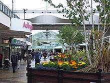
Merseyway Shopping Centre is a large shopping centre in Stockport, England. Adjoining onto Mersey Square, it forms the basis of the town's main shopping area. Opened in 1965 and extensively refurbished in the 1990s, it consists mainly of a large pedestrianised area built on stilts over the River Mersey. There are two levels of walkways giving access to the retail units. Merseyway is mostly an open air precinct, though the front area (at the western end) was given a canopy in the 1990s and is now enclosed forming a small mall.
The developer was Hammerson who also owned the centre until 2003 when they sold the leasehold to a private property company (Stockport Holdings Ltd) owned by the Jersey-based Halabi family trust.[1] In 2009, the centre was placed into receivership.
The anchor stores are Debenhams and Marks & Spencer and there are approximately 85 other retailers..[2][3] To the south and east of the centre are the Peel Centre and the towns' historic Market.[4]
The centre and Stockport's shopping area attract about 14 million visitors per year, making it a prominent shopping destination in the Greater Manchester Urban Area. Its catchment covers much of the affluent areas of North Cheshire and South Manchester, competing with other major retail destinations in the area such as Manchester City Centre, Ashton-under-Lyne and the Trafford Centre.[5] The centre also hosts numerous promotional events at Christmas and throughout the year.[6]
Location
The centre's name, Merseyway, comes from the fact that the centre is built on giant stilts above the River Mersey and the river runs for the entire length of the centre.[7] In 2001 there were plans to fit glass panels to the pavements within the centre to reveal the River Mersey underneath, this was a plan to try to boost tourism in the town as the river is entirely covered and hidden while it runs under the centre. However there has been no development of these plans. In 2015 a section of pavement at the junction of Tiviot Dale and Warren Street was opened up allowing pedestrians a view of the river running under a reconstructed archway.[7]
History

The centre was opened in 1965, as one of the first shopping precincts in the United Kingdom, since then it has undergone considerable development.
In the 1990s, Merseyway was extensively refurbished including the creation a new area of covered mall at the western edge of the centre facing onto Mersey Square.
In Administration

In February 2009, the centre was placed into the hands of receivers, the directors of GVA Grimley, due to the owners (Stockport Holdings Ltd), placing the centre into Administration. This statement appeared on the centre's website on 16 February 2009;[8]
"On 16th February 2009 Directors of GVA Grimley were appointed Receivers under the Law of Property Act overMerseyway Shopping Centre, Stockport. The Centre will continue to be managed by DTZ."[8]
— Unknown Author, Merseyway Shopping Centre Website
The Directors of GVA Grimley have stressed that the centre will continue to trade as normal and all retailers have been notified of the status, they have also said that in the current economic situation they will not seek to sell the centre, they will continue to run the centre and build upon its potential alongside the local authority and under current management DTZ.[8]
Retailers
There are around 100 tenants altogether in the centre, consisting of around five large department-type stores, which act as the principal anchors, alongside many more national chain stores. Stores include BHS, Marks & Spencer, Primark, Boots, W.H. Smith, River Island, HMV, Deichmann, McDonald's and Argos.[9] Debenhams also have a department store in adjacent Princes Street. Independent traders locate themselves in the adjacent streets, such as Princes Street, the Underbanks and the Market Place.[10]
To the immediate east of the centre are two of the town's main supermarkets, Sainsbury's and Asda. A large Tesco Extra store is located within walking distance on the opposite side of the M60 motorway. Retail developments competing for similar tenants have sprung up around the centre, these include The Peel Centre, The Courts Shopping Centre and the planned Bridgefield development. Additionally some of the more traditional shopping streets such as Hillgate play host to independent retailers due to lower rents, as well as a small collection of national chain stores.
Transport links
The centre is easily accessible by car, from junctions 26, 27 or 1 of the M60 motorway, via the A6 from Manchester or Buxton.[11] There is extensive parking at the centre with a multi-storey carpark spread over a large area, containing 835 spaces and 31 disabled spaces. Additionally there is much more parking surrounding the centre.[12] The town's bus station is located directly opposite the western edge of the centre,[13] and close to the bus station, up the hill is Stockport railway station, which is accessible via the A6 or via a walkway from the bus station to the railway station.[14]
Future development
The adjacent area to the north of the centre (between Princes Street and the M60 motorway) is currently being developed into another shopping and leisure complex called Bridgefield, due to open in 2017. It is planned to contain more sizeable retail units to try to attract some of the larger stores into Stockport compared to the on-average smaller units currently offered in the town centre by Merseyway. In addition to shops, the new complex will also contain a cinema. Once completed, it is expected that this development will directly compete with Merseyway for similar tenants.
External links
- Merseway Shopping Centre Official Website
- visitmanchester.com - Official Tourism site for Greater Manchester
- Stockport Metropolitan Borough Council
- DTZ UK (Managers of the Centre)
References
- ↑ "Grand Central sells for £11m". Manchester Evening News. M.E.N. Media. 17 May 2004. Retrieved 1 April 2008.
- ↑ "Merseyway Shopping Centre - Retailers". Merseyway Shopping Centre. Archived from the original on 14 July 2008. Retrieved 9 March 2008. External link in
|publisher=(help) - ↑ "Westgate Department Store - Stockport". Anglia Regional Co-operative Society. Retrieved 9 March 2008.
- ↑ "Stockport MBC - Stockport Market". Stockport Metropolitan Borough Council. Archived from the original on 8 March 2010. Retrieved 5 April 2010.
- ↑ "Merseyway Shopping Centre - Profile" (PDF). Merseyway Shopping Centre. Archived from the original (PDF) on 29 October 2008. Retrieved 7 March 2008. External link in
|publisher=(help) - ↑ Rathbone, Gemma (19 December 2007). "Reindeers 'sleigh' the winter crowds". Stockport Express. M.E.N. Media. Retrieved 1 April 2008.
- 1 2 "Mersey view plan for shoppers". Manchester Evening News. M.E.N. Media. 7 December 2001. Retrieved 1 April 2008.
- 1 2 3 James Chapelard (31 March 2009). "Stockport's Merseyway centre in administration - Crain's Manchester Business". Crain's Manchester Business. Retrieved 9 May 2009.
- ↑ "Merseyway Shopping Centre - Retailers". Merseyway Shopping Centre. Archived from the original on 14 July 2008. Retrieved 9 March 2008. External link in
|publisher=(help) - ↑ "Stockport MBC - Stockport Market". Stockport Metropolitan Borough Council. Retrieved 5 April 2010.
- ↑ "Merseyway Shopping Centre - Google Maps". Google Maps. Retrieved 3 April 2008.
- ↑ "Stockport Metropolitan Borough Council - Town Centre Car Parks". Stockport Metropolitan Borough Council. Archived from the original on 21 November 2009. Retrieved 5 April 2010.
- ↑ "GMPTE - Buses - Bus Station Departures - Stockport (See Bottom of Map)" (PDF). GMPTE. Archived from the original (PDF) on 10 October 2007. Retrieved 3 April 2008.
- ↑ Philips Street Atlas - Greater Manchester (Map) (Pocket Edition - Third Edition First Impression 2004 ed.). Philips Maps. § P170 E8.
Coordinates: 53°24′40″N 2°09′33″W / 53.41111°N 2.15917°W