Merenberg
| Merenberg | ||
|---|---|---|
| ||
 Merenberg | ||
Location of Merenberg within Limburg-Weilburg district 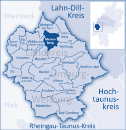 | ||
| Coordinates: 50°31′N 8°11′E / 50.517°N 8.183°ECoordinates: 50°31′N 8°11′E / 50.517°N 8.183°E | ||
| Country | Germany | |
| State | Hesse | |
| Admin. region | Gießen | |
| District | Limburg-Weilburg | |
| Government | ||
| • Mayor | Reiner Kuhl | |
| Area | ||
| • Total | 23.1 km2 (8.9 sq mi) | |
| Population (2015-12-31)[1] | ||
| • Total | 3,189 | |
| • Density | 140/km2 (360/sq mi) | |
| Time zone | CET/CEST (UTC+1/+2) | |
| Postal codes | 35799 | |
| Dialling codes | 06471 | |
| Vehicle registration | LM | |
| Website | www.merenberg.de | |

Merenberg is a community in Limburg-Weilburg district in Hesse, Germany.
Geography
Location
Merenberg lies on the southern edge of the Westerwald between the district seat of Limburg and Weilburg.
Neighbouring communities
Merenberg borders in the north on the community of Mengerskirchen, in the east on the community of Löhnberg, in the south on the town of Weilburg, in the southwest on the community of Beselich, and in the west on the community of Waldbrunn (all in Limburg-Weilburg).
Constituent communities
The market community of Merenberg consists of the five centres of Merenberg, Barig-Selbenhausen, Allendorf, Reichenborn and Rückershausen.
History
On both the Almerskopf and the Höhburg are found remnants of settlements from La Tène times.
In Merenberg stands the family castle of the House of Merenberg, a noble family in the 12th and 13th centuries. In connection with this family, the community had its first documentary mention in 1129. In 1290, Merenberg was granted town rights and weekly market rights by King Rudolph I, whereupon a town wall was built. In 1634 the castle was destroyed, and since then it has stood, as a ruin, as Merenberg’s landmark.
In the early 19th century, Merenberg was stripped of town rights. In the late 19th century, the House of Nassau named the children from Prince Nikolaus Wilhelm of Nassau's marriage to a Russian noblewoman the “Counts of Merenberg”.
In the course of administrative reform in Hesse, the formerly autonomous communities of Allendorf, Barig-Selbenhausen, Merenberg, Reichenborn and Rückershausen, which had all belonged to the old Oberlahnkreis (district), merged into the new collective community of Merenberg.
Allendorf had its first documentary mention in 1250, Rückershausen in 1370 and Reichenborn in 1435.
Politics
Community council
The municipal election held on 26 March 2006 yielded the following results:
| Parties and voter communities | % 2006 |
seats 2006 |
% 2001 |
seats 2001 | |
| CDU | Christian Democratic Union of Germany | 39.7 | 9 | 36.0 | 8 |
| SPD | Social Democratic Party of Germany | 39.7 | 9 | 43.3 | 10 |
| GRÜNE | Bündnis 90/Die Grünen | 6.0 | 2 | 3.3 | 1 |
| BM/FWG | Bürgerliste/Freie Wählergemeinschaft Merenberg | 14.6 | 3 | 17.3 | 4 |
| Total | 100.0 | 23 | 100.0 | 23 | |
| voter turnout in % | 54.7 | 57.3 | |||
Coat of arms
The community’s arms are those formerly borne by the Lords of Merenberg, which were also represented in the old Oberlahnkreis district’s (seat: Weilburg) arms.
Sightseeing
 Merenberg castle ruins
 Historic town gate in Merenberg
 Historic Evangelical church in Merenberg
 Historic Appenkirche at the current graveyard
 Barig-Selbenhausen

Economy and infrastructure
Besides the trade and crafts that are customary for such a place, there are a few small and medium-size industrial businesses. The main fields of activity are mechanical engineering, plant engineering, metalworking, plastics processing and automation. Merenberg’s best known business is the record label ZYX Music.
Transport
The community lies on Bundesstraße 49, which is currently (February 2006) being widened to four lanes between Limburg and Wetzlar, and which links Merenberg to the long-distance road network.
Education
Merenberg has, with its Albert-Wagner-Schule, a primary school and a Hauptschule. In 1958, it was dedicated as the first Mittelpunktschule (“midpoint school”, a central school, designed to eliminate smaller outlying schools) in Hesse. It was named after the administrative official and politician Albert Wagner. Merenberg lies in the feeder area of the Westerwaldschule, a Hauptschule-Realschule in Mengerskirchen-Waldernbach. Moreover, students from Merenberg attend other secondary schools in Weilburg.
Public institutions
- Kindertagesstätte "Villa Kunterbunt" Merenberg (daycare)
- Kindergarten "Tigerente" Barig-Selbenhausen
- Merenberg Volunteer Fire Brigade, founded 1902 (includes Youth Fire Brigade)
- Allendorf Volunteer Fire Brigade, founded 1926 (includes Youth Fire Brigade)
- Barig-Selbenhausen Volunteer Fire Brigade, founded 1925 (includes Youth Fire Brigade)
- Reichenborn Volunteer Fire Brigade, founded 1925 (includes Youth Fire Brigade)
- Rückershausen Volunteer Fire Brigade, founded 1934 (includes Youth Fire Brigade)
References
- ↑ "Bevölkerung der hessischen Gemeinden". Hessisches Statistisches Landesamt (in German). August 2016.
External links
| Wikimedia Commons has media related to Merenberg. |
Towns and municipalities in Limburg-Weilburg | ||
|---|---|---|