Melrose, Minnesota
| Melrose, Minnesota | |
|---|---|
| City | |
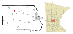 Location of Melrose within Stearns County, Minnesota | |
| Coordinates: 45°40′28″N 94°48′50″W / 45.67444°N 94.81389°W | |
| Country | United States |
| State | Minnesota |
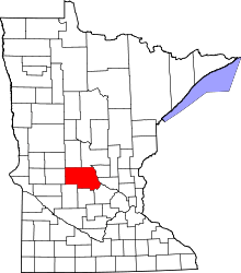
| County | Stearns |
| Government | |
| • Mayor | Joe Finken |
| Area[1] | |
| • Total | 3.32 sq mi (8.60 km2) |
| • Land | 3.19 sq mi (8.26 km2) |
| • Water | 0.13 sq mi (0.34 km2) |
| Elevation | 1,204 ft (367 m) |
| Population (2010)[2] | |
| • Total | 3,598 |
| • Estimate (2012[3]) | 3,601 |
| • Density | 1,127.9/sq mi (435.5/km2) |
| Time zone | Central (CST) (UTC-6) |
| • Summer (DST) | CDT (UTC-5) |
| ZIP code | 56352 |
| Area code(s) | 320 |
| FIPS code | 27-41570[4] |
| GNIS feature ID | 0647757[5] |
| Website | www.cityofmelrose.com |
Melrose is a city in Stearns County, Minnesota, United States. The population was 3,598 at the 2010 census.[6] It is part of the St. Cloud Metropolitan Statistical Area.
Geography
According to the United States Census Bureau, the city has a total area of 3.32 square miles (8.60 km2); 3.19 square miles (8.26 km2) is land and 0.13 square miles (0.34 km2) is water.[1]
Melrose is located along Interstate 94. Other main routes include Stearns County Road 13 and Main Street.
Demographics
| Historical population | |||
|---|---|---|---|
| Census | Pop. | %± | |
| 1890 | 780 | — | |
| 1900 | 1,768 | 126.7% | |
| 1910 | 2,591 | 46.5% | |
| 1920 | 2,529 | −2.4% | |
| 1930 | 1,801 | −28.8% | |
| 1940 | 2,015 | 11.9% | |
| 1950 | 2,106 | 4.5% | |
| 1960 | 2,135 | 1.4% | |
| 1970 | 2,273 | 6.5% | |
| 1980 | 2,409 | 6.0% | |
| 1990 | 2,561 | 6.3% | |
| 2000 | 3,091 | 20.7% | |
| 2010 | 3,598 | 16.4% | |
| Est. 2015 | 3,616 | [7] | 0.5% |
| U.S. Decennial Census | |||
2010 census
As of the census[2] of 2010, there were 3,598 people, 1,309 households, and 890 families residing in the city. The population density was 1,127.9 inhabitants per square mile (435.5/km2). There were 1,410 housing units at an average density of 442.0 per square mile (170.7/km2). The racial makeup of the city was 86.1% White, 0.9% African American, 0.2% Native American, 0.6% Asian, 10.7% from other races, and 1.4% from two or more races. Hispanic or Latino of any race were 22.1% of the population.
There were 1,309 households of which 34.8% had children under the age of 18 living with them, 55.2% were married couples living together, 7.6% had a female householder with no husband present, 5.2% had a male householder with no wife present, and 32.0% were non-families. 28.1% of all households were made up of individuals and 15.9% had someone living alone who was 65 years of age or older. The average household size was 2.69 and the average family size was 3.31.
The median age in the city was 36.5 years. 28.1% of residents were under the age of 18; 8.2% were between the ages of 18 and 24; 24.6% were from 25 to 44; 20.4% were from 45 to 64; and 18.9% were 65 years of age or older. The gender makeup of the city was 49.6% male and 50.4% female.
2000 census
As of the census[4] of 2000, there were 3,091 people, 1,157 households, and 797 families residing in the city. The population density was 1,091.8 people per square mile (421.7/km²). There were 1,206 housing units at an average density of 426.0 per square mile (164.5/km²). The racial makeup of the city was 95.76% White, 0.49% African American, 0.06% Native American, 0.55% Asian, 2.52% from other races, and 0.61% from two or more races. Hispanic or Latino of any race were 12.33% of the population.
There were 1,157 households out of which 35.7% had children under the age of 18 living with them, 57.4% were married couples living together, 7.9% had a female householder with no husband present, and 31.1% were non-families. 27.9% of all households were made up of individuals and 17.4% had someone living alone who was 65 years of age or older. The average household size was 2.61 and the average family size was 3.16. In the city the population was spread out with 27.7% under the age of 18, 8.1% from 18 to 24, 26.7% from 25 to 44, 17.4% from 45 to 64, and 20.1% who were 65 years of age or older. The median age was 36 years. For every 100 females there were 94.5 males. For every 100 females age 18 and over, there were 93.8 males.
The median income for a household in the city was $34,432, and the median income for a family was $45,045. Males had a median income of $30,290 versus $20,389 for females. The per capita income for the city was $15,510. About 4.5% of families and 7.6% of the population were below the poverty line, including 7.8% of those under age 18 and 7.8% of those age 65 or over.
Notable people
- Walter Breuning - He was the oldest man in the world before he died April 14, 2011; born in Melrose in 1896.
- Blake Elliott - Winner of the 2003 Gagliardi Trophy for academic and football excellence.
- Paul Ellering - Retired professional American wrestling manager.
- Matt Herkenhoff - Former professional football player.
- Charles Lindbergh - First person to fly across the Atlantic Ocean without stopping. Lived in Melrose, MN; and some of his childhood toys are in the Melrose Museum; and his grandparents are buried in a cemetery in Melrose.
- Mark Olberding - Former professional basketball player.
- Mitch Clem - Cartoonist, Creator of Nothing Nice to Say.
- Calista Flockhart - Golden Globe winner for Best Actress in a TV Series and star of Ally McBeal; lived in Melrose during part of her childhood
- Amanda Smock - competed in the 2012 Summer Olympics as an American Triple Jumper; she grew up in Melrose. Multiple time winner of USA indoor and outdoor triple jump championships.
- James Gallagher - First man to pilot a flight non-stop around the world in 1949. Grew up in Melrose, MN, 1939 graduate of Melrose High School.
References
- 1 2 "US Gazetteer files 2010". United States Census Bureau. Retrieved 2012-11-13.
- 1 2 "American FactFinder". United States Census Bureau. Retrieved 2012-11-13.
- ↑ "Population Estimates". United States Census Bureau. Retrieved 2013-05-28.
- 1 2 "American FactFinder". United States Census Bureau. Retrieved 2008-01-31.
- ↑ "US Board on Geographic Names". United States Geological Survey. 2007-10-25. Retrieved 2008-01-31.
- ↑ "2010 Census Redistricting Data (Public Law 94-171) Summary File". American FactFinder. U.S. Census Bureau, 2010 Census. Retrieved 23 April 2011.
- ↑ "Annual Estimates of the Resident Population for Incorporated Places: April 1, 2010 to July 1, 2015". Retrieved July 2, 2016.
External links
- Melrose, MN – Official Website
- Melrose Area Chamber of Commerce
- Melrose Area Schools site
- Melrose Beacon newspaper site
Municipalities and communities of Stearns County, Minnesota, United States | ||
|---|---|---|
| Cities |
|  |
| Townships |
| |
| CDP | ||
| Unincorporated communities | ||
| Footnotes | ‡This populated place also has portions in an adjacent county or counties | |
| Core City |  | ||||||
|---|---|---|---|---|---|---|---|
| Surrounding communities |
| ||||||
| Counties | |||||||
‡ indicates that it is partially in the metropolitan area. § indicates a CDP | |||||||
Coordinates: 45°40′29″N 94°48′27″W / 45.67472°N 94.80750°W