McGrath Army Airbase
| McGrath Army Airbase | |||||||||||||||
|---|---|---|---|---|---|---|---|---|---|---|---|---|---|---|---|
 | |||||||||||||||
| IATA: none – ICAO: none | |||||||||||||||
| Summary | |||||||||||||||
| Airport type | Military | ||||||||||||||
| Owner | United States Army | ||||||||||||||
| Serves | McGrath, Alaska | ||||||||||||||
| Elevation AMSL | 341 ft / 104 m | ||||||||||||||
| Coordinates | 62°57′10″N 155°36′25″W / 62.95278°N 155.60694°WCoordinates: 62°57′10″N 155°36′25″W / 62.95278°N 155.60694°W | ||||||||||||||
| Map | |||||||||||||||
 McGrath AAB Location of airport in Alaska | |||||||||||||||
| Runways | |||||||||||||||
| |||||||||||||||
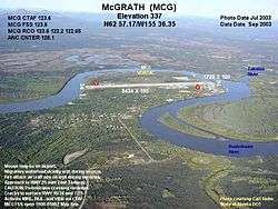
McGrath Army Airbase is former United States Army airbase located in McGrath,[1] a city in the Yukon-Koyukuk Census Area of the U.S. state of Alaska.
During its construction, equipment to construct the facility arrived too late in the season, as the ground had already frozen over. As a result, it was ordered that the equipment be brought to Umnak Island and Cold Bay, Alaska, which built Fort Glenn Army Airbase and Fort Randall Army Airfield, respectively. Both of those airfields later played a part in repelling the Japanese Attack on Dutch Harbor.[2]
See also
- Alaska World War II Army Airfields
- Air Transport Command
- Northwest Staging Route
- List of airports in Alaska
References
- ↑ FAA Airport Master Record for MCG (Form 5010 PDF). Federal Aviation Administration. Effective November 15, 2012.
- ↑ "HISTORY OF THE ELEVENTH AIR FORCE". Eleventh Air Force. Retrieved 15 September 2015.
-
 This article incorporates public domain material from the Air Force Historical Research Agency website http://www.afhra.af.mil/.
Previously: Alaskan Air Force (1941-1942) | |||||||||||||
| Bases |
| .svg.png) | |||||||||||
| Units |
| ||||||||||||
This article is issued from Wikipedia - version of the 12/5/2016. The text is available under the Creative Commons Attribution/Share Alike but additional terms may apply for the media files.