McFarland, Wisconsin
| McFarland, Wisconsin | |
|---|---|
| Village | |
|
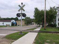
Downtown McFarland with its old railroad. | |
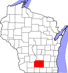
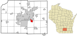 Location in Dane County and the state of Wisconsin. | |
| Coordinates: 43°1′7″N 89°17′28″W / 43.01861°N 89.29111°WCoordinates: 43°1′7″N 89°17′28″W / 43.01861°N 89.29111°W | |
| Country | United States |
| State | Wisconsin |
| County | Dane |
| Area[1] | |
| • Total | 3.55 sq mi (9.19 km2) |
| • Land | 3.55 sq mi (9.19 km2) |
| • Water | 0 sq mi (0 km2) |
| Elevation[2] | 869 ft (265 m) |
| Population (2010)[3] | |
| • Total | 7,808 |
| • Estimate (2012[4]) | 8,040 |
| • Density | 2,199.4/sq mi (849.2/km2) |
| Time zone | Central (CST) (UTC-6) |
| • Summer (DST) | CDT (UTC-5) |
| Area code(s) | 608 |
| FIPS code | 55-46850[5] |
| GNIS feature ID | 1569214[2] |
| Website |
mcfarland |
McFarland is a village in Dane County, Wisconsin, United States, on the eastern shore of Lake Waubesa. The population was 7,808 at the 2010 census.[5] Its ZIP code is 53558. McFarland is part of the Madison Metropolitan Statistical Area.
History
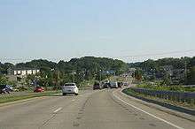
McFarland was founded in 1856 by William H. McFarland. Early industries in the village included harvesting winter ice and fish on nearby Lake Waubesa for rail shipment to markets in Chicago. Later, a small resort industry developed in an area called Edwards Park near the lake. After World War II, the village became a bedroom community for Madison. In the 1960s, Lloyd Schneider, a local lawyer, led an effort to have petroleum tank farms north of the village that were connected to the Koch pipeline. Because they became part of the village's tax base, their construction enabled the McFarland School District to fund a new high school. In 1989 a major highway project on the nearby Madison highway called the Beltline made commuting to the village much easier and enabled rapid residential growth.
On June 17, 1992, an F3 tornado destroyed several dozen homes and injured several people in Waubesa Heights, a nearby housing development in the Town of Dunn, in the McFarland School District. At $18.0 million in damage this was the third-costliest tornado in Wisconsin's history behind the Oakfield and Barneveld F5s.
The village celebrated its sesquicentennial in 2006. Among the festivities were banners on light poles, activities such as the Taste of McFarland, and live music at the Gazebo near downtown McFarland. Plaques of "Then and Now" covering McFarland's 150 years of history were placed at the McFarland High School, the local Culver's restaurant, the E.D. Locke Public Library, and other public locations.
Geography
McFarland is located at 43°1′7″N 89°17′28″W / 43.01861°N 89.29111°W (43.018480, -89.291116).[6]
According to the United States Census Bureau, the village has a total area of 3.55 square miles (9.19 km2), all of its land.[1]
Demographics
| Historical population | |||
|---|---|---|---|
| Census | Pop. | %± | |
| 1880 | 168 | — | |
| 1890 | 166 | −1.2% | |
| 1930 | 313 | — | |
| 1940 | 463 | 47.9% | |
| 1950 | 593 | 28.1% | |
| 1960 | 1,272 | 114.5% | |
| 1970 | 2,386 | 87.6% | |
| 1980 | 3,783 | 58.5% | |
| 1990 | 5,232 | 38.3% | |
| 2000 | 6,416 | 22.6% | |
| 2010 | 7,808 | 21.7% | |
| Est. 2015 | 8,209 | [7] | 5.1% |
2010 census
As of the census[3] of 2010, there were 7,808 people, 3,079 households, and 2,201 families residing in the village. The population density was 2,199.4 inhabitants per square mile (849.2/km2). There were 3,200 housing units at an average density of 901.4 per square mile (348.0/km2). The racial makeup of the village was 94.4% White, 1.2% African American, 0.4% Native American, 1.7% Asian, 0.1% Pacific Islander, 0.7% from other races, and 1.5% from two or more races. Hispanic or Latino of any race were 2.3% of the population.
There were 3,079 households of which 38.8% had children under the age of 18 living with them, 56.9% were married couples living together, 10.1% had a female householder with no husband present, 4.4% had a male householder with no wife present, and 28.5% were non-families. Of all households, 21.9% were made up of individuals and 7.8% had someone living alone who was 65 years of age or older. The average household size was 2.54 and the average family size was 2.96.
The median age in the village was 39.7 years. 26.9% of residents were under the age of 18; 5.6% were between the ages of 18 and 24; 26% were from 25 to 44; 31.2% were from 45 to 64; and 10.3% were 65 years of age or older. The gender makeup of the village was 49.0% male and 51.0% female.
Education
The McFarland School District serves the village of McFarland.[9] It operates Conrad Elvehjem Early Learning Center (K), McFarland Primary School (grades 1–2), Waubesa Intermediate School (3–5), Indian Mound Middle School (6–8) and McFarland High School, which is accredited by the North Central Association of Colleges and Schools and had a 2007 enrollment of 700 students.[10]
Events
Since 1985 McFarland has held an annual fall Family Festival. The festival has carnival rides, train rides, a parade, and many competitions. The three-day festival takes place at McFarland High School parking lot.
Notable people
- Conrad Elvehjem, biochemist
- Realf Ottesen Brandt, Lutheran minister
- Al Epperly, MLB player
- Brad Fischer, adviser for the Pittsburgh Pirates
- Doris Hanson, Wisconsin politician[11]
- Robert L. Hunt, wildlife biologist and expert on trout
- Steve Lacy, 1980 and 1984 Olympic runner, University of Wisconsin Hall of Fame[12]
- Helmar Lewis, Wisconsin State Senator[13]
- Theodore G. Lewis, jurist[14]
- Jana Schneider, actress and journalist
- Barbara Thompson, Wisconsin Superintendent of Public Instruction[15]
References
- 1 2 "US Gazetteer files 2010". United States Census Bureau. Archived from the original on January 24, 2012. Retrieved 2012-11-18.
- 1 2 "US Board on Geographic Names". United States Geological Survey. 2007-10-25. Retrieved 2008-01-31.
- 1 2 "American FactFinder". United States Census Bureau. Retrieved 2012-11-18.
- ↑ "Population Estimates". United States Census Bureau. Archived from the original on June 17, 2013. Retrieved 2013-06-24.
- 1 2 "American FactFinder". United States Census Bureau. Archived from the original on September 11, 2013. Retrieved 2008-01-31.
- ↑ "US Gazetteer files: 2010, 2000, and 1990". United States Census Bureau. 2011-02-12. Retrieved 2011-04-23.
- ↑ "Annual Estimates of the Resident Population for Incorporated Places: April 1, 2010 to July 1, 2015". Retrieved July 2, 2016.
- ↑ "Census of Population and Housing". Census.gov. Archived from the original on May 11, 2015. Retrieved June 4, 2015.
- ↑ McFarland School District
- ↑ "McFarland High School". Retrieved 2009-05-02.
- ↑ Wisconsin Blue Book 1997-1998, Biographical Sketch of Doris Hanson, pg 53
- ↑ UW-Hall of Fame - Steve Lacy
- ↑ Wisconsin Blue Book 1942, Biographical Sketch of Helmar Lewis, pg. 30
- ↑ Wisconsin Supreme Court-Theodore Lewis
- ↑ Wisconsin Blue Book 1975, Biographical Sketch of Barbara Thompson, pg. 6
External links
- Official website
- McFarland School District
- McFarland Chamber of Commerce
- McFarland Historical Society
- Sanborn fire insurance map: 1894
| Surrounding communities |
|  | ||||||
|---|---|---|---|---|---|---|---|---|
| Counties | ||||||||