McDade, Texas
| McDade, Texas | |
|---|---|
| Census-designated place | |
 McDade Location within the state of Texas | |
| Coordinates: 30°17′2″N 97°14′16″W / 30.28389°N 97.23778°WCoordinates: 30°17′2″N 97°14′16″W / 30.28389°N 97.23778°W | |
| Country | United States |
| State | Texas |
| County | Bastrop |
| Area | |
| • Total | 9.3 sq mi (24.2 km2) |
| • Land | 9.3 sq mi (24.0 km2) |
| • Water | 0.08 sq mi (0.2 km2) |
| Elevation | 560 ft (170 m) |
| Population (2010) | |
| • Total | 685 |
| • Density | 258/sq mi (99.7/km2) |
| Time zone | Central (CST) (UTC-6) |
| • Summer (DST) | CDT (UTC-5) |
| ZIP code | 78650 |
| FIPS code | 48-45564[1] |
| GNIS feature ID | 1341178[2] |
McDade is an unincorporated community and census-designated place in northern Bastrop County, Texas, located along U.S. Route 290. As of the 2010 census it had a population of 685.[3] It is 9 miles (14 km) east of Elgin and 34 miles (55 km) east of Austin. It is 21 miles (34 km) west of Giddings.
The community is named for James W. McDade, a major stockholder in the Houston and Texas Central Railroad in 1869.
The McDade Independent School District serves area students.
McDade was, for several years, the childhood home of 1950s television and recording star Gale Storm, as her mother owned a millinery shop in McDade.
References
- ↑ "American FactFinder". United States Census Bureau. Archived from the original on September 11, 2013. Retrieved 2008-01-31.
- ↑ "US Board on Geographic Names". United States Geological Survey. 2007-10-25. Retrieved 2008-01-31.
- ↑ "Geographic Identifiers: 2010 Demographic Profile Data (G001): McDade CDP, Texas". U.S. Census Bureau, American Factfinder. Retrieved April 9, 2014.
External links
Municipalities and communities of Bastrop County, Texas, United States | ||
|---|---|---|
| Cities | 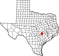 | |
| CDPs | ||
| Other unincorporated communities |
| |
| Ghost towns |
| |
| Footnotes | ‡This populated place also has portions in an adjacent county or counties | |
This article is issued from Wikipedia - version of the 12/4/2016. The text is available under the Creative Commons Attribution/Share Alike but additional terms may apply for the media files.