McCloud River
| McCloud River | |
| McLeod's Fork, McLoud River[1] | |
| River | |
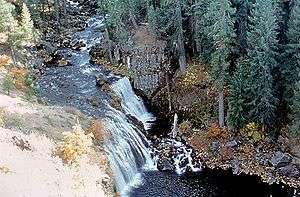 Middle McCloud Falls on the McCloud River | |
| Country | United States |
|---|---|
| State | California |
| City | McCloud |
| Source | |
| - location | Southeast of Mount Shasta, Siskiyou County, California |
| - elevation | 4,677 ft (1,426 m) [2] |
| - coordinates | 41°13′12″N 121°46′21″W / 41.22000°N 121.77250°W [3] |
| Mouth | |
| - location | McCloud River Arm of Lake Shasta, Sacramento River, Shasta County, California |
| - elevation | 1,066 ft (325 m) [3] |
| - coordinates | 40°46′13″N 122°18′13″W / 40.77028°N 122.30361°WCoordinates: 40°46′13″N 122°18′13″W / 40.77028°N 122.30361°W [3] |
| Length | 77 mi (124 km) [4] |
| Basin | 673 sq mi (1,743 km2) |
| Discharge | |
| - average | 1,790 cu ft/s (51 m3/s) |
| - max | 55,000 cu ft/s (1,557 m3/s) |
The McCloud River is a river that flows east of and parallel to the Sacramento River, 77.1 miles (124.1 km) long,[4] in northern California in the United States. It drains a scenic mountainous area of the Cascade Range, especially Mt. Shasta. The river is north of Redding and is a tributary of the Sacramento River.
History
The river was originally known as the "McLeod River", after the Hudson's Bay Company hunter and trapper Alexander Roderick McLeod who explored it during the winter of 1829-1830.[5] By the 1860s, the spelling "McCloud" was widely used, likely because that was the conventional American spelling of the Scottish name, and perhaps in part to honor California pioneer Ross McCloud, who settled here in 1855.[1]
Course
It rises from several spring-fed streams in the Cascades approximately 10 miles (16 km) southeast of Mount Shasta in Siskiyou County. It flows initially west, passing south of Mt. Shasta and receiving streams that drain the southern slope of the peak. From Mt. Shasta it flows generally southwest through Lake McCloud and through the Shasta-Trinity National Forest. It joins Shasta Lake, formed by the Shasta Dam, approximately 15 miles (24 km) north of Redding, with the lower 10 miles (16 km) of the river forming the middle arm of the lake. The McCloud arm joins in at the Pit River Bridge on Interstate 5, 5 miles (8.0 km) north of the city of Shasta Lake.
The river is well known for a series of waterfalls which tumble over basaltic lava flows, known collectively as the Falls of the McCloud River.
Recreation
The McCloud is generally divided into two sections. The Upper McCloud is considered to be above McCloud Reservoir, and the Lower McCloud stretches from the reservoir to Lake Shasta. The waterfalls mentioned above are all found on the Upper McCloud. The Upper McCloud is a popular destination for kayakers. There is an improved campground called Fowlers on the Upper McCloud. The Upper McCloud above Upper Falls is rarely stocked, and locating the fish often proves to be a challenge to most avid anglers, while the section from Lower Falls to Upper Falls is stocked and is open to bait fishing. The Lower McCloud is generally a fly/artificial lure fishery and catch and release fishing is greatly encouraged.
The last several miles of the McCloud comprise two private fishing clubs — the McCloud River Club (4 miles (6.4 km)) and the Bollibokka Club (10 miles (16 km)), founded in 1902 and 1904, respectively. The land encompassing the lower 7 miles (11 km) of Bollibokka Club was purchased in 2007 by the Westlands Water District, which continues to operate the historic Bollibokka Club. Westlands purchased the property to avoid risk of development of the property, to increase its entitlement to water releases from Shasta reservoir through ownership of 3,000 acres (12 km2) in the watershed, and to quell opposition to plans for increases in the height of Shasta Dam, a project in which it is the largest stakeholder.[6] The upper 3 miles (4.8 km) of the club's river holdings were purchased in 2006 by Silicon Valley real estate magnate John Arrillaga. Anglers are not allowed to set foot above the high water mark on either property. The Nature Conservancy has a site on the Lower McCloud, an outright gift from the neighboring McCloud River Club, that allows ten rods per day and unlimited hikers or birders.
There are two campgrounds on the Lower McCloud River — Ash Camp and Ah Di Nah Campground. Ash Camp is a small unimproved camp area about 1 mile (1.6 km) downstream of the McCloud Reservoir dam with 4 sites and a vault toilet. It sits at the junction of Hawkins Creek and the Lower McCloud.
While Ah Di Nah Campground is located only 3 miles (4.8 km) further downstream from Ash Camp, it is about 7 miles (11 km) of dirt road driving to get there. It is a Shasta-Trinity National Forest campground and a fee is charged for nightly camping. Ah Di Nah is popular with backpackers and anglers for its proximity to the Pacific Crest Trail and the Nature Conservancy area on the McCloud River. Bathrooms and water are available.
The McCloud once hosted a native population of Bull trout (Salvelinus confluentus), but the species became extinct in the McCloud watershed after McCloud Reservoir cut off the fish from their spawning grounds. The last reported Bull trout (misidentified as Dolly Varden trout (Salvelinus malma) at that time, Dollys are not from this southern latitude[7]) was caught in the 1980s. The Upper McCloud and its tributaries above Middle Falls are home to the McCloud River redband (Oncorhynchus mykiss stonei), a native subspecies of Rainbow trout.[8]
Gallery
|


References
- 1 2 Erwin G. Gudde, William Bright (2004). California Place Names: The Origin and Etymology of Current Geographical Names. University of California Press. p. 221. Retrieved 2012-02-04.
- ↑ Google Earth elevation for GNIS source coordinates. Retrieved on 2008-01-10.
- 1 2 3 "McCloud River". Geographic Names Information System. United States Geological Survey.
- 1 2 U.S. Geological Survey. National Hydrography Dataset high-resolution flowline data. The National Map Archived 2012-04-05 at WebCite, accessed March 10, 2011
- ↑ David L. Durham (1998). California's Geographic Names: A Gazetteer of Historic and Modern Names of the State. Quill Driver Books. p. 275. ISBN 1-884995-14-4.
- ↑ Greg Lucas, Tom Stienstra (2007-01-28). "Land sale leads to worries over dam". San Francisco Chronicle. Retrieved 2012-02-04.
- ↑ Haas, Gordon R.; McPhail, J. D. (1991). "Systematics and Distributions of Dolly Varden (Salvelinus malma) and Bull Trout (Salvelinus confluentus) in North America". Canadian Journal of Fisheries and Aquatic Sciences. Ottawa: NRC Research Press. 48 (11): 2191–2211. doi:10.1139/f91-259.
- ↑ "Redband Trout (native)". Department of Fish and Wildlife: Resource Management. California Department of Fish and Wildlife. Retrieved 20 August 2013.
External links
| Mountains | 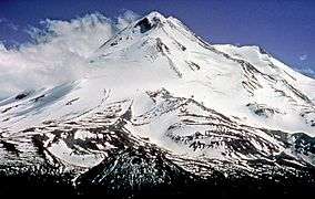 | |
|---|---|---|
| Bodies of Water | ||
| Rivers | ||
| Incorporated Cities | ||
| Counties | ||
| Parks |
| |