Mayran
| Mayran | |
|---|---|
|
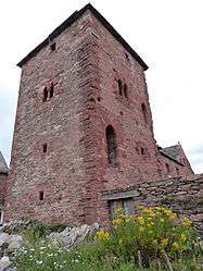
Monastic tower | |
 Mayran | |
|
Location within Occitanie region  Mayran | |
| Coordinates: 44°23′21″N 2°21′51″E / 44.3892°N 2.3642°ECoordinates: 44°23′21″N 2°21′51″E / 44.3892°N 2.3642°E | |
| Country | France |
| Region | Occitanie |
| Department | Aveyron |
| Arrondissement | Rodez |
| Canton | Rignac |
| Intercommunality | Pays Rignacois |
| Government | |
| • Mayor (2008–2014) | Yves Mazars |
| Area1 | 15.36 km2 (5.93 sq mi) |
| Population (2008)2 | 521 |
| • Density | 34/km2 (88/sq mi) |
| Time zone | CET (UTC+1) |
| • Summer (DST) | CEST (UTC+2) |
| INSEE/Postal code | 12142 / 12390 |
| Elevation |
400–734 m (1,312–2,408 ft) (avg. 730 m or 2,400 ft) |
|
1 French Land Register data, which excludes lakes, ponds, glaciers > 1 km² (0.386 sq mi or 247 acres) and river estuaries. 2 Population without double counting: residents of multiple communes (e.g., students and military personnel) only counted once. | |
Mayran is a commune in the Aveyron department in southern France.
Population
| Historical population | ||
|---|---|---|
| Year | Pop. | ±% |
| 1962 | 537 | — |
| 1968 | 565 | +5.2% |
| 1975 | 520 | −8.0% |
| 1982 | 492 | −5.4% |
| 1990 | 472 | −4.1% |
| 1999 | 454 | −3.8% |
| 2008 | 521 | +14.8% |
See also
References
| Wikimedia Commons has media related to Mayran. |
This article is issued from Wikipedia - version of the 7/20/2016. The text is available under the Creative Commons Attribution/Share Alike but additional terms may apply for the media files.