Maya Biosphere Reserve
| Maya Biosphere Reserve | |
| Reserva de biósfera Maya | |
| VI | |
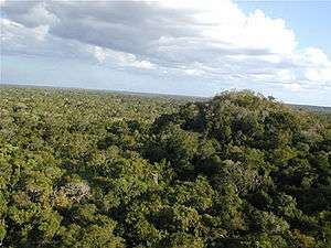 Dense Tropical Rain Forest in El Mirador, Guatemala | |
| Nickname: Mayan Reserve | |
| Country | Guatemala |
|---|---|
| Region | El Petén |
| Highest point | |
| - elevation | 636 m (2,087 ft) |
| Lowest point | |
| - elevation | 50 m (164 ft) |
| Area | 21,602.04 km2 (8,341 sq mi) |
| Biome | Tropical humid forests, including wetlands[1] |
| IUCN category | IX |
The Maya Biosphere Reserve (Reserva de la Biosfera Maya) is a nature reserve in Guatemala managed by Guatemala's National Council of Protected Areas (CONAP). The Maya Biosphere Reserve covers a total area of 21,602 km²,[2] which is considerably larger than Yellowstone National Park.
The park is home to a large number of species of fauna including the jaguar, the puma, the ocelot, the margay, spider monkeys, howler monkeys, tapirs, crocodiles, the red brocket and the white-tail deers, the harpy eagle, several hawk species, the scarlet macaw, fresh water turtles, etc. It is also rich in flora including mahogany, Ceiba, cedar, etc. The area ranges from wetlands, to low mountain ranges, and has several bodies of water, including lakes, rivers, streams and cenotes.
The Reserve was created in 1990 to protect the largest area of tropical forest remaining in Central America. The biosphere reserve model, implemented by UNESCO, seeks to promote a balance between human activities and the biosphere by including sustainable economic development in conservation planning.[3]
Humans activity
The Maya Biosphere Reserve is divided into several zones, each with a different protected status. The core zones are formed by several national parks and biotopes (wildlife preserves), in which no human settlement, logging, or extraction of resources are allowed. These include Laguna del Tigre National Park, Sierra del Lacandón National Park, Mirador-Río Azul National Park, Tikal National Park, El Zotz Biotope, Naachtún-Dos Lagunas Biotope, Cerro Cahuí Biotope, Laguna del Tigre Biotope, and El Pilar Natural Monument.[1][4][5] The core zones cover an area of 7670 km², which is 36% of the Maya Biosphere Reserve.[5]
In multiple-use zones (8484.40 km²; 40%) and the buffer zone (4975 km²; 24%), which comprises the southern portion of the Reserve, certain regulated economic activities are allowed. These include the sustainable harvesting of wood and traditional forest products which include chicle, a sap used in the manufacture of chewing gum, xate, an ornamental palm plant used in floral arrangements, and pimenta or allspice. The Guatemalan government has granted forest concessions to local communities, giving them the right to practice sustainable forestry in delineated areas for 25 years. International monitoring groups such as the Forest Stewardship Council certify logging activities as sustainable. In 2005, 1.1 million acres (4500 km²) were certified.[6] In other parts of the multiple-use zone, farming communities have been granted the right to continue farming in so-called agricultural polygons.[7]
On July 16, 2008, Guatemalan president Alvaro Colom announced the Cuatro Balam plan to develop mass ecotourism around archaeological sites in the Maya Biosphere Reserve. Plan objectives include the development of tourist infrastructure, the installation of a small tourist train from the town of Carmelita to El Mirador, and the creation of a new university for the study of regional biodiversity, genetics, and Maya studies.
Archaeology
The Maya Biosphere Reserve is home to a large concentration of ancient Maya cities, many of which are under excavation. Tikal is the most famous of these, attracting about 120,000[8] to 180,000[1] visitors per year. Tens of other sites exist in varying states of excavation.
The Mirador Basin, in the northern part of the Reserve, contains numerous interconnected Maya cities. The area was named by Dr. Richard Hansen, Director of the Mirador Basin Project and archaeologist at El Mirador, the largest of the sites, dating from the preclassic Maya period. Other cities in the region include El Tintal, Nakbe, and Wakna.
Environmental threats
Ecosystems in Maya Biosphere Reserve face numerous threats from human activities, including illegal logging, farming, and ranching in protected areas, as well as drug trafficking, poaching and looting of Maya artefacts. The forest area of the Reserve has shrunk by 13 percent over the last 21 years according to the non-profit organization Rainforest Alliance, which has several community development projects in the region. Since 2000, illegal cattle ranches have cleared about 8 percent of the reserve.[9] Some of the most extreme deforestation has occurred in the Laguna del Tigre and Sierra del Lancandon National Parks.[10] Resources are scarce for the protection of the Reserve by guards and park rangers, and the area is often considered a lawless wilderness.
Several local organizations, including ProPetén and ACOFOP have made significant contributions to local management of natural and cultural resources.
Notes
- 1 2 3 UNESCO. "MAB Biospheres Reserves Directory: Guatemala – Maya".
- ↑ CONAP. "Listado de Áreas Protegidas (enero, 2011)" (xls) (in Spanish). conap.gob.gt. Retrieved 2011-06-14.
- ↑ "Biosphere Reserves". UNESCO.
- ↑ "Estado Actual de la Reserva Biosfera Maya en Enero 2000". ProPeten.
- 1 2 Ferretti, J. (2007). "Project Executive Summary Request for Council Work Program Inclusion under the GEF Trust Fund" (PDF). gefweb.org. Archived from the original (pdf) on January 14, 2009. Retrieved 2009-06-16.
- ↑ Danna Harman. "At a store near you: eco-friendly lumber". The Christian Science Monitor.
- ↑ McNab, Roan Balas; Ramos, Victor Hugo (April 2007). "The Maya Biosphere Reserve and Human Displacement: Social Patterns and Management Paradigms Under Pressure". In Redford, Kent H. and Eva Fearn. Protected areas and human displacement: A conservation perspective (pdf). Working Paper No. 29. New York: Wildlife Conservation Society. ISSN 1534-7389.
- ↑ "Tourism as an Ally in the fight to save Peten". Inter-American Development Bank.
- ↑ Elbein, Saul From Cocaine Cowboys to Narco-Ranchers Foreign Policy. July 13, 2016
- ↑ Michael Stoll. "A Visit to Beef National Park". Pulitzer Center on Crisis Reporting.
References
- CONAP
- Parks Watch Web Site
- Maya Biosphere Reserve, Guatemala from The Nature Conservancy's website.
- Future of Peten
- Untold Stories, Pulitzer Center on Crisis Reporting
- ProPeten
Coordinates: 17°25′48″N 90°53′26″W / 17.43000°N 90.89056°W