Mawson Peak
| Mawson Peak | |
|---|---|
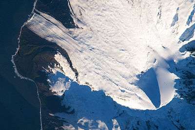 Satellite image of the southern tip of Heard Island. Cape Arkona is seen on the left side of the image, with Lied Glacier just above and Gotley Glacier just below. Big Ben Volcano and Mawson Peak are seen at the lower right side of the image. | |
| Highest point | |
| Elevation | 2,745 m (9,006 ft) [1] |
| Prominence | 2,745 m (9,006 ft) |
| Isolation | 1,922 kilometres (1,194 mi) |
| Listing |
Country high point Ultra |
| Coordinates | 53°6′00″S 73°31′00″E / 53.10000°S 73.51667°ECoordinates: 53°6′00″S 73°31′00″E / 53.10000°S 73.51667°E |
| Geography | |
 Mawson Peak Location of Heard Island | |
| Location | Heard Island, Australia |
| Parent range | Big Ben |
| Topo map | RAN Heard Island 291 |
| Geology | |
| Mountain type | Complex volcano |
| Last eruption | 2012 to 2014 (ongoing) |
Mawson Peak is an active volcanic mountain on Heard Island, an external Australian territory in the Southern Ocean.
With its summit at 2,745 metres (9,006 ft), it is the third highest peak in any state or territory of Australia,[2] higher than the 2,228-metre (7,310 ft) Mount Kosciuszko, and surpassed only by the 3,490-metre (11,450 ft) Mount McClintock and the 3,355-metre (11,007 ft) Mount Menzies in the Australian Antarctic Territory.[3] An active complex volcano which erupted as recently as April 2013 and February 2016,[4] Mawson Peak is the summit of the Big Ben massif.
Discovery and naming
Mawson Peak was named by the 1948 ANARE Heard Island Expedition after the Australian geologist and explorer Sir Douglas Mawson, the leader of BANZARE 1929-31, who visited the island in November – December 1929.[5]
On the 20th February 1950, whilst aboard HMAS Lebuan, Thomas Gratton (Tim) Young OAM observed and recorded in the ship's log that Mawson Peak was an active volcano.
The 1964-65 expedition to Heard Island was led by Major Warwick Deacock, with the schooner Patanela skippered by Major Bill Tilman. They succeeded in climbing Mawson Peak for the first time, which is the highest point on this remote island.
See also
References
- ↑ http://earthobservatory.nasa.gov/IOTD/view.php?id=37488&src=iotdrss
- ↑ "Highest mountains on external territories". Australian Government - Geoscience Australia. Retrieved 2016-05-23.
- ↑ U.S. Geological Survey Geographic Names Information System: Mawson Peak
- ↑ "Scientists witness 'amazing' eruption of volcano on sub-Antarctic island". ABC News. Retrieved 2016-02-01.
- ↑ "Mawson Peak". Antarctic Gazetteer Name Details. Australian Antarctic Division. Retrieved 2010-04-05.
- LeMasurier, WE; Thomson, JW, eds. (1990). Volcanoes of the Antarctic Plate and Southern Oceans. American Geophysical Union. ISBN 0-87590-172-7.
- Title = Aurora Vol 30, No 3 March 2011
External links
- Click here to see a map of Heard Island and McDonald Islands, including all major topographical features
- http://aadc-maps.aad.gov.au/aadc/gaz/display_name.cfm?gaz_id=2026
- http://www.volcano.si.edu/world/volcano.cfm?vnum=0304-01=
- http://www.timbowden.com.au/wp-content/uploads/2012/02/bigben.pdf