Maurice, Louisiana
| Maurice | |
|---|---|
| Village | |
| Village of Maurice | |
| Coordinates: 30°06′26″N 92°07′26″W / 30.10722°N 92.12389°WCoordinates: 30°06′26″N 92°07′26″W / 30.10722°N 92.12389°W | |
| Country |
|
| States |
|
| Population (2013) | |
| • Total | 1,171 |
| Time zone | CST (UTC-6) |
| • Summer (DST) | CDT (UTC-5) |
| Area code(s) | 337 |
Maurice is a village in Vermilion Parish, Louisiana, United States. The population was 642 at the 2000 census. It is part of the Abbeville Micropolitan Statistical Area.
History
The village, originally called "Mauriceville", derives its name from its founder Maurice Villien. Maurice Villien, a native of Savoy, France, who came to America in 1855 and sold goods in New Orleans, New Iberia and Milton. His wife had land holdings there and they established a home and grocery store.[1] On May 29, 1889, the 10-acre (40,000 m2) site, on which the church and rectory in Maurice were to be built, was donated by Villien.[2] The town was incorporated on December 27, 1911 and Joseph Villen, Maurice's son, became mayor until 1928.[3] Today, Joseph Street leads to the old home.
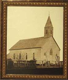
The community's first church was La Chapelle a Maurice and Sunday services were held in a small schoolhouse on the Villien property until the St. Alphonsus Church was built in January 1893. The Broussard Cove School was the first school built on land donated by Joseph Clark in 1885 and moved to Maurice in July 1899 to land donated by Maurice Villien. It was located on Maurice Avenue and the Indian Bayou Road until 1914 when it burned down.[1]
Geography
Maurice is located at 30°6′26″N 92°7′26″W / 30.10722°N 92.12389°W (30.107171, -92.123977).[4]
According to the United States Census Bureau, the village has a total area of 2.0 square miles (5.3 km²), all land.
Demographics
| Historical population | |||
|---|---|---|---|
| Census | Pop. | %± | |
| 1930 | 330 | — | |
| 1940 | 420 | 27.3% | |
| 1950 | 335 | −20.2% | |
| 1960 | 411 | 22.7% | |
| 1970 | 476 | 15.8% | |
| 1980 | 478 | 0.4% | |
| 1990 | 432 | −9.6% | |
| 2000 | 642 | 48.6% | |
| 2010 | 964 | 50.2% | |
| Est. 2015 | 1,266 | [5] | 31.3% |
As of the census[7] of 2000, there were 642 people, 257 households, and 177 families residing in the village. The population density was 315.0 inhabitants per square mile (121.5/km²). There were 276 housing units at an average density of 135.4 per square mile (52.2/km²). The racial makeup of the village was 79.13% White, 19.63% African American, 0.16% Native American, 0.78% Asian, and 0.31% from two or more races. Hispanic or Latino of any race were 1.40% of the population. In 2005, 74.8% of the population over the age of five spoke English at home, and 25.2% of the population spoke French or Cajun.[8]
There were 257 households out of which 37.0% had children under the age of 18 living with them, 52.9% were married couples living together, 12.5% had a female householder with no husband present, and 31.1% were non-families. 27.6% of all households were made up of individuals and 8.9% had someone living alone who was 65 years of age or older. The average household size was 2.49 and the average family size was 3.07.
In the village the population was spread out with 28.2% under the age of 18, 6.9% from 18 to 24, 33.2% from 25 to 44, 19.3% from 45 to 64, and 12.5% who were 65 years of age or older. The median age was 33 years. For every 100 females there were 102.5 males. For every 100 females age 18 and over, there were 88.9 males.
The median income for a household in the village was $29,306, and the median income for a family was $32,841. Males had a median income of $28,571 versus $21,250 for females. The per capita income for the village was $15,051. About 16.6% of families and 19.3% of the population were below the poverty line, including 22.5% of those under age 18 and 21.8% of those age 65 or over.
Notable natives and residents

- Denise Boutte, actress
- J. Keith Desormeaux, horse trainer
- Kent Desormeaux, Hall of Fame jockey.
- Ezola B. Foster, conservative political activist and author.[9][10]
References
- 1 2 www.carencrohighschool.org "Maurice was early commercial center"
- ↑ www.stalphonsus-maurice.org "History of St. Alphonsus Catholic Church, Maurice, La"
- ↑ www.vrml.k12.la.us "The Gateway to Vermilion Parish"
- ↑ "US Gazetteer files: 2010, 2000, and 1990". United States Census Bureau. 2011-02-12. Retrieved 2011-04-23.
- ↑ "Annual Estimates of the Resident Population for Incorporated Places: April 1, 2010 to July 1, 2015". Retrieved July 2, 2016.
- ↑ "Census of Population and Housing". Census.gov. Retrieved June 4, 2015.
- ↑ "American FactFinder". United States Census Bureau. Retrieved 2008-01-31.
- ↑ http://www.mla.org/cgi-shl/docstudio/docs.pl?map_data_results
- ↑ "Foster, Ezola". fofweb.com. Retrieved August 24, 2014.
- ↑ http://www.amazon.com/Between-Crossroads-Centennial-History-Louisiana/dp/0985816910/
External links
- National Geographic Magazine's November 2005 article featuring Maurice, Louisiana
- Vermilion Historical Society
- Vermilion Parish Tourist Commission
Municipalities and communities of Vermilion Parish, Louisiana, United States | ||
|---|---|---|
| Cities |  | |
| Town | ||
| Village | ||
| Unincorporated communities | ||
| Footnotes | ‡This populated place also has portions in an adjacent parish or parishes | |