Mauldeth Road railway station
| Mauldeth Road | |
|---|---|
|
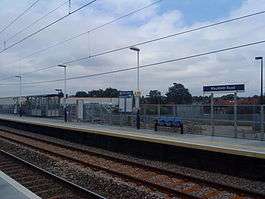
Mauldeth Road railway station in 2009, post-refurbishment | |
| Location | |
| Place | Ladybarn |
| Local authority | Manchester |
| Grid reference | SJ862931 |
| Operations | |
| Station code | MAU |
| Managed by | Northern |
| Number of platforms | 2 |
| DfT category | E |
|
Live arrivals/departures, station information and onward connections from National Rail Enquiries | |
| Annual rail passenger usage* | |
| 2004/05 | 118,566 |
| 2005/06 |
|
| 2006/07 |
|
| 2007/08 |
|
| 2008/09 |
|
| 2009/10 |
|
| 2010/11 |
|
| 2011/12 |
|
| 2012/13 |
|
| 2013/14 |
|
| 2014/15 |
|
| Passenger Transport Executive | |
| PTE | Transport for Greater Manchester |
| History | |
| 1909 | Opened |
| 1974 | Renamed |
| 2007 | Refurbished |
| National Rail – UK railway stations | |
| * Annual estimated passenger usage based on sales of tickets in stated financial year(s) which end or originate at Mauldeth Road from Office of Rail and Road statistics. Methodology may vary year on year. | |
|
| |
Mauldeth Road railway station (known as Mauldeth Road for Withington until 1974) is a suburban railway station serving the Ladybarn area of Manchester, England. It is the last station before Manchester Piccadilly on the Styal Line and was electrified in 1959.
The station is primarily served by a half-hourly Northern service which alternates between Manchester Airport and Crewe. Some peak TransPennine Express services, a number of the Northern services between Southport and Manchester Airport and hourly freight trains from Trafford Park also pass the station.
History
.JPG)
The station opened in 1909 and is positioned south of Longsight (Slade Lane Junction). Originally known as Mauldeth Road for Withington, being renamed Mauldeth Road on 6 May 1974,[1] it now serves the Manchester - Crewe (via Manchester Airport) rail route, used by Northern for stopping services to Manchester Airport. Its coal sidings closed in the 1960s, along with its original platform buildings on the up (southbound) side.
The remaining wooden ticket office on the down side burned down on Bonfire Night in 1986; thereafter the ticket office was a small prefabricated unit at the bottom of the station approach.
It caters mainly for commuter traffic, being electrified at 25kV AC overhead, and is used by EMU traffic. Some evening services are operated by TransPennine Express with DMUs.
Recent developments
As part of a £12 million station modernisation programme on the Manchester Airport Line, re-building work on Mauldeth Road started in Autumn 2006.[2] Network Rail were able to keep the station operational for most of the time by demolishing the existing platforms in small parts and using temporary platforms.
There was a temporary footbridge spanning the platforms while the pedestrians' access ramp to the northbound platform was out of use during renovation; the footbridge offered a vantage point for views over Manchester.[3]
Mauldeth Road station now has new steel platforms, modern waiting shelters, new lighting and access ramps.[4]
The old ticket office, a portakabin used since the late 1980s was removed in 2013. A new ticket office is currently under construction and will be operational by spring 2014.
Services
The Monday to Saturday service pattern is as follows:
- 2 trains per hour to Manchester Airport, one of which continues on to Crewe until 17:53, then terminates at Wilmslow in the evening.
- 2 trains per hour to Manchester Piccadilly.
Sunday services consist of:
- 1 Train per hour to Manchester Airport, with one service every 2 hours continuing to Alderley Edge
- 1 Train an hour to Manchester Piccadilly.
References
- ↑ Slater, J.N., ed. (July 1974). "Notes and News: Stations renamed by LMR". Railway Magazine. London: IPC Transport Press Ltd. 120 (879): 363. ISSN 0033-8923.
- ↑ "Good News for Passengers - Revamped East Didsbury Station Open on Time" (Press release). Network Rail. 2006-09-13. Retrieved 2007-10-25.
- ↑ "Stunning views over Manchester from Mauldeth Rd station temporary footbridge". Retrieved 2007-11-01.
- ↑ "Construction in the UK Transport Industry" (PDF). Unite the Union. Retrieved 2007-10-25.
External links
| Wikimedia Commons has media related to Mauldeth Road railway station. |
- Train times and station information for Mauldeth Road railway station from National Rail
| Preceding station | |
Following station | ||
|---|---|---|---|---|
| Burnage | TransPennine Express South TransPennine |
Manchester Piccadilly | ||
| Burnage | Northern Styal Line |
Manchester Piccadilly | ||
| Bolton | |
|---|---|
| Bury |
|
| Manchester (Manchester station group in italics) | |
| Oldham | |
| Rochdale | |
| Salford | |
| Stockport | |
| Tameside | |
| Trafford | |
| Wigan | |
† stations on the East Lancashire Railway (heritage)
| |
Coordinates: 53°26′02″N 2°12′31.50″W / 53.43389°N 2.2087500°W