Maswa District
| Maswa District | |
|---|---|
| District | |
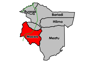 Maswa District's location within Simiyu Region. Paved trunk roads in green. | |
| Coordinates: 03°11′S 033°47′E / 3.183°S 33.783°ECoordinates: 03°11′S 033°47′E / 3.183°S 33.783°E | |
| Country | Tanzania |
| Region | Simiyu Region |
| Population (2012) | |
| • Total | 344,125 |
Maswa District is one of the five districts of the Simiyu Region of Tanzania. It is bordered to the north by Magu District and Itilima District, to the east by the Meatu District, to the south by the Kishapu District, and to the west by the Kwimba District. Its administrative centre is the town of Maswa.
According to the 2002 Tanzanian National Census, the population of Maswa District is 304,402. According to the 2012 Tanzania National Census, the population of Maswa District was 344,125.[1]
Transport
The highway that connects Shinyanga Region and Mara Region (trunk road T36) passes through Maswa town.[2]
The Central Line railway from Tabora to Mwanza passes through the district from south to north and there is one train station within the district's boundaries at the village of Malampaka.[3]
Administrative subdivisions
As of 2012, Maswa District was administratively divided into 26 wards.[1]
Wards
|
|
|
|
|
References
- 1 2 "Census 2012". National Bureau of Statistics. Retrieved 26 January 2015.
- ↑ "Simiyu Roads Network" (PDF). Tanroads. Retrieved 26 January 2016.
- ↑ "Railways Network". Tanzania Railways Limited. Retrieved 7 March 2016.