Mastung District
| Mastung District ضلع مستونگ | |
|---|---|
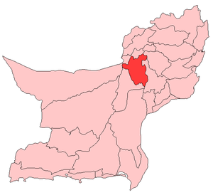 Map of Balochistan with Mastung District highlighted | |
| Country | Pakistan |
| Province | Balochistan |
| Established | 1991 |
| Headquarters | Mastung |
| Area | |
| • Total | 5,896 km2 (2,276 sq mi) |
| Population | |
| • Estimate (2005) | 180,000 |
| Time zone | PST (UTC+5) |
Mastung District (Urdu: ضلع مستونگ) is a district located in the northwest of Balochistan province, Pakistan. Prior to 1991, Mastung was a part of Kalat District. However, for administrative purposes, in 1991 it was separated from Kalat and made a new district.
Administration
The district consists of three tehsils:[1]
Prior to 2006, within these there were 12 union councils: Khadkocha, Ghulam Parenz, Karez Noth, Mastung-1, Mastung-2, Sorgaz, Dasht, Isplinji, Kanak, Shaikh Wasil, Kardigap and Soro. In 2006, one additional union council formed with the name of Alizai, bringing the total union councils to 13.
Demography and languages
In 2005 the population of Mastung district was estimated to be over 180,349. Over 99% of the people in the area are Baloch Muslims. The major languages spoken in Mastung District are: Brahui and Dehwari. Minority Languages are Punjabi, Balochi, Sindhi, Pashto and Urdu.
Brahvi language is spoken by different tribes of the district which include Raisani, Shahwani, Bangulzai, Mahammad Shahi, sarparah, Kurd, Lehri, Lango and Dehwar. Each of these tribes are further divided into classes. Every tribe is headed by Nawab/ Sardar. The classes with in the tribe are headed by Sardars. The other tribes in the area are Syeds, Dehwar, Kurd, Lashari, Rodeni, Mohammad Shahi,Alizai, Satakzai, Shahwani,Mashwani,Sumalani Sarangzai, Lehri, Khurasani, Rind, Tareen,Khilji,Baroozai,Durrani And,Shaikh.
Ex Chief Minister of Balchistan Nawab Aslam Raisani hails from this district. Law and order situation remained a challenge for law enforcement agencies in this district.
See also
- Mastung Valley
- Khwaja Ibrahim Yukpasi
- Khwawa Khail
References
External links
| Wikimedia Commons has media related to Mastung District. |
Coordinates: 29°45′N 67°00′E / 29.750°N 67.000°E