Mashonaland
Mashonaland is a region in northern Zimbabwe. It is the home of the Shona people.
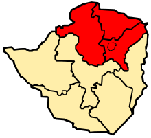
Currently, Mashonaland is divided into Three provinces,
In addition, the Zimbabwean capital of Harare, a province unto itself, lies entirely in Mashonaland.
Provincial history
It was originally one of the regions that the country was divided into following occupation by the Pioneer Column in 1890 and designated the extent of territory under administration of the British South Africa Company as distinct from the remainder of the territory that was directly under the control of the Matabele king, Lobengula, which was named Matabeleland when it was occupied in 1893. The two had separate administrations for part of the BSA Company colonial period.
Revolt broke out against the British South Africa Company in 1896, led by priests of the Mwari religious cult. The British prevailed, executed some leaders, and tried to reform the system.[1]
In 1923, the territory became part of the self-governing colony of Southern Rhodesia and Mashonaland became one of the five provinces. In 1970, an administrative reform led to Mashonaland being divided into a northern and a southern half. Most recently, in 1983, it was divided into the current three sectors and the capital city of Harare was given its own provincial status as well. Since the constitutional amendments that took effect in 1988, each is run by a governor appointed by the president.[2]
Geographical features
The territory is composed of a broad plateau that slopes gradually to the north and north-west. The lowest land is on its northern border, which is formed by the Zambezi River, with Zambia beyond. A small part straddles the plateau at its south-eastern edge and here the land drains into the Save River but the rest of Mashonaland is part of the Zambezi drainage basin. To the south, the Munyati River forms the border with the current and former province of Midlands. The Nyangadzi river forms the border with Manicaland to the east.
Much of the landform is rolling low hills divided by river valleys. About half the land is over 1200 m altitude and the central watershed in the south and centre is at 1500–1650 m. Only a few isolated mountains and the spine of the Umvukwes Range in the west rise higher. The highest point is in the Wedza Mountains in the south east at 1789 m.
References
External links
- Journals of the Mashonaland Mission 1888 to 1892 by G. W. H. Knight-Bruce; account by Anglican bishop.
- Memories of Mashonaland, by G. W. H. Knight-Bruce; 1895 account by Anglican bishop.
- James Anta: African Missionary to Mashonaland