Mascarin Peak
| Mascarin Peak | |
|---|---|
 Mascarin Peak | |
| Highest point | |
| Elevation | 1,230 m (4,040 ft) [1] |
| Prominence | 1,230 m (4,040 ft) [1] |
| Isolation | 1,848 kilometres (1,148 mi) |
| Listing | List of mountains in South Africa |
| Coordinates | 46°54′S 37°46′E / 46.900°S 37.767°ECoordinates: 46°54′S 37°46′E / 46.900°S 37.767°E [1] |
| Geography | |
| Location |
Indian Ocean Prince Edward Islands, South Africa |
| Geology | |
| Age of rock | Holocene |
| Mountain type | Shield Volcano[2] |
| Last eruption | 2004 [2] |
Mascarin Peak (until 2003 called State President Swart Peak), is the highest mountain on Marion Island, with a height of 1,230 metres (4,040 ft).[2] Marion Island is the largest island of the Prince Edward Islands in the sub-Antarctic Indian Ocean. The islands belong to South Africa and are administered by the South African National Antarctic Programme.
Mascarin Peak is South Africa's only active volcano.[2] The last eruption occurred in 2004. Renamed in 2003 after Marion du Fresne's frigate Le Mascarin.[3]
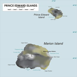
Map of Prince Edward Islands
References
- 1 2 3 "Swart Peak, South Africa" Peakbagger.com. Retrieved 2011-12-18.
- 1 2 3 4 "Marion Island" - Global Volcanism Program. Volcano.si.edu. Retrieved 2015-04-30.
- ↑ Elwyn Jenkins. Falling Into Place: The Story of Modern South African Place Names
This article is issued from Wikipedia - version of the 11/15/2016. The text is available under the Creative Commons Attribution/Share Alike but additional terms may apply for the media files.