Masardis, Maine
| Masardis, Maine | |
|---|---|
| Town | |
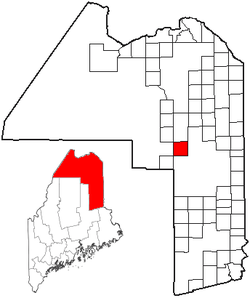 Location of Masardis, Maine | |
| Coordinates: 46°31′7″N 68°22′29″W / 46.51861°N 68.37472°W | |
| Country | United States |
| State | Maine |
| County | Aroostook |
| Area[1] | |
| • Total | 39.92 sq mi (103.39 km2) |
| • Land | 38.73 sq mi (100.31 km2) |
| • Water | 1.19 sq mi (3.08 km2) |
| Elevation | 545 ft (166 m) |
| Population (2010)[2] | |
| • Total | 249 |
| • Estimate (2012[3]) | 246 |
| • Density | 6.4/sq mi (2.5/km2) |
| Time zone | Eastern (EST) (UTC-5) |
| • Summer (DST) | EDT (UTC-4) |
| ZIP code | 04759 |
| Area code(s) | 207 |
| FIPS code | 23-43990 |
| GNIS feature ID | 0582583 |
Masardis is a town in Aroostook County, Maine, United States. The population was 249 at the 2010 census.
Geography
According to the United States Census Bureau, the town has a total area of 39.92 square miles (103.39 km2), of which 38.73 square miles (100.31 km2) is land and 1.19 square miles (3.08 km2) is water.[1]
Climate
This climatic region is typified by large seasonal temperature differences, with warm to hot (and often humid) summers and cold (sometimes severely cold) winters. According to the Köppen Climate Classification system, Masardis has a humid continental climate, abbreviated "Dfb" on climate maps.[4]
Demographics
| Historical population | |||
|---|---|---|---|
| Census | Pop. | %± | |
| 1840 | 140 | — | |
| 1860 | 190 | — | |
| 1870 | 169 | −11.1% | |
| 1880 | 212 | 25.4% | |
| 1890 | 250 | 17.9% | |
| 1900 | 438 | 75.2% | |
| 1910 | 650 | 48.4% | |
| 1920 | 690 | 6.2% | |
| 1930 | 584 | −15.4% | |
| 1940 | 601 | 2.9% | |
| 1950 | 523 | −13.0% | |
| 1960 | 408 | −22.0% | |
| 1970 | 317 | −22.3% | |
| 1980 | 328 | 3.5% | |
| 1990 | 305 | −7.0% | |
| 2000 | 255 | −16.4% | |
| 2010 | 249 | −2.4% | |
| Est. 2014 | 241 | [5] | −3.2% |
2010 census
As of the census[2] of 2010, there were 249 people, 107 households, and 69 families residing in the town. The population density was 6.4 inhabitants per square mile (2.5/km2). There were 166 housing units at an average density of 4.3 per square mile (1.7/km2). The racial makeup of the town was 99.2% White, 0.4% Native American, and 0.4% from two or more races.
There were 107 households of which 24.3% had children under the age of 18 living with them, 53.3% were married couples living together, 2.8% had a female householder with no husband present, 8.4% had a male householder with no wife present, and 35.5% were non-families. 29.9% of all households were made up of individuals and 13% had someone living alone who was 65 years of age or older. The average household size was 2.33 and the average family size was 2.90.
The median age in the town was 46.9 years. 18.5% of residents were under the age of 18; 6.3% were between the ages of 18 and 24; 20.4% were from 25 to 44; 36.8% were from 45 to 64; and 17.7% were 65 years of age or older. The gender makeup of the town was 57.0% male and 43.0% female.
2000 census
As of the census[7] of 2000, there were 255 people, 104 households, and 71 families residing in the town. The population density was 6.6 people per square mile (2.5/km²). There were 158 housing units at an average density of 4.1 per square mile (1.6/km²). The racial makeup of the town was 98.43% White, and 1.57% from two or more races. Hispanic or Latino of any race were 0.39% of the population.
There were 104 households out of which 25.0% had children under the age of 18 living with them, 64.4% were married couples living together, 1.0% had a female householder with no husband present, and 30.8% were non-families. 21.2% of all households were made up of individuals and 9.6% had someone living alone who was 65 years of age or older. The average household size was 2.45 and the average family size was 2.86.
In the town the population was spread out with 23.5% under the age of 18, 4.7% from 18 to 24, 23.9% from 25 to 44, 32.5% from 45 to 64, and 15.3% who were 65 years of age or older. The median age was 44 years. For every 100 females there were 121.7 males. For every 100 females age 18 and over, there were 129.4 males.
The median income for a household in the town was $30,625, and the median income for a family was $32,083. Males had a median income of $32,321 versus $17,000 for females. The per capita income for the town was $14,716. None of the families and 7.0% of the population were living below the poverty line, including no under eighteens and 5.7% of those over 64.
Notable person
- Ormandel Smith (1842-?), Secretary of State and Maine State Treasurer
References
- 1 2 "US Gazetteer files 2010". United States Census Bureau. Retrieved 2012-12-16.
- 1 2 "American FactFinder". United States Census Bureau. Retrieved 2012-12-16.
- ↑ "Population Estimates". United States Census Bureau. Retrieved 2013-07-06.
- ↑ Climate Summary for Masardis, Maine
- ↑ "Annual Estimates of the Resident Population for Incorporated Places: April 1, 2010 to July 1, 2014". Retrieved June 4, 2015.
- ↑ "Census of Population and Housing". Census.gov. Retrieved June 4, 2015.
- ↑ "American FactFinder". United States Census Bureau. Retrieved 2008-01-31.
Coordinates: 46°30′13″N 68°21′40″W / 46.50361°N 68.36111°W